
the weather
Written by: Li Fuyuan
2020-08-19 05:46
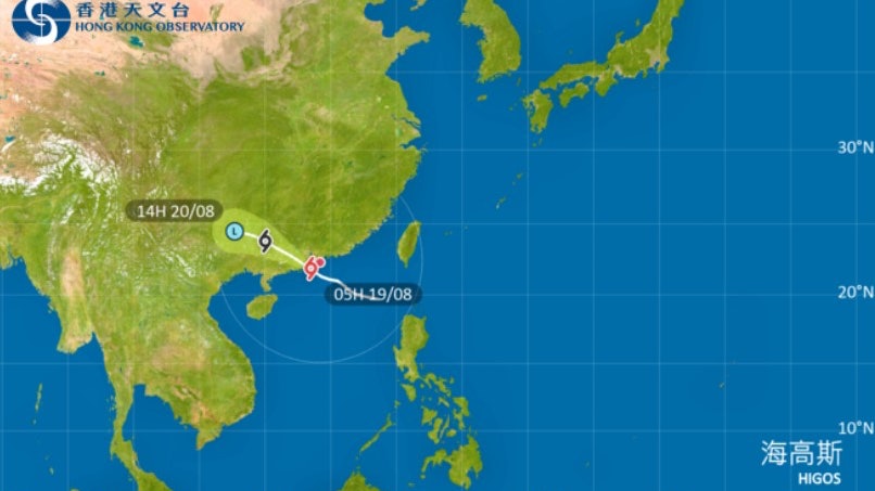
Last update date: 2020-08-19 05:46Typhoon "Hygos" struck Hong Kong. The Observatory announced at 4:45 am on Wednesday (19th) that "Hygos" is expected to start moving away from Hong Kong in the next few hours and then make landfall west of the Pearl River Estuary, but "Hygos" will still be located along the coast of Guangdong Bringing squally and heavy showers, the wind in the western part of Hong Kong is relatively strong. It is expected that the No. 9 gale or storm wind enhancement signal will be maintained for a period of time in the early morning.
According to the Observatory, there will be huge waves and swells on the sea surface of Hong Kong, and it urges the public to stay away from the shore and stop all water activities; affected by the storm surge, some low-lying areas may be flooded or seawater inverted in the morning.
In addition, in the past hour, the highest sustained wind speeds recorded at Cheung Chau, Waglan Island and Cheung Chau Beach were 104, 89 and 77 kilometers per hour respectively, and the highest gusts exceeded 129, 101 and 98 kilometers per hour respectively.
Hygothic Ball | The Observatory’s No. 9 typhoon signal rose to No. 9 in less than 24 hours
Hygos ball. Traffic Updates | MTR Open Section Service Suspends All Buses and Trams Suspend
High Goss Ball | "01" Henghua Village Tai O hits No. 8 typhoon, storm and waves hit the shore
Typhoon Hagos Typhoon Hong Kong Observatory