
Hurricane Laura: Texas and Louisiana on alert 5:28
(CNN) –– More than 70 million people are under threat from severe weather this Tuesday in the Northeast and mid-Atlantic of the United States.
New York, Boston, Providence and Hartford are at risk of severe storms this afternoon and evening, as a cold front cuts through the region. There are even greater chances of severe storms in Philadelphia, Baltimore and Washington.
"The main current threat from severe thunderstorms appears to be damaging storm winds over parts of the Mid-Atlantic," noted the Storm Prediction Center (SPC).
In addition to damaging winds, there will also be the threat of hail.
Severe threat during this Tuesday.
A multi-day threat
Some places, like Pittsburgh and Cleveland, face a threat of severe storms this Tuesday and Wednesday.
"A stagnant front will extend from the upper part of the southeastern Great Lakes to the Mid-Atlantic region early this Wednesday," the SPC detailed.
There is still some uncertainty about the intensity level of some of these storms.
The main threats will continue to include damaging winds and hail, but there is also the possibility of isolated tornadoes.
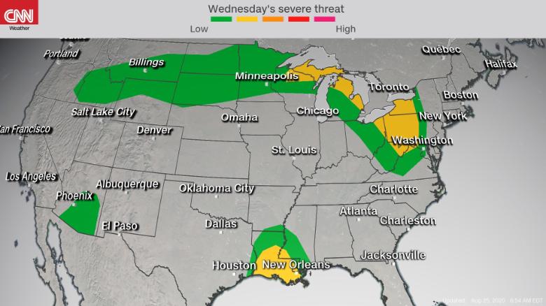
Severe threat during this Wednesday.
For Boston, New York and Providence in Rhode Island, there will only be a small quiet space this Wednesday before the serious threat returns Thursday. At the moment, there is a level 2 ––5 level– threat this Thursday from Nebraska to Massachusetts, but the Northeast areas may need to upgrade to higher probabilities as the event approaches.
After a brief break tomorrow, Thursday severe setup also looks potent. With more shear around there's supercell (rotating storm) potential pic.twitter.com/68Ii8Gz1AP
- Eric Fisher (@ericfisher) August 25, 2020
More severe storms from Hurricane Laura
On the other hand, there is also the possibility of strong storms this Wednesday due to Hurricane Laura.
This will mainly affect the states of Texas, Louisiana and Mississippi on the Gulf Coast. The main threats to the will be damaging winds, tornadoes and waterspouts.
"Hurricanes and tropical storms that make landfall in the Gulf of Mexico are more likely to produce tornadoes compared to storms in the Atlantic," explained Brandon Miller, a CNN meteorologist. “This is because the 'front right' quadrant is where most tornadoes form; this has to do with the wind directions in that part of the storm. With landfalls in the Gulf, this right front quadrant is directly over land, while landfalls from the Atlantic tend to have the right front over the ocean until the storm reaches inland, "he added.
- LEE: Laura is now a hurricane
However, not all coasts of the Gulf of Mexico are equal in terms of this threat.
Note that this is less true for landings in Texas in the Gulf, as the coastline slopes more from south to north like the east coast of the Atlantic, rather than east to west like the north coast. of the Gulf of Mexico of the Panhandle of LA / MS / AL / FL ", clarified Miller.
In other words, a tropical system that makes landfall in Louisiana would likely produce a few more tornadoes than one that makes landfall in, say, Galveston, Texas.
Severe threat during this Wednesday.
HurricaneRainBad weatherWeatherStorms