🔄 Click here to see the most recent entries
25 posts
33 hours ago
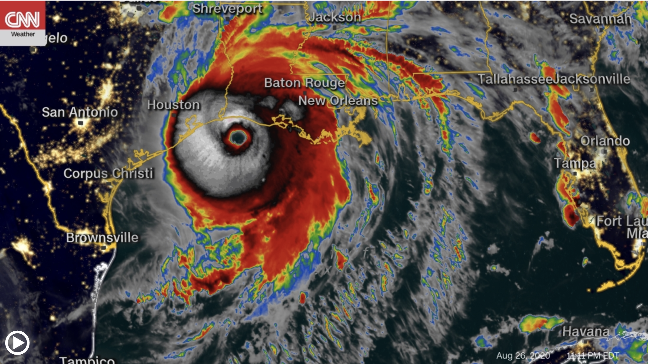
The center of the hurricane moves over Lake Charles
By CNN
Hurricane Laura made landfall about an hour ago near Cameron, Louisiana.
The city is relatively low, with only about 5 to 10 feet (1.5 to 3 meters) of elevation, which means it is "almost completely under water," said CNN meteorologist Tom Sater.
"There will be no possibility of reaching that area until late in the morning," he added.
The center of the storm is now moving over Lake Charles, further north. Conditions have already seriously deteriorated; The winds are howling and storm chasers have reported glass being blown everywhere and ears hurt from the low air pressure.
“At this moment you can still hear the wind. It is howling through the cracks and crevices of the building, ”said CNN correspondent Martin Savidge from Lake Charles, where the CNN team is sheltering indoors.
“When you were outside, you literally felt the whole building shake in the wind. So she's taking a beating. And this is one of the strongest buildings in the area. That is why we chose it.
"All you hear is the roar of a jet engine and literally a world crumbling outside your window," he added.
Storm surge, heavy rains, and high winds mean that damage will be almost impossible to assess until morning; First responders will not be able to travel in these conditions, and drones or planes will not be able to obtain any aerial images. Roads will be submerged and power lines will be down, making transportation or rescue efforts even more difficult.
2 hours ago
Hurricane Laura makes landfall near Cameron, Louisiana
By CNN
Hurricane Laura, still Category 4, has made landfall near Cameron, Louisiana.
Already "catastrophic storm surges, extreme winds and flash floods" are occurring in some parts of the state, according to the National Hurricane Center.
The hurricane is now about 30 miles (45 km) southwest of Lake Charles, Louisiana, and about 40 miles (70 km) east of Port Arthur, Texas.
Maximum winds are still devastating at 150 miles per hour (240 km / h), and the hurricane itself continues to move north at 15 mph (24 km / h).
The storm is expected to move inland through southwestern Louisiana in the next few hours and then head north across the state Thursday afternoon. The center of the storm will then move over Arkansas and the middle of the Mississippi Valley on Friday, and subsequently hit the mid-Atlantic states on Saturday.
3 hours ago
Parts of Louisiana will be submerged under water, warns governor
By CNN
Louisiana Governor John Bel Edwards has warned that parts of the state will be submerged under water by Hurricane Laura.
"The swell will head inland, they predict, there will be parts of Lake Charles underwater that no living human being has seen before," he said in an interview with WWL Radio.
"We are bringing all of our people and assets together to go tomorrow and start a very robust search and rescue effort," Edwards added. "We have brought search and rescue teams from other states, like Tennessee, for example."
"The first thing tomorrow is saving lives, and of course we will transport a lot more people to shelters initially and eventually to hotel and motel rooms."
3 hours ago
The eye wall of the hurricane approaches the Louisiana coast
By CNN
The hurricane's eye wall is approaching the Louisiana coast, the National Hurricane Center warned in its update at 11 p.m. ET.
The center warned that "catastrophic storm surges, extreme winds and flash floods are expected tonight and early Thursday."
Wind gusts in Cameron, Louisiana, are already reaching 67 miles per hour (108 km / h). Meanwhile, gusts at Calcasieu Pass are up to 70 mph (113 km / h).
Most of Cameron's residents have been evacuated, although some remain. About 100,000 residents in the Calcasieu district, where Lake Charles is located, could face potential flooding.
The hurricane's maximum sustained winds remain at 150 mph (240 km / h), as it moves towards the coast at approximately 15 mph (24 km / h).
5 hours ago
Hurricane Laura is about 80 kilometers from making landfall
Dangerous Hurricane Laura is approaching the northwest coast of the Gulf of Mexico, according to the 11 pm bulletin from the National Hurricane Center. The center of the storm is currently located about 75 miles south of Lake Charles, Louisiana, or about 45 miles off the Louisiana coast.
Hurricane Laura is moving north at 15 miles per hour, which means it will make landfall in the next three to four hours.
Hurricane Laura remains a high-level Category 4 hurricane with maximum sustained winds of 150 miles per hour.
Hurricane force winds of 75 miles per hour or more are extending up to 60 miles from the center and are beginning to push towards the coast at this time.
Conditions in southwestern Louisiana and southeastern Texas will rapidly worsen over the next two hours.
5 hours ago
Laura is almost a Category 5 hurricane
Hurricane Laura is just 10 kilometers per hour short of speed to strengthen to Category 5, and it is already stronger than Hurricane Katrina, according to CNN meteorologist Tom Sater.
"It is now in the top 10 strongest hurricanes to make landfall on the continental United States," Sater said. "This will really have an impact, and not only on the coast, but also inland."
Sater warned that the hurricane's winds, reaching 150 miles per hour, could destroy homes, buildings, hospitals, cut power and damage businesses. Power outages could extend from Houston north to Little Rock, Arkansas, in the coming days.
Parts of the shoreline already experience storm surge of 1.1 meters, and that could rise to 4 or 6 feet when the storm makes landfall, almost as high as the top of a second-story building, Sater explained.
7 hours ago
What to expect in the cities that would be affected by Laura? This is the forecast
(Credit: Thomas B. Shea / Getty Images)
Tropical storm force winds are beginning to arrive in southern Louisiana and the extreme southeast of Texas as Hurricane Laura approaches land.
Heavy rains will also begin in coastal cities within the next two hours as conditions begin to rapidly worsen.
Laura is expected to make landfall between 2 a.m. and 4 a.m. Miami time.
Here's what to expect from conditions in some cities:
Beaumont / Port Arthur
Tropical Storm Winds (62 km / h +) = 9 p.m. Wednesday to 9 a.m. Thursday
Maximum Wind Gusts: 170+ km / h
Expected Total Rain = 15-20 centimeters
Lake Charles, Louisiana
Tropical Storm Winds (62 km / h +) = 9 p.m. Wednesday to 10 a.m. Thursday
Maximum Wind Gusts: 170+ km / h
Expected Total Rain = 17-25.4 centimeters
Galveston
Tropical storm winds (62 km / h +) = 8 pm Wednesday to 4 am Thursday
Maximum wind gusts: 72-88 km / h
Total expected rain = 2-7.6 centimeters
Houston
Tropical storm winds (62 km / h +) = 8 pm Wednesday to Thursday 4 am
Maximum wind gusts: 56-72 km / h
Expected total rain = less than 5 centimeters
See the full report here.
8 hours ago
Hurricane Laura continues to gain strength as it approaches the Louisiana coast
Hurricane Laura continues to strengthen into the night this Wednesday, as it approaches the Louisiana coast with winds of up to 150 miles, according to the National Hurricane Center.
Laura is an extremely dangerous Category 4 hurricane and could intensify before making landfall in the next six to eight hours.
If Laura reaches 250 kilometers or more, it will be a Category 5 hurricane. A hurricane of this strength has never hit the Louisiana coast.
8 hours ago
Louisiana Officials Warn Cameron Parish Residents of "Life-threatening" Flooding by Laura
By Dave Alsup
The Cameron Parish Office of Emergency Preparedness warned residents of "life-threatening" flooding before Hurricane Laura.
"Catastrophic and life-threatening flooding is expected not only on the coast, but also in the interior of the Southwest Louisiana I-10 corridor," the agency said on its Facebook page.
The agency warned that "record flooding is expected on the Calcasieu River in the Lake Charles area."
The Grand Lake Bridge in Cameron Parish is closed to travelers.
About the storm: In its latest update, the National Hurricane Center said that "sustained tropical storm-force winds and heavy, steady rains" were "beginning to spread off the coast of Central Louisiana."
8 hours ago
Texas Official Warns Hurricane Laura Could Cause "Significant Damage"
By Eileen McMenamin
Harris County, Texas Judge Lina Hidalgo signed a disaster declaration for the county on Wednesday and warned that Hurricane Laura could cause "significant damage."
"We will avoid a direct hit, but that does not mean that we avoid potential consequences such as power outages or the effects of the wind," he told a news conference in Houston.
"We still anticipate tropical storm winds in our county," Hidalgo said, "that would cause significant damage: the possibility of downed trees, power lines, unsafe road conditions."
The official urged residents to "stay home and get off the roads no later than 8 pm tonight." Hidalgo also noted that now is the time to complete last minute preparations, such as clearing debris and stocking up on supplies like food, water, flashlights, batteries and fuel.
Hidalgo said the Harris County disaster declaration "will help us have additional flexibility to respond and recover."
9 hours ago
Water levels are expected to rise rapidly in the next few hours
The National Hurricane Center warned Wednesday that water levels are expected to rise rapidly.
"Low tide occurred along the northwestern Gulf coast in the last hour, and water levels are expected to rise rapidly overnight and early in the morning due to storm surge and high tide," the entity said in a statement. updated statement.
This means that "insurmountable storm surge, with large and destructive waves" is imminent.
9 hours ago
Video shows the storm surge already hitting Port Bolivar, Texas
By Christina Zdanowicz
Hurricane Laura is still about five hours from making landfall in Texas, but that hasn't stopped it from flooding parts of the coast.
Strong winds are pushing the waters of the Gulf of Mexico towards the coast in Port Bolivar, Texas.
Water levels are about three feet higher than normal, according to the National Oceanic and Atmospheric Administration.
Wilford Raney recorded the following video showing the scene in Port Bolivar this afternoon:
5 hours before landfall at Port Bolivar, Tx - the only way off the island is underwater 4 hours early so I am trapped @WynnWs @cnn @weatherchannel @ abc13houston #HurricaneLaura #BillyBadBird pic.twitter.com/UvIvdcxtrD
- 'BillyBadBird (@BillyBadBirrd) August 26, 2020
10 hours ago
It is not the first time that there has been an extreme warning about a hurricane in this region
By Gene Norman
The National Hurricane Center said Wednesday that Laura's storm surge could be "insurmountable."
The language is reminiscent of the dire warning issued for this part of the Gulf when Hurricane Ike, in 2008, threatened Galveston. At the time, the National Weather Service office in Houston advised those who chose to stay to write their social security numbers on their arms.
The water is already rising rapidly from the storm surge, long before this dangerous hurricane.
You can see exactly how fast it is increasing on this interactive map.
10 hours ago
Images of Hurricane Laura from space
Chris Cassidy, an astronaut aboard the International Space Station, took photos of Hurricane Laura.
The images show the huge hurricane churning in the Gulf of Mexico.
Views of Hurricane Laura taken from @Space_Station today. Stay safe everyone. pic.twitter.com/KwVvRLA15m
- Chris Cassidy (@Astro_SEAL) August 26, 2020
"Everyone stay safe," Cassidy tweeted.
See more of the stunning photographs here.
10 hours ago
Hurricane Laura continues to strengthen before making landfall
By Brandon Miller
Hurricane Laura continues to strengthen this Wednesday afternoon, with sustained winds of up to 230 kilometers per hour in the storm, according to the most recent bulletin from the National Hurricane Center.
Laura is located 249 miles south of Lake Charles, Louisiana, and is moving northwest at 15 miles per hour.
It is expected to make landfall shortly after midnight Central Standard Time, with maximum winds of 150 miles per hour. This will make Laura a top-level Category 4 hurricane, only 10 kilometers per hour apart from a Category 5 storm.
10 hours ago
Tornado Watch for Much of Louisiana and Southeast Texas
The Storm Prediction Center issued a tornado watch for much of Louisiana and southeastern Texas on Wednesday afternoon.
The alert will be in effect until 9 p.m. Central Standard Time, and extends from New Orleans in the east to just west of Beaumont and Port Arthur.
Some context: Hurricane Laura's outer bands bring with them a tornado risk for a wide area, and that danger will likely persist even after the watch expires.
Tornadoes are common when hurricanes and tropical storms make landfall, especially if they occur along the Gulf of Mexico. They are often short-lived and can spin very quickly with little warning.
15 hours ago
Laura intensifies: now it's hurricane 4
Laura is now an extremely dangerous Category 4 hurricane with 225 km / h winds, according to the most recent report from the National Hurricane Center.
Laura could escalate further according to the NHC, and is expected to be Category 4 when it makes landfall after midnight tonight near the Texas-Louisiana border.
13 hours ago
This is the first time in 8 years that Louisiana has activated its full National Guard
By Devon M. Sayers
Louisiana National Guard Sgt. Aaron Dugas prepares a boat for the arrival of Hurricane Laura on August 26, 2020 in Lake Charles, Louisiana (Joe Raedle / Getty Images).
The entire Louisiana National Guard has been activated before Hurricane Laura makes landfall, Governor John Bel Edwards announced at a news conference today. He said the last time the state activated full watch was for Hurricane Issac in 2012.
"We need everyone in Southwest Louisiana to pay close attention to this storm," Governor Edwards said. "People have to heed the warnings they have been given and evacuate," he added. He said storm surge would be "impossible" to survive in some places in the storm's path.
"We believe there will be extensive search and rescue after this storm," Edwards said, part of the reason for activating the full watch.
The governor said that more than 3,000 members of the guard are currently deployed, and that number will increase this afternoon. In addition to personnel, 19 planes, 920,000 liters of water and more than half a million meals have been pre-deployed, Edwards added.
About 2,000 hotel rooms were secured tonight to help house people as a result of the storm and also to help with social distancing, Edwards said.
All commercial traffic along I-10 is diverting north from I-10 to I-20, Louisiana Department of Transportation commissioner Shawn Wilson said at a news conference.
16 hours ago
What is a storm surge and why is it dangerous?
As the powerful Hurricane Laura moves toward the US, there are concerns that strong storm surges are possible.
The latest advisory from the center warned that storm surge up to 15 feet could overwhelm the coasts in Texas and Louisiana
But you may be wondering (and you would not be the only one): "What is a storm surge?"
A storm surge is a gradual rise in water level caused by the winds of a strong storm as it approaches shore.
"As the storm approaches shore," meteorologist Gene Norman told CNN, "it raises the water level by sending those waves inland."
Storm winds push the water towards shore, Norma said. But that water doesn't just come in and then go away.
Over time, with each incoming wave, that water will slowly begin to accumulate, raising the average water level on the shore - similar to the tide - until it ends up swallowing a beach or rises above a jetty.
READ more here.
16 hours ago
This is how Laura looks from space
Images from space show Laura's strength 1:15
16 hours ago
Here's what we know about Hurricane Laura so far
(Joe Raedle / Getty Images)
Hurricane Laura, a Category 3 tropical cyclone, continues to move toward the Gulf coasts of Texas and Louisiana.
This is what we know:
Laura Expected to Go Strong: The National Hurricane Center expects Laura to strengthen into a powerful Category 4 storm before making landfall near the Texas-Louisiana state line Wednesday night or early Thursday, they say meteorologists. You can trace the path of the hurricane here.
Strong storm surges are possible: The latest advisory from the center warned that storm surges up to 15 feet could overwhelm the coasts in Texas and Louisiana
Evacuations are underway: As of this morning, more than 1.5 million people in Texas and Louisiana were under mandatory and voluntary evacuation orders. Local and state officials advise residents to heed these warnings.
17 hours ago
Part of a Louisiana highway is already under water
Archie Chaisson, president of Lafourche Parish of Louisiana, said he took photos of the water that overflowed Louisiana Highway 1 south of the Golden Meadow Floodgates.
"We anticipate that LA 1 will be under water for the next 24 hours," he said.
Chaisson says there is a mandatory evacuation notice posted in Lafourche Parish for the area south of the Golden Meadow Floodgates.
CNN Weather's Haley Brink says the storm surge forecast for this area is between 1.2 to 2.1 meters.
17 hours ago
There will be "unsurpassed storm surges" in parts of Texas and Louisiana
The National Hurricane Center warns that Hurricane Laura could bring an "insurmountable" storm surge to parts of the Gulf of Mexico coast.
"Insurmountable storm surges with large, destructive waves will cause catastrophic damage from Sea Rim State Park, Texas, to Intracoastal City, Louisiana, including Calcasieu and Sabine Lakes," the center said in its 11 am ET update.
And it's not just the people in the gulf who should prepare: the latest advisory said the surge could "penetrate up to 30 miles inland from the immediate coastline."
"Only a few hours are left to protect life and property, and all actions must be rushed to completion," urged the center.
17 hours ago
Louisiana transports residents to hotels instead of shelters due to covid-19 concerns
By Leyla Santiago
The state of Louisiana is actively transporting residents out of its coastal areas as Hurricane Laura looms.
Mike Steele, communications director for the Louisiana State Governor's Office of Homeland Security and Emergency Preparedness, told CNN's Leyla Santiago: “What is being done at the state level, instead of picking them up and taking them to operated shelters? For the state? Being picked up and taken to hotel rooms due to COVID-19 concerns.
17 hours ago
Laura has winds of 185 km / h
Laura's winds have increased to 185 km / h and the hurricane has intensified rapidly overnight and will likely continue to strengthen. Laura is forecast to turn into an extremely dangerous Category 4 storm on Wednesday before making landfall tonight near the Texas-Louisiana border as a major hurricane.
Hurricane Laura