
The dangerous effects of Hurricane Sally 7:14
(CNN) ––
Hurricane Sally could cause “potentially life-threatening” extreme historic flooding throughout Wednesday, ”the National Hurricane Center (NHC) warned.
Hurricanes are commonly seen as threatening strong and powerful winds.
But, in fact, it is water that causes most of the destruction, accounting for almost 90% of deaths.
Hurricane #Sally is likely to produce extreme life-threatening flash flooding through Wed along and just inland of the central Gulf Coast from the western Florida Panhandle to far southeastern Mississippi.
@NWSWPC expects 10-20 "of rain, isolated 30" - historic flooding possible.
pic.twitter.com/RPHVT0LR4F
- National Hurricane Center (@NHC_Atlantic) September 15, 2020
25 to 50 centimeters of rain is expected along the Gulf Coast.
Isolated totals higher than 76 cm possible are also calculated from western Florida to the southeastern coast of Mississippi.
Atlanta, Birmingham, Charlotte and even Greenville, South Carolina, all at least 200 miles from the coast, will see significant amounts of rain that could lead to flooding.
LOOK: Hurricane Sally hits the Gulf Coast and is expected to gain strength before making landfall
Atlanta and Charlotte, North Carolina, would have between 4 and 6 inches of rain through Friday.
Also, Birmingham and Greenville, South Carolina, are forecast to record 6 to 10 inches through Friday.
Sally would cause several months of rain in just a few days
Sally is moving at just 2 miles per hour, according to the 11 a.m. Miami time update from the National Hurricane Center.
It's slower than most humans walk, and it's a big problem.
On average, most humans walk between 4 and 6 kilometers per hour.
When a storm crawls so close to land, like Sally, it leaves large amounts of rain on the shore for days.
Sally moves slowly to Alabama and Mississippi 2:51
“September sees an average of 10 to 12 inches of rain along the Gulf Coast in the Panhandle of Mississippi, Alabama and Florida.
Sally will cause this amount in a couple of hours and will probably produce the equivalent of several months of rain in some areas before the storm leaves the region, ”explained Brandon Miller, a CNN meteorologist.
Additional rains through Friday due to Hurricane Sally.
Models have moved east in the last 24 hours.
That means the heavier rain has also moved further east.
Hence a place like Dauphin Island, Alabama, has a forecast of up to 50 centimeters of rain (and isolated amounts of up to 60 centimeters).
"Ironically, this is the exact spot where Hurricane Danny (1997) set a state record of 93 centimeters," said Pedram Javaheri, a CNN meteorologist.
What is storm surge?
As noted above, 90% of deaths in a tropical system occur due to water.
And half of them are due to storm surge.
Storm surge is the rise in sea level during a major storm.
It is measured as the height of the water above what would be the predicted level of the normal astronomical tide.
It is not always coastal cities that are affected by storm surge - inland places can experience storm surge too.
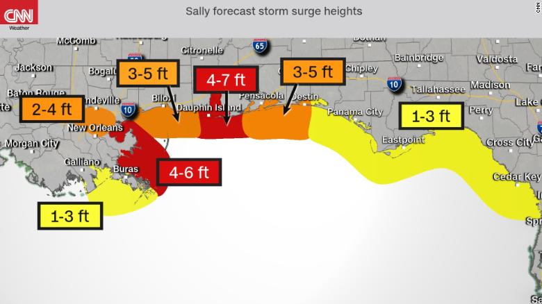
New Orleans, for example, is not on the coast, but will be affected more indirectly through Lake Pontchartrain, which is expected to rise from 60 centimeters to 1.2 meters.
LOOK: Why the storm surge is the greatest threat of a hurricane
As New Orleans and Lake Pontchartrain are currently west of where Sally is anticipated to make landfall, storm surge here will be lower than in other areas to the east, such as Dauphin Island and Gulf Shores, Alabama, which can expect a storm surge from 1.2 to 2.1 meters, or Pensacola and Destin, Florida, with a rise of 91 centimeters to 1.5 meters.
So if New Orleans is on the western side of the storm, where the swell is less, why all the attention on this city?
The answer is that this city is shaped like no other great city in America.
New Orleans is especially at risk of flooding from Hurricane Sally because it is essentially shaped like a bowl.
Because of the drainage system they have installed, the city can act as a strainer allowing water to flow, but when it rains heavily in a short time, the drainage system can become overwhelmed and that strainer acts more like a bowl and floods the city.
Fortunately, since New Orleans is west of where Sally would make landfall, it is only expected to register 2.5 to 5 centimeters of rain, but if the trajectory changes, that estimate could be modified as well.
CNN meteorologist Judson Jones contributed to this article.
Hurricane Sally Floods Swells