Severe weather in Germany: three tornadoes, one fatality - on Monday, "Finja" could be continued
Created: 2022-05-21Updated: 2022-05-21 8:53 PM
By: Patrick Huljina, Martina Lippl, Christoph Gschoßmann, Jennifer Lanzinger, Fabian Müller
Severe weather in Germany: In parts of the country there were extreme thunderstorms with heavy storm and hurricane gusts and tornadoes.
On Monday we continue with low "Finja".
News ticker.
Tornado in NRW: A video shows an alleged tornado sighting.
Three tornadoes have now been confirmed - there are millions of euros in damage in NRW.
Paderborn is particularly affected.
After the weather calmed down at the weekend, a new storm is moving from the south-west towards Germany on Monday.
All information about the severe storms in Germany here in the news ticker.
Update from May 21, 8.45 p.m .:
With low “Finja” the next storm rushes on Monday, especially in the south-west of Germany.
Like a map that the German Weather Service (DWD) shows on Twitter, "Finja" is approaching from France and is likely to hit Baden-Württemberg in particular.
According to the DWD, "Finja" didn't "crack quite as badly as her predecessor" on Friday.
High "Zeus" banishes bad weather at the weekend
Update from May 21, 2:57 p.m .:
After the violent storms in parts of Germany, hail, lightning and thunder are over for the rest of the weekend.
"The new high "Zeus" jumps into the breach, but it doesn't throw lightning around," said a meteorologist from the German Weather Service (DWD) on Saturday in Offenbach.
However, the next low could already cause further thunderstorms at the beginning of the new week on Monday.
Before that happens, people in Germany can get ready for a quiet weekend.
According to the DWD, it will often be clear to cloudy on Sunday, and the sun will be longer in the west, south and center.
"On Monday, the next thunderstorm low threatens new adversity" - again tornadoes?
Only in the Alps and in the Black Forest could something come down.
But it won't be quite as hot as in the past few days.
Temperatures range from 16 to 24 degrees in the northern half, between 22 and 27 degrees in the rest of the country.
also read
Monkeypox in Germany: After Munich, two cases in Berlin - NRW begins contact tracing
Virologist Streeck calls for four autumn measures and commits himself when a fourth vaccination takes effect
"On Monday, the next low storm threatens new adversity," said the meteorologist.
The thunderstorm parameters will hit again, but not as strongly as last Thursday and Friday.
Nevertheless, the DWD again expects local storms in the west and south-west with larger hail, heavy rain and heavy gusts of wind.
Another tornado cannot be completely ruled out.
In the east, on the other hand, it remains cheerful.
The maximum temperatures on Monday are between 21 and 27 degrees.
According to the DWD, the thunderstorms move north-east on Tuesday night and the storm calms down again.
Paderborn Mayor: Massive destruction across the city
Update from May 21, 12:30 p.m .:
According to Mayor Michael Dreier (CDU), the tornado caused massive destruction in several parts of Paderborn with enormous force.
According to the authorities, the tornado caused extensive destruction on Friday in a corridor from west to east that is about 300 meters wide and five kilometers long through the middle of the city.
“The trees in Riemeke Park are literally snapped like matchsticks.
Countless roofs have been completely designed with the pans.
A lot of windows were smashed by the wind," Dreier said at a press conference on Saturday.
In the heart of the city, where the new central bus station is being built, traffic lights have been broken like matches.
Trees fell on a bus, fortunately no one was seriously injured.
The tornado destroyed countless roofs and panes around the headwaters of the Pader and made apartments uninhabitable.
"It was, and still is, an unimaginable image," he said.
The roof of the Liborianum was badly damaged.
The roof tiles would have “eaten” into the plaster of neighboring houses.
In a corridor about 300 meters wide, there was a high degree of destruction.
In an industrial area, companies were completely destroyed.
According to him, the tornado caused crash barriers to fly through the area like shredded paper.
Police director criticizes onlookers in Paderborn
Update from May 21, 12:29 p.m .:
After the passage of a tornado, the authorities in Paderborn praised the great willingness of the population to help.
But there was also criticism of citizens who hindered the clean-up and rescue work.
"People's willingness to help was immense," reported Paderborn's chief police officer, Ulrich Ettler, at a press conference on Saturday.
"Unfortunately, there were also some citizens who were so bold as to disregard barrier tapes and hinder the work of the rescue services."
It happened again and again that individuals wanted to break through the barriers.
The clean-up work would still take some time: "I can only appeal again: stick to the barriers, keep escape routes clear.
Onlookers have no place in the city center,” said Ettler.
According to Ettler, the main police building in Paderborn was also badly damaged.
“The service building is in the center of the destructive swath.
This tornado hit us right away.
There are a lot of broken trees there.
A roof of the police headquarters has been covered.” A police officer was slightly injured during an operation when he and colleagues tried to rescue two people from a jammed vehicle.
A tree crashed through the windshield of a fire truck, leaving the two occupants unharmed.
Paderborn: 13 seriously injured, including one seriously injured
Update from May 21, 11:32 a.m .:
According to the city, 13 people were seriously injured in the tornado in Paderborn on Friday – including one seriously injured.
A total of 43 were injured, Mayor Michael Dreier (CDU) said at a press conference on Saturday.
More than 400 emergency services were on the road.
According to Interior Minister Herbert Reul (CDU), more than 7,500 emergency services were on site during the severe storm in North Rhine-Westphalia.
"More than 7,500 emergency services from the fire brigade and aid organizations have once again given their all across the country in the past 48 hours to prevent things from getting worse," Reul told the German Press Agency on Saturday.
He is extremely grateful to the forces for their courageous commitment.
"I am saddened by the extent of the destruction left by the tornadoes in Lippstadt and Paderborn," he added.
Severe weather in Germany: Three confirmed tornadoes - 43 people injured in Paderborn
Update from May 21, 10:50 a.m .:
Severe storms with at least three tornadoes left over 40 injured and millions in damage in the east of North Rhine-Westphalia.
The city of Paderborn, where 43 people were injured, according to the police, is hardest hit.
Some of them heavy, said a police spokesman on Saturday morning of the German Press Agency.
A seriously injured person was flown to a hospital in Bielefeld.
The German Weather Service (DWD) confirmed three suspected tornado cases to the German Press Agency on Saturday.
Accordingly, tornadoes occurred in Paderborn, Lippstadt and in Lütmarsen, a district of the city of Höxter.
There were also other suspected tornado reports for Ratingen near Düsseldorf and from the Sauerland, which would have to be checked further.
The three confirmed tornadoes formed in connection with particularly strong thunderstorms, explained a DWD spokesman.
They appeared on a small scale.
He has not yet provided any information on the wind speeds.
There was also precipitation of sometimes 30 to 40 liters per square meter in a short time during the storm on Friday afternoon and evening.
The thunderstorms passed relatively quickly.
According to the DWD, hail also fell in some places during the storm.
According to the police, extensive clean-up work is pending in the particularly affected city of Paderborn.
Loose roof tiles, fallen scaffolding and fallen branches that crashed into windows - this is how a police spokesman described the damage in Paderborn.
There was major damage to the building in a commercial area in the city.
A spokesman for the Paderborn fire brigade initially did not want to comment on the current status on Saturday morning and referred to a press conference planned at short notice by the authorities in the morning.
Two trucks overturned at a Paderborn car dealer.
© Lino Mirgeler/dpa
Storm over Germany: First fatality
Update from May 20, 9:50 p.m .:
Numerous injuries caused the storm over NRW, now there is a first fatality.
As reported by the police, a 38-year-old man is said to have died in a house in Wittgert in the Westerwald district in Rhineland-Palatinate.
Accordingly, the man was with friends in the house.
This had a flooded basement.
The man suffered an electric shock, which caused him to fall and probably hit his head.
Storms over Germany: DWD expects thunderstorms during the night
Update from May 20, 9:15 p.m .:
In Rhineland-Palatinate and Saarland, despite massive thunderstorms, there was no major damage until the evening.
Police and rescue workers reported isolated fallen trees, hail damage to cars and flooding of basements.
There were initially no reports of injuries.
The German Weather Service expects some severe thunderstorms in the south on Saturday night.
Otherwise the thunderstorms should move towards Poland and the weather should calm down from the west.
On Saturday there could still be isolated short thunderstorms with stormy gusts in the north-east, which will subside in the afternoon.
Severe weather over Germany: numerous injuries - several tornado reports
In Lippstadt, the storm sweeps away a church spire.
© Marc Gruber/Imago
Update from May 20, 8:15 p.m .:
In the severe storm on Friday, 30 to 40 people were injured in the Paderborn area, at least 10 of them seriously.
"During a thunderstorm on Friday afternoon, a tornado cut a path of destruction from west to east through the middle of Paderborn in the direction of the eastern parts of the city," the police said in the early evening.
Officials reported millions in damage.
In an industrial area, the roofs of halls had been torn down.
Sheet metal, insulation and other materials were flown for kilometers.
The fire brigade also reported a suspected tornado in Lippstadt, about 35 kilometers away, which had caused serious damage.
A fire department spokesman said there were destroyed roofs and fallen trees throughout the city.
Windows shattered and cars were destroyed by falling branches.
The Altenbeken municipality near Paderborn reported that some of the trees had already snapped at the trunk - as if hit by a giant's hand.
The German weather service DWD had temporarily issued the highest storm warning level 4 for the region - "extreme thunderstorms" with hailstorms, heavy rain or extreme hurricane gusts.
A DWD spokesman said that several reports of tornadoes had been received - not only from Lippstadt, but also from Lüdenscheid and Meschede.
However, these reports still need to be verified.
Storm over NRW: around 40, some seriously injured, path of devastation
Update from May 20, 7.40 p.m .:
A suspected tornado caused massive damage in Lippstadt in NRW on Friday afternoon around 5 p.m.
The entire city area was affected, said a fire department spokesman.
Numerous roofs were covered and trees fell on cars.
However, according to previous reports, there were neither deaths nor injuries.
At times, around 120 bathers were trapped in the Cabrioli leisure pool in Lippstadt because fallen trees blocked the entrance.
The trapped people were later freed, the fire brigade reported.
In the district of Hellinghausen, the top of a church fell down due to the storm.
Around 200 to 300 firefighters are deployed.
The Lippstadt fire brigade is supported by forces from several neighboring towns.
The task force in the Soester rescue center is pulling together forces from the region in Lippstadt, it said in a statement.
The first thing to do is to get an overview of the damage.
As the media consistently report, citing the Paderborn police, there are said to be 30 to 40 injured, 10 of them seriously.
A roof batten is stuck in the windshield of a parked car.
A storm also caused major damage in Paderborn.
© Lino Mirgeler/dpa
Storm over NRW - several injured in Paderborn
Update from May 20, 6:45 p.m .:
The storm also caused major damage in Paderborn on Friday.
According to the first findings, there were several injuries, said a fire department spokesman in the early evening.
He reported covered roofs and uprooted trees.
A dpa reporter reported that trees had fallen on cars.
"It's chaos here right now," said a police spokeswoman.
A suspected tornado also caused massive damage in Lippstadt, about 35 kilometers away, in the afternoon.
Highest storm warning level: video shows suspected tornado in NRW - severe damage in the city area
Update from May 20, 5:55 p.m .:
The first alleged tornado sighting is doing the rounds on Twitter.
A user documented a supposedly violent hurricane that passed a few houses away.
The authenticity of the video cannot be verified at this time.
According to the user, he is located in Lippstadt, North Rhine-Westphalia.
A fire brigade spokesman said there was serious damage throughout the city.
Numerous roofs were covered and trees fell on cars.
He was not aware of any deaths, the spokesman said.
According to the weather map of the DWD, the most severe storms are currently moving across large parts of central Germany.
The highest severe weather warning level continues to apply in several regions.
The meteorologists speak of heavy thunderstorms, extremely heavy rain, hail and hurricane gusts.
Severe weather in Germany: "Short but heavy rain band over the city"
Update from May 20, 4:48 p.m .:
In Düsseldorf, a “short but productive band of rain fell over the city”.
This was reported by the responsible fire brigade.
One had been called to a large number of "damage sites" and is now trying to provide help everywhere.
The DWD has updated its warning map.
In the meantime, the highest storm warning level 4 applies in the south of North Rhine-Westphalia and in the north-east of Rhineland-Palatinate. The districts of Euskirchen, Ahrweiler, Neuwied, Mayen-Koblenz, Vulkaneifel and the Eifelkreis Bitburg-Prüm are affected.
"Close all windows and doors!
Secure items outdoors!
In particular, keep your distance from trees, scaffolding and high-voltage lines!
If possible, avoid spending time outdoors!” warns the DWD for this area.
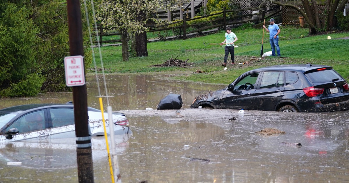
Severe weather in Germany: slight flooding in NRW possible
Update from May 20, 4 p.m.:
According to the assessment of the responsible State Office for Nature, Environment and Consumer Protection (LANUV), there could be slight flooding in North Rhine-Westphalia on Friday.
"According to current calculations, it is likely that flood information values will be exceeded in the Erft catchment area, but other catchment areas may also be affected, including in the northwest half of NRW," the office said on Twitter.
According to LANUV, an exact prediction of the affected areas is currently not possible.
Since the heavy rain is expected to be locally limited, the water levels could rise quickly and significantly, especially in smaller streams.
Severe weather in Germany: First official warning for NRW
Update from May 20, 2:52 p.m .:
The DWD issued a first official severe weather warning for parts of North Rhine-Westphalia in the afternoon.
Among others for Düsseldorf and Cologne.
There could be heavy rain and gusty winds.
In North Rhine-Westphalia, numerous events were canceled as a precaution due to the weather.
In Cologne, among other things, the zoo and the forest botanical garden were closed.
The city warned that trees could fall or branches break off.
In Dortmund, the zoo was closed all Friday.
Two paragliders died in a crash in Saxony-Anhalt on Thursday.
They were probably caught in a gust of wind.
Storm in Germany: NRW Minister of the Interior warns – "Please stay at home"
Update from May 20, 12:05 p.m .:
North Rhine-Westphalia’s Interior Minister Herbert Reul (CDU) has addressed the storm warnings to the population.
"Please stay at home.
Avoid spending time outdoors.
In particular, keep your distance from buildings, trees, scaffolding and high-voltage lines!
Don't go into the basement or lower floors," he told the German Press Agency.
Reul called on people to be particularly careful.
The population should take the “warnings of the German Weather Service very seriously”.
The NRW interior minister called for information on warning apps such as "Nina" and "DWD Warnwetter".
In addition, citizens should pay attention to siren alarms and radio and loudspeaker announcements.
Severe weather in Germany: DWD warns of "locally very violent thunderstorms" from noon - tornadoes possible
Update from May 20, 11:20 a.m .:
A storm front is moving across Germany today.
From the midday hours, "locally very violent thunderstorms" will spread from the west to NRW and Rhineland-Palatinate, writes the DWD on its website and Twitter.
The risk of storms is increased.
According to the German Weather Service, “locally extremely heavy heavy rain of around 40 liters per square meter in a short time, large hail of up to 5 centimeters and heavy gusts of wind to hurricanes with speeds between 100 and 130 kilometers per hour” are expected.
Isolated tornadoes are "not excluded".
In some regions, school is canceled due to the warnings.
In the administrative district of Cologne, for example, classes end at 11:30 a.m.
This ensures that the students come home safely, said a spokesman for the district government.
In the afternoon the thunderstorms will move further east.
In the evening there can also be some strong thunderstorms in the south of the country with the potential for severe weather, mainly due to heavy rain and hail.
Update from May 20, 7:31 a.m
.: The first thunderstorms are already on the way on Friday morning.
According to the DWD, there are strong thunderstorms from the Rhine-Main area to the Vogelsberg district and also on the Hunsrück.
The weather experts are also providing the first severe weather timetable for Germany: “Thunderstorms with high potential for severe weather from the west from the midday hours, moving eastwards across the middle of the country in the afternoon,” writes the DWD on Twitter.
Severe weather in Germany: Deutsche Bahn prepares travelers for train cancellations and delays
Update from May 20, 7.15 a.m
.: Deutsche Bahn prepares train travelers in advance for delays and train cancellations due to the “Emmelinde” storm.
Those who book a ticket can flexibly postpone their trip within the next seven days.
Seat reservations can be exchanged free of charge.
DWD warns of severe storms on Friday
Update from May 20, 6:08 a.m
.: The storm situation increases significantly on Friday.
From France, a thunderstorm will move from the west across northern Germany over the course of the day.
The German Weather Service (DWD) warns of a severe thunderstorm situation, especially in a strip from
NRW
and northern
Rhineland-Palatinate
to
Brandenburg
and
Saxony
.
The thunderstorms are accompanied by heavy gusts of wind or hurricanes between 90 and 130 km/h (Bft 10-12) as well as heavy rain of around 40 l/m² in one hour and hail with a grain size of around 5 cm.
Extremely heavy rain of around 60 l/m² is also likely in a few hours.
Individual
tornadoes
are not excluded either.
In the flood area of Ahrweiler (Rhineland-Palatinate), most schools remained closed due to the storm warning.
The district also recommends looking after daycare children at home on Fridays.
Heavy
storm or hurricane gusts
between 90 and 130 km/h (Bft 10-12)
Heavy
heavy rain up to 40 liters
per square meter in one hour
Hailstones
r with a size around
5 centimeters
Tornadoes
are not excluded
Lightning and thunder!
The storm situation goes into the next round.
The DWD warns of a severe thunderstorm on Friday.
© Armin Weigel/dpa
Severe weather in Germany: Thunderstorm front moves over Germany
Update from May 19, 10:42 p.m .:
The worst thunderstorms for today have moved across Germany, only for the east of Bavaria, north and east of Landshut is the German Weather Service currently still issuing a storm warning level 3.
Severe weather warning level 2 applies to large parts of Franconia. Another day that is at least as stormy is expected on Friday, we will keep you up to date here.
Kreiszeitung.de reports on the storms in the north.
Update from May 19, 9:08 p.m .:
No people were injured and major damage was caused by the announced storms in Hesse by Thursday evening.
Police headquarters in Fulda, Darmstadt and Offenbach reported some fallen trees and covered bricks.
In Frankfurt, Kassel, Giessen and Wiesbaden, the respective praesidia did not report any special events in connection with the weather situation.
Weather in Germany: Grid front moves east
Update from May 19, 8:52 p.m .:
The first thunderstorm cells of severe weather warning level 3 are now moving over Baden-Württemberg.
The region east of Stuttgart and Heilbronn is particularly affected.
North of Berlin and on the Baltic Sea, warning level two now applies, where the DWD also warns of gusts of wind.
Update vom 19. Mai, 20.10 Uhr: Die Gewitterfront ist laut DWD mittlerweile weiter in Richtung Osten gezogen. Unwetterwarnungen der dritten Stufe bestehen nun vor allem für den nordbayerischen Raum von Aschaffenburg über Würzburg bis Coburg. Der DWD warnt vor schweren Gewittern mit Orkanböen, heftigem Starkregen und Hagel.
Alarmstufe Rot: Extreme Gewitter und Superzellen drohen - Schwerverletzter nach Blitzeinschlag auf Frachter
Update vom 19. Mai, 19.01 Uhr: In Frankfurt steigt gleich die große Party des Europa-League-Siegers. Der Deutsche Wetterdienst warnt nun aber die Eintracht-Fans: „Es ziehen Gewitter mit Starkregen, Sturmböen und Hagel auf“, schreibt der DWD auf Twitter. Im Cabrio-Autokorso, wie eigentlich angekündigt, dürften die Spieler wohl eher weniger Spaß haben.
Update from May 19, 5:57 p.m .:
A person was seriously injured in a lightning strike on a cargo ship in Duisburg.
A fire department spokesman said it was probably an employee on the ship.
He was on the freighter in NRW during the severe storm on Thursday afternoon.
The lightning struck the deck and seriously injured the man, the spokesman said.
The Westdeutsche Allgemeine Zeitung
had previously
reported on the lightning strike.
Severe thunderstorms are brewing in the west.
The DWD warns of severe weather (archive image/montage).
© Matthias Balk/dpa/DWD graphics
Update vom 19. Mai, 17.40 Uhr: Der Deutsche Wetterdienst hat seine Unwetterwarnungen aktualisiert. Derzeit verläuft in einem breiten Band von Norden ab Bremen über Hannover eine Gewitterfront bis in den Süden Hessens und in die Region rund um die Hauptstadt Mainz des Bundeslandes Rheinland-Pfalz. Der DWD hat eine Unwetterwarnung der Stufe 3 ausgesprochen. Bald dürfte die Gewitterfront auch die Großstadt Frankfurt am Main erreichen.
Explosive Wetterlage in Deutschland: Gewitter und Superzellen legen Teile des Zugverkehrs lahm
Update vom 19. Mai, 16.50 Uhr: Wegen des Unwetters in den Niederlanden ist kein Zugverkehr von und nach Deutschland aus den Niederlanden möglich. Das meldet die Deutsche Bahn via Twitter.
Update vom 19. Mai, 16.45 Uhr: Der DWD meldet Gewitter-Windböen von 105 km/h - das entspricht einer Windstärke von Bft. 11. Gemessen wurden die Werte in der letzten Stunde an den Stationen Münster/Osnabrück.
Update vom 19. Mai, 16.20 Uhr: Achtung Unwetter! In Niedersachsen, Nordrhein-Westfalen, Rheinland-Pfalz und Baden-Württemberg warnt der DWD vor schweren Gewittern mit großen Hagelkörnern, Starkregen und Orkanböen. Eine Gewitter-Linie zieht aktuell von West nach Ost über Deutschland.
Explosive Wetterlage: Extreme Gewitter und Superzellen drohen - Alarmstufe Rot in ersten Regionen
Update vom 19. Mai, 14.25 Uhr: Unwetterwarnung – Alarmstufe Rot! Der Deutsche Wetterdienst (DWD) warnt jetzt vor schwerem Gewitter mit Orkanböen, heftigem Starkregen und Hagel. Die Gewitter erreichen den Westen und Nordwesten Deutschlands. Rund um den Raum Aachen (NRW) ist die DWD-Unwetterkarte farblich rot markiert. Hier gibt es gefährliche Gewitter mit orkanartigen Böen (bis 110 km/h) sowie heftiger Starkregen bis 40 Liter pro Quadratmeter in kurzer Zeit und dicken Hagelkörnern (bis zwei Zentimeter). Die Warnung gilt aktuell bis 15.45 Uhr.
Update vom 19. Mai, 13.30 Uhr: In den kommenden Stunden warnt der Deutsche Wetterdienst (DWD) vor kräftigen Gewittern und starkem Regen, die vom Westen aufziehen. Die Feuerwehr Köln warnt via Twitter „Was bei Gewitter zu beachten ist?“ Erster Verhaltenstipp der Feuerwehr: „Runter vom Fahrrad, raus dem Wasser und Schutz in festen Gebäuden suchen!“ Auch Bäume jeder Art sind zu meiden, wie Masten, Metallzäune. Wer sich im Freien aufhält, sollte bei Gewitter den Regenschirm weglegen, nicht stehen bleiben und am besten in die Hocke gehen.
Unwetter in Deutschland – Erste Gewitter ziehen vom Westen auf
Update vom 19. Mai, 12.12 Uhr: Vom Südwesten ziehen die ersten Gewitter auf. Alarmstufe „Orange“ – eine amtliche Warnung vor starkem Gewitter hat der Deutsche Wetterdienst (DWD) für den Raum Aachen (NRW) bis runter nach Saarbrücken herausgegeben. Hier kann es jetzt schon zu Starkregen mit Niederschlagsmengen um 15 Liter pro Quadratmeter und Windböen mit Geschwindigkeiten bis 60 km/h kommen.
Unwetter-Fahrplan für Deutschland: Ab 14 Uhr gilt Alarmstufe „Rot“ im Westen
Schwere Gewitter erwartet der DWD ab dem Mittwochnachmittag. Ab 14 Uhr bis 22 Uhr gilt aktuell Alarmstufe „Rot“ im Westen Deutschlands. Es besteht die Gefahr von heftigem Starkregen zwischen 25 und 40 Liter pro Quadratmeter in kurzer Zeit. Zudem können Sturmböen oder schwere Sturmböen zwischen 80 und 100 km/h, lokal auch Orkanböen um 120 km/h auftreten. Örtlich ist auch größerer Hagel über 2 Zentimeter wahrscheinlich. In einem breiten Streifen trifft es demnach zuerst Nordrhein-Westfalen, Saarland und Rheinland-Pfalz.
Explosive Wetterlage: Extreme Gewitter und Superzellen drohen
Erstmeldung vom 19. Mai 2022
München/Offenbach – Über den Niederlanden hat es schon in der Nacht gekracht. Erste schwere Gewitter ziehen im Tagesverlauf im Westen und Nordwesten auf. Der Deutsche Wetterdienst (DWD) warnt vor kräftigen Gewittern mit Starkregen (bis zu 40 Liter pro Quadratmeter in kurzer Zeit), Hagel (bis drei Zentimeter) und teils schweren Sturmböen oder orkanartigen Böen (um 120 km/h).
Unwetter-Alarm in Deutschland: Gewitter mit großem Hagel und „Tornado-Potential“
In den frühen Nachmittagsstunden (ab 14 Uhr) rechnen die DWD-Wetterexperten mit den ersten schweren Gewittern im Westen. Eine Vorabinformation „auf eine Wetterlage mit hohem Unwetterpotential“ ist raus. Der DWD weist ausdrücklich darauf hin, dass Gewitter, mit den genannten Begleiterscheinung typischerweise sehr lokal auftreten und mit voller Intensität meist nur wenige Orte treffen würden.
Nach einer kurzen Wetterberuhigung drohen am Freitag aber erneut schwere Unwetter. Am Abend ist auch in der Mitte Deutschlands mit teils schweren Gewittern zu rechnen. Tornados schließt auch der DWD am Freitag nicht aus.
Extreme Unwetterlage droht am Freitag
„Vor allem am Freitag droht eine extreme Unwetterlage. Die Wettermodelle tischen uns da gerade Karten auf, die selbst wir als erfahrene Meteorologen wirklich selten zu Gesicht bekommen“, gesteht Meteorologe Lars Dahlstrom in einem Video vom wetterkanal.kachelmannwetter.com. Ein Gewittertief von Belgien nähert sich und zieht mit seinem Zentrum von West nach Ost über Deutschland hinweg. Dabei könnten sich Gewittercluster mit heftigem Starkregen, Orkanböen und Großhagel entwickeln. Auch die Tornado-Gefahr sei erhöht.
In der feuchtwarmen bis heißen Luftmasse steigt das Gewitterpotential deutliche an, betont Meteorologe Dominik Jung von wetter.net. „Am Freitag könnten sich genau über und um Nordrhein-Westfalen Superzellen bilden“, so der Wetterexperte. Superzellen sind ein Zusammenschluss von mehreren Gewitterzellen zu einer großen. Dabei könnte es dann zu Orkanböen, heftigen Sturzfluten und großem Hagel kommen.
„Das könnte sich ähnlich entwickeln wie das verheerende Pfingstunwetter im Jahr 2014 in Nordrhein-Westfalen“, fürchtet Meteorologe Jung. Einige Details würden darauf hindeuteten, doch abschließen lasse sich das noch nicht sagen. Auch rund um das Ahrtal in Rheinland-Pfalz gibt es seiner Ansicht nach ein erhöhtes Potenzial für Superzellen. Sturzregen könnte zu Überschwemmungen führen, warnt Jung. Allerdings sei die Wetterlage nicht mit der aus dem Juli 2021, die zur Flutkatastrophe führte, vergleichbar. Damals habe es sich um ein riesiges Starkregenband gehandelt, das schon vier Tage zuvor abschätzbar gewesen wäre. „Bei dieser Lage handelt es sich um eine klassische Gewitterlage, die lokale Unwetter bringen kann, also kein flächiges Ereignis sein wird, wie die Flutkatastrophe im Juni vergangenen Jahres“, betont Wetterexperte Jung.
Weather in Germany: DWD warns of severe storms on Thursday and Friday
Severe storms in Germany: Thunderstorms on Thursday and Friday
Severe weather conditions on Thursday
: west and north approaching thunderstorms.
Severe weather conditions on Friday
: Larger thunderstorm clusters can form in western Germany, Rhineland-Palatinate and North Rhine-Westphalia.
Extreme storms threaten here, especially in terms of wind speeds.
We will keep you up to date on the storm situation on Thursday and Friday in our news ticker.
(ml)