
MORE INFORMATION
In the guide 'Spain a Pie' (GeoPlaneta)
From the Long Distance trails - with their characteristic red and white stripes marked on trees and rocks along the way - to the oldest pilgrimage routes.
And from the circular paths for all levels, ideal for family activities, to the most demanding challenges that climb mythical mountains.
These are 10 classic routes through Spain designed for lovers of calmly crossings, enjoying the natural environment that unfolds with each step they take.
A hiker looks out over one of the coves in the Cabo de Gata-Níjar natural park, in Almería.
Luis Dafos alamy
1. Along the coasts of Cabo de Gata (Almería)
Finding a stretch of virgin coastline in the Mediterranean peninsula is almost a utopia. But the unusual sometimes happens. At the southeastern end of the Peninsula, the Cabo de Gata-Níjar natural park in Almeria has been a protected area since 1987 that encompasses a set of natural ecosystems with great landscape value. A wild, arid territory of volcanic origin that occupies 476 square kilometers and that constitutes an oasis, almost a mirage, safe from the pickax and the urbanization fever that has so degraded other areas of the Andalusian coast. A stony coastline of 50 kilometers that can be covered following the rugged pattern of its coast: a succession of beaches and coves in the middle of a desert, which means that high temperatures (mild in winter) are guaranteed, but also spectacular landscapes.
Starting from
Retamar
, a district of the municipality of Almería that serves as the entrance to Cabo de Gata, to
Agua Amarga
, at the other end of the natural park and dependent on the municipality of Níjar, there are about 60 kilometers that run parallel to the Mediterranean and that they can travel in three days. First you travel along the western coast, on a flat promontory, surrounded by beaches; and then you access the rugged south and east coasts, full of quiet sandy areas and hidden coves. Being an area with a widely scattered population, the location of the places with accommodation makes it impossible to divide the trail into three equal days. Therefore, it is convenient to make a third day shorter and spend the first night in the pleasant town of
San José
and the next one in
Las Negras,
a pebble beach next to an imposing volcanic rock cape.
Along the way, the combination of a dry and desert climate with the cliffs of the Sierra del Cabo de Gata, which plunge into the waters of the Mediterranean, result in an environment that always catches our senses by surprise.
Between the cliffs and the headlands there are some of the best and emptiest beaches in Spain.
At least for now.
A woman walks a track in the Teide National Park.
Jan Wlodarczyk Alamy
2. The ascent to the great volcano: Teide (Tenerife)
The highest mountain in Spain (3,718 meters of altitude) offers a pleasant and rigorous challenge to hikers. And better if this is faced outside the high summer season, when visitors (four million a year) to Teide,
the
largest and oldest of the national parks of the Canary Islands
, decrease considerably. Then the trail improves, especially in early spring when the lower slopes start to bloom and hopefully the summit still has snow.
The true
tour de force
is the ascent to the peak of the volcano, especially if you opt for the very hard six-hour walk, the so-called
Montaña Blanca trail
, with a length of
8.2 kilometers
and a cumulative difference of
1,194 meters
. Its initial section runs along the Montaña Blanca track, on the slopes of Teide, where yellowish-white pumice deposits proliferate as a result of the last eruption, 2,000 years ago. Upon reaching the slope of Teide, the old access road to the peak begins, which goes up the
Lomo Tieso
path
to the
Altavista Refuge
and that presents a strong unevenness, which sometimes exceeds 60%. The slope, coupled with the high altitude, makes it remarkably tiring. The path continues to climb, with less slope, over black streams of young lava, not yet colonized by the vegetation. The trail ends at La Rambleta, next to the
La Fortaleza viewpoint.
During the demanding ascent, the broom (a type of bush) will accompany us much of the time, until approximately 3,400 meters of altitude
the vegetation seems to disappear completely.
If the weather or the strength of the lungs make the walk impossible,
the cable car is a good alternative
.
The base station of the Teide funicular is perfectly accessible by road and is located at an
altitude of 2,356 meters
.
Its modern facilities have two cabins with a maximum capacity for 44 passengers, which allow you to climb Mount Teide in a journey of about eight minutes.
There are other pleasant excursions in the 190 square kilometers of the park, in whose vast domain there are 1,000 Guanche archaeological sites protected by Unesco and 14 unique plant species in the world.
If we want
a less crowded but almost equally challenging climb,
there is another volcano in the surroundings that also exceeds 3,000 meters in height and that can be crowned in another highly recommended hiking route: the
Pico Viejo
or
Montaña Chahorra.
There are 13 kilometers of ascent for which it will take about six hours for the unevenness to be covered.
A group crosses the El Chorro gorge, in the Caminito del Rey (Malaga).
Rebecca Carter / EyeEm getty images
3. Through the walkways and hanging bridges of the Caminito del Rey (Malaga)
Who dares to walk a path that until not long ago was nicknamed "the road of death"?
The Caminito del Rey,
north of Malaga, reopened in 2015 (after more than 10 years closed to the public) with the construction of a new totally safe footbridge over the Gaitanes gorge, about a hundred meters above the
Guadalhorce river. .
But it still produces grief.
Fourteen thousand meters of steel cable
, thousands of
pine wood sleepers
and
more than a million metallic pieces
sum up, in figures, the installation that runs just above the old and narrow path, barely one meter wide suspended over the empty.
The route enters the narrow
gorge of El Chorro
, 100 meters deep. Whoever walks it will notice how their body sways suspended from the precipice while gaining dizzy views of the perpendicular rock faces and the fast flow of the Guadalhorce River, if they dare to look down.
The road covers a distance of 7.7 kilometers, of which 2.9 kilometers run on footbridges.
They begin in the town of
Ardales
and end in the municipality of
Álora
.
The number of walkers per day is limited.
You have to inform yourself well and obtain the regulatory permission after payment on the Caminito del Rey website.
On Tuesday, June 15, tickets for excursions scheduled between July 1 and August 1 went on sale.
The price per person is
10 euros
for free visits and
18 euros
for groups of up to 20 people with a tour guide.
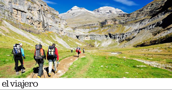
Route through the Soaso glacier cirque, in the Ordesa y Monte Perdido National Park.
M Ramirez alamy
4. The Trans-Pyrenees: 800 kilometers of high mountains
The Pyrenees that separate France and Spain are not as high as the Alps (their highest peak, at 3,404 meters, is the Aneto), but they are perhaps more splendid and diverse. For those who want to know the variety of this mountain range shared by neighboring countries, nothing better than undertaking
the great Trans-Pyrenees
, considered one of the most beautiful and challenging hiking routes in Europe. It crosses from west to east —or vice versa— the mountain range, passing through four autonomous communities and with a long stretch that runs through Andorra.
Traditionally, the route begins on the shores of the Cantabrian Sea, at
Cape Higuer,
in the Guipuzcoan town of Hondarribia, and ends in Catalonia, at the iconic
Cap de Creus
(Girona), the easternmost point of the Peninsula, north of the Gulf of Roses. It is a high mountain path, perfectly signposted with white and red GR11 markings, which encompasses landscapes of impressive and varied beauty. The numbers can be scary:
810 kilometers in length
, just over
78,000 meters of accumulated unevenness
and
44 or 46 stages
—Depending on the chosen variant—, each of which has a variable length of between 10 and 35 kilometers. However, behind these figures hides a route that crosses unforgettable places: dense forests such as the
Irati jungle
, the second largest beech forest on the continent; picturesque mountain villages where time seems to have stopped; jaw-dropping geological formations; lush valleys and legendary peaks such as
Monte Perdido
or
Aneto,
jewels in the crown of the Aragonese Pyrenees. All along the way we will find abundant fauna and changing landscapes. Essential stops are also the Aigüestortes i Estany de Sant Maurici National Park, studded with
beautiful lakes
, and the spectacular
karst canyons
of Ordesa and Monte Perdido.
There are travelers who face the route of the pull, for which it is necessary to reserve at least a month of time, but the most normal thing is to divide it into shorter sections.
It can be done, for example, by autonomous communities: Basque Country and Navarra are eight stages, from Irún to Isaba, but they have less unevenness than the following.
In Aragon there would be about 14 stages, which begin in the
valley of Hecho and Ansó
and end in the
refuge of Conangles
, already in Lleida, passing through the highest massifs of the entire mountain range.
The Andorran parenthesis represents three more stages and it is still necessary to cross the north of Catalonia, with very variable difficulty, until reaching the waters of the Mediterranean.
A cyclist makes a stop on the Senda del Oso, on the bridge that crosses the Valdemurio reservoir, in Asturias.
Victor Sanchez alamy
5. The Senda del Oso by the old mining railway (Asturias)
The old platform of a mining railway line has become
the most popular green path in Asturias
and the entire north of the peninsula. It has several attractions: it is very
well signposted
(with several rest areas and a multitude of information panels); the
unevenness is low
, as it runs along the same stretch that the train used to run; You have to cross up to 11 bridges over the
Llanuces, Picarós and Trubia rivers,
and you access the enclosure where some
brown bears
live
that can no longer be reintegrated into nature for various reasons. The route allows alternatives of different distances and is
ideal to go with children
. It crosses four councils:
Quirós, Santo Adriano, Proaza and Teverga,
which make up the so-called region of the Valles del Oso, as it is a refuge for one of the last populations of Cantabrian brown bear, one of the three species of brown bear in Europe.
The Senda del Oso has almost
60 kilometers
and can be traveled
by bicycle or on foot
.
It begins in
Turón
and reaches the
Huerta cave
, a karst cavity in the council of Teverga.
It follows the old route of the mining railway that ran through the Trubia valley but was abandoned in 1964. Now, the path winds through dense oak forests and rock walls.
In reality, there is not only one Senda del Oso, but two: halfway through a fork allows you to take the route to the
village of Santa Marina,
entering the heart of
the Las Ubiñas-La Mesa natural park
and crossing the
Valdemurio reservoir
by a bridge of wood.
We can rent a canoe and take a ride around the lake.
Overview of the town of Los Marines, in the Sierra de Aracena (Huelva).
Rob Cousins alamy
6. Sierra de Aracena, trails between hams and mines (Huelva)
In the north of Huelva, the
Sierra de Aracena
is a hiker's paradise, in the middle of a territory that is known for the production of the best hams in Spain and with such emblematic names as
Jabugo
.
In the middle of a landscape that combines forests, cultivated fields, meadows where cattle graze and agricultural activities, we also find good routes, such as the marked path, equipped with railings and well equipped with information panels, which takes us through the area. of
Corteconcepción
.
It is
13 kilometers
by a relief with few strong slopes that allow to know the most significant natural environments of this territory.
Spring, with the concentrations of flowers in the meadows, is the ideal time for this excursion.
In fact, in the Sierra de Aracena there are almost a thousand kilometers of itineraries that cross the entire Sierra de Aracena and Picos de Aroche Natural Park, and among which it is difficult to choose the best trail. There are two great options. In
Cortelazor
a circular route of almost 20 kilometers, relatively demanding, passes through areas with streams and ravines, between
lush forests of chestnut, holm oak and cork oak.
Another option is the so-called
Camino de Gimón Pérez
, which follows the old train line that carried the mineral from the Cala mines to almost Seville. It is a route almost close to the banks of the Huerva river, where it will not be difficult to come across a deer, a wild boar or a fallow deer that come to drink.
The cave of Cap de Barbaria, on the Balearic island of Formentera.
MELBA PHOTO AGENCY alamy
7. Formentera, from lighthouse to lighthouse (Balearic Islands)
The route that connects the
lighthouses of La Mola and Barbaria
, in small Formentera, is one of the greatest hiking challenges that can be done on the Balearic island.
It starts from the eastern end, on the most imposing cliff, which even awakened the fantasies of the writer
Jules Verne
, and reaches the western end, girdling Formentera's waist and covering a considerable distance, taking into account the reduced terrain.
It is a demanding route due to its length (more than
26 kilometers of walking
) and the
permanent exposure to the sun
.
The Cap de la Mola lighthouse has been shining since 1861 on the eastern coast of Formentera. In its century and a half of history, this place has gathered
dozens of anecdotes, real and legendary
, such as the one witnessed by the monument dedicated to Jules Verne at its feet. It is said that the French author was inspired by the island and in this specific place to write the adventure novel
Héctor Servadac
(1877)
.
The end point of the path is
Cap de Barbaria
, in the southernmost point of Formentera, in the middle of an
arid and breathtaking, almost lunar landscape
. From this enclave, on clear days you can see the African (or Barbarian) coasts. In addition, the area attached to the lighthouse is
full of caves
, in which it is not advisable to enter if you do not have a
fine sense of orientation.
The beech forest of La Tejera Negra, in Guadalajara.
Juan Carlos Marcos Martin alamy
8. Autumn in the beech forest of La Tejera Negra (Guadalajara)
In the north of the province of Guadalajara is
the largest beech forest in the Central System
, a natural space in the Sierra Norte that acts as a balm for the senses, especially in autumn, when it is tinted with an ocher color palette by the falling leaves. In addition, it is the same season in which the
bellowing of the deer
occurs
, one more reason to come to know this place. In the beech forest there are
two circular routes
, signposted with interpretive panels and beacons, to be done on foot: the
Senda de Carretas
(6 kilometers) and the
Senda del Robledal
(17 kilometers, with the possibility of linking it and continuing along Carretas). Overall, this circular route from the Sierra Norte natural park car park is simple and marked, although it has more unevenness than it may seem at first glance. The only problem is its popularity, which makes it excessively crowded in October and November. Parking is paid and must be reserved at hayedotejeranegra.castillalamancha.es
The complement to the visit to the beech forest is to get closer to the so
-
called
black towns
.
For example, to
Majalrayo
, to the south of the protected area, a very interesting sample of popular architecture, which it shares with several towns in the
Segovian Sierra de Ayllón
built with slate, with a certain bucolic and mysterious air, with their houses grouped together to combat the cold.
Almost a hundred towns in
Guadalajara, Madrid and Segovia
show this type of black architecture and have proposed that it be declared a world heritage site.
Ruins of the castle of the town of Siurana.
Gerold Grotelueschen Alamy
9. Siurana and surroundings: the most beautiful town in Catalonia
For many, Siurana is one of the most beautiful towns on the Peninsula, and it is probably the most beautiful in Catalonia. This town nestled on top of a precipice dominates the Priorat region (Tarragona) from above and brings us closer to the walls of the
Serra del Montsant
, which hide a labyrinth of paths between forests and vertical walls that are one of the
main schools world climbing
. On the trails you can see the insurers tightening the ropes for others to climb and on the walls, shouts of effort and encouragement. Almost all roads lead to the foot of some of the most difficult and famous roads.
But there are also much simpler alternatives and paths for everyone. Siurana is at the end of a road that climbs to the top of an imposing vertical cliff. Its cobbled streets and well-kept houses are worth a visit, but also
the church's bell tower
, right on the edge of the precipice, gives the town a unique look. From there
a 12-kilometer route
starts
that can be completed in four hours. The first section is a descent to
Cornudella del Montsant
, a reference town, between forests and a certain atmosphere of mystery. The second part is flat and completely surrounds the lake generated by a dam, up to the tail where some
bathing pools
open
very popular in the area.
And finally, a difficult climb along narrow paths that will take us back to Siurana, passing through one of the most beautiful places in these mountains,
La Trona
, a curious viewpoint to enjoy a huge panoramic view of the area.
The Ebro river, as it passes through the Hoces del Alto Ebro y Rudrón natural park, in Burgos.
M Ramirez alamy
10. Through the embedded meanders of the Ebro River Canyon (Burgos)
We usually imagine the Ebro wide and mighty passing through Zaragoza, or ending in the shape of a delta in the Mediterranean. But there is another Ebro, the youngest,
the one that passes through the north of Burgos
, when it has just left its source in Cantabria and is collecting the frequent and copious rains from the north. A river that is making its way between rocks that at first glance seem difficult to drill, carving the territory, leaving incredible landscapes, drawing spectacular meanders and gorges like those that give rise to the Hoces del Alto Ebro and Rudrón natural park: 46,000 hectares of karst terrain accompanied by a
perfect riverside forest, with beech, maples, alders, gall oaks, willows, poplars and holm oaks
.
A very simple circular route, 12 kilometers long, allows you to enjoy these landscapes, starting from the Burgos town of
Valdelateja,
in the Páramos region, and taking about three and a half hours. Much of the excursion follows the traditional paths between neighboring towns, used by shepherds and those who took advantage of the forest to get
wood, mushrooms, medicinal herbs or charcoal
. And if we are left wanting to walk more, the
GR99
long-distance
trail
completes 25 kilometers between
Orbaneja del Castillo
and
Valdelateja
, another way to get into the natural beauties of this unique territory.
Find inspiration for your next trips on our Facebook and Twitter and Instragram or subscribe here to the El Viajero Newsletter.