The Observatory said at 7 a.m. that according to the current forecast path, the tropical depression will continue to approach the coast of Guangdong and strengthen slightly.
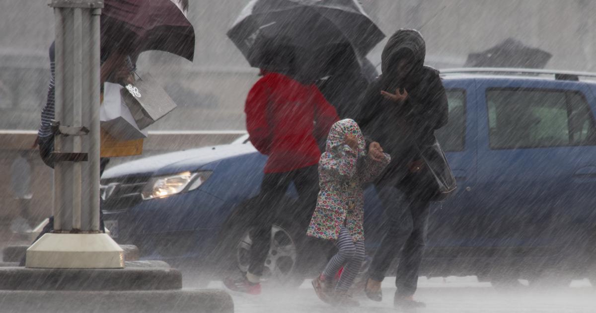
Affected by its outer rainbands, there will be squally showers and thunderstorms in Hong Kong today (September 9), with heavy rain at times.
Strong winds are blowing offshore and highlands, and the general winds will intensify further later.
The Observatory reissued the No. 3 Strong Wind Signal at 11:25 am today.
The Observatory continued that the No. 3 typhoon will remain at least until 6 p.m. today, and whether a higher signal will be issued thereafter will depend on changes in the intensity of the tropical depression and local wind changes.
As for the Macao Meteorological Bureau, the typhoon signal No. 3 was issued at 11:30 in the morning.
Observatory website pictures
August 9th wind report
[11:45] The No. 3 strong wind signal is now in effect, and the average wind speed in Hong Kong is expected to be 41 to 62 kilometers per hour.
The Observatory said that at 12:00 noon, the tropical depression in the central part of the South China Sea gathered about 580 kilometers south-southwest of Hong Kong, and is expected to move northward at a speed of about 18 kilometers per hour, moving towards the area from western Guangdong to Hainan Island, and gradually intensifying.
[11:25] The Observatory said that the No. 3 strong wind signal was issued at 11:25 in the morning, and the average wind speed in Hong Kong is expected to be 41 to 62 kilometers per hour.
Typhoon No. 3 will remain at least until 6 pm today.
Whether a higher signal will be issued later will depend on the changes in the intensity of the tropical depression and local wind changes. The Observatory will closely monitor the development and movement of the tropical depression.
The Observatory also pointed out that the broad outer rainbands associated with the tropical depression are affecting the northeastern part of the South China Sea and the coast of Guangdong.
There are showers, thunderstorms and violent gusts in Hong Kong today. The rain is sometimes heavy.
[10:55] The Macao Meteorological Bureau stated that it will change the No. 3 typhoon signal at 11:30 today, and it is predicted that the local wind will increase.
As for Macau, the probability of changing to Typhoon Signal No. 8 this evening is medium.
As for the Mainland's Central Meteorological Observatory, the latest typhoon alert at 10:16 a.m. stated that the intensity of the tropical depression has been upgraded to a tropical storm, and the maximum wind force in the center has increased to 65 kilometers per hour.
(Photo from the website of the Macao Geography and Meteorological Bureau)
[10:23] The Leisure and Cultural Services Department announced that due to strong waves and inclement weather, Tung Wan Beach and Lower Cheung Sha Beach in Cheung Chau in the outlying islands, and Samsung Beach, Silverstrand Beach and Clear Water Bay in Sai Kung District A red flag has been hoisted at Second Bay Beach, indicating that swimming there is dangerous, and members of the public should not swim there.
[09:47] The Education Bureau announced that since the Hong Kong Observatory will consider changing the Tropical Cyclone Warning Signal No. 3 between 10:00 a.m. and 1:00 p.m., kindergartens, schools for children with physical disabilities and schools for children with intellectual disabilities will be closed today. Keep school buildings open while implementing contingency measures to take care of students who have returned to school and arrange for students to return home when it is safe to do so.
Parents do not need to rush to school to pick up their children home.
[09:45] The Observatory said that at 9:30 am, strong gusts of about 70 kilometers per hour were recorded in Cheung Chau.
[08:45] According to the Observatory, at 9:00 am, a tropical depression in the central part of the South China Sea gathered about 590 kilometers south-southwest of Hong Kong, and is expected to move north or north-northwestward at a speed of about 18 kilometers per hour, moving toward the west of Guangdong to Hainan Island area, and gradually strengthened.
The Observatory expects squally showers and strong squally thunderstorms in Hong Kong. The rain will be heavy at times. During the day, the easterly wind will be clear and strong, and the wind will be further strengthened later.
The sea has big waves and swells.
[08:00] The Observatory issued a special weather warning, referring to the extension of the thunderstorm warning until 10:30 am today. Strong squally thunderstorms are expected in Hong Kong, and violent gusts of up to 100 kilometers per hour or more will hit Hong Kong.
[07:45] The Observatory said that it will consider changing the No. 3 strong wind signal between 10 am and 1 pm today, depending on local wind changes.
According to the Observatory, according to the current forecast path, a tropical depression will continue to approach the coast of Guangdong and strengthen slightly.
Affected by its outer rainbands, there will be squally showers and thunderstorms in Hong Kong today, with heavy rain at times.
Strong winds are blowing offshore and highlands, and the general winds will intensify later.
▼The Observatory issued a yellow rainstorm warning on August 3▼
+3
[04:45] The Observatory said that the tropical depression is about 650 kilometers south-southwest of Hong Kong. The highest sustained wind speed near the center is 45 kilometers per hour. It is expected to move northward at a speed of about 18 kilometers per hour. From the west of Guangdong to Hainan Island, it gradually intensified into a tropical storm. The maximum sustained wind speed near the center rose to 85 kilometers per hour, close to the level of a severe tropical storm.
(Maximum sustained winds rose to 90 km/h near the center).
[03:45] According to the Observatory, a tropical depression in the central part of the South China Sea is about 660 kilometers south-southwest of Hong Kong and is expected to move northward at a speed of about 18 kilometers per hour. According to the current forecast path, the tropical depression will be close to the Hong Kong maintains a distance of more than 500 kilometers. The No. 1 Standby Signal will be maintained until 10 am this morning, and then the No. 3 Strong Wind Signal will be considered depending on the wind changes in Hong Kong.
Hong Kong will be affected by the outer rainbands of the tropical depression today, with squally showers and thunderstorms, with heavy rain at times.
There will be large waves and swells on the sea surface, the public should stay away from the shore and stop all water activities.
[03:40] The Observatory issued the No. 1 alert signal.
Typhoon | The Observatory issued a typhoon signal No. 1 in the early morning and maintained until 10 am this morning
The Macao Meteorological Bureau predicts that the chance of typhoon No. 3 being issued today is high.
▼The situation under the tropical depression No. 1 typhoon on August 4▼
+4
Today's offshore and highland winds reach No. 3, and the typhoon will intensify to Category 8 gale force tomorrow
The Observatory updated the nine-day weather forecast at 0:00 a.m., which is roughly similar to the forecast at 4:30 p.m. yesterday. It means that due to the influence of its outer rainbands, there will be squally heavy showers and thunderstorms in the northern part of the South China Sea and the coast of Guangdong in the next one or two days. There are swells.
However, the Observatory said that due to the influence of its outer rainbands, there will be squally, heavy showers and thunderstorms in the northern part of the South China Sea and the coast of Guangdong in the next two or three days. The wind will be quite strong and there will be swells in the sea. The shore blows at level 6 (strong wind), and later it reaches level 7 (strong wind) in the highlands.
That is, the wind force of the No. 3 typhoon (level 6 and 7) will also reach level 6 early tomorrow, and the offshore and highland will reach level 8 (strong wind), which is the wind force of the No. 8 typhoon.
The typhoon | The Observatory issued the No. 1 typhoon in the early morning, and the No. 1 typhoon was maintained until 10:00 this morning | The Macao Meteorological Bureau of the Observatory was the first to issue a forecast path map tonight to hit the wind | The rain in Hong Kong will continue until the wind blows next week. The Observatory expects that the No. 1 typhoon will be issued as soon as tomorrow and will cross the northern part of the South China Sea on Tuesday and Wednesday. Wind|The Observatory expects multiple factors to be favorable