The United States rescues illegal immigrants from the sea before being hit by Hurricane Ian 1:38
(CNN) --
People woke up this morning with a sense of dread: Hurricane Ian could be the storm Florida's west coast has always feared, especially Tampa.
One of the cities most vulnerable to hurricanes could be facing its worst case scenario: Tampa is now under a hurricane and storm surge warning, and this is just the beginning.
"We tell people, even if they're lifelong Floridians like me, that this is something we haven't seen in our lifetime and we definitely have to take it seriously," said Rick Davis, a meteorologist with the National Weather Service in Tampa. .
Tampa hasn't been directly hit by a hurricane in 100 years, Davis said.
It has been on the verge of it and has had several brushes with strong storms, but this one is different.
"They (locals) may have the perception of having been through a bad storm. But in reality, the Bay Area has been spared more often than not," Davis said.
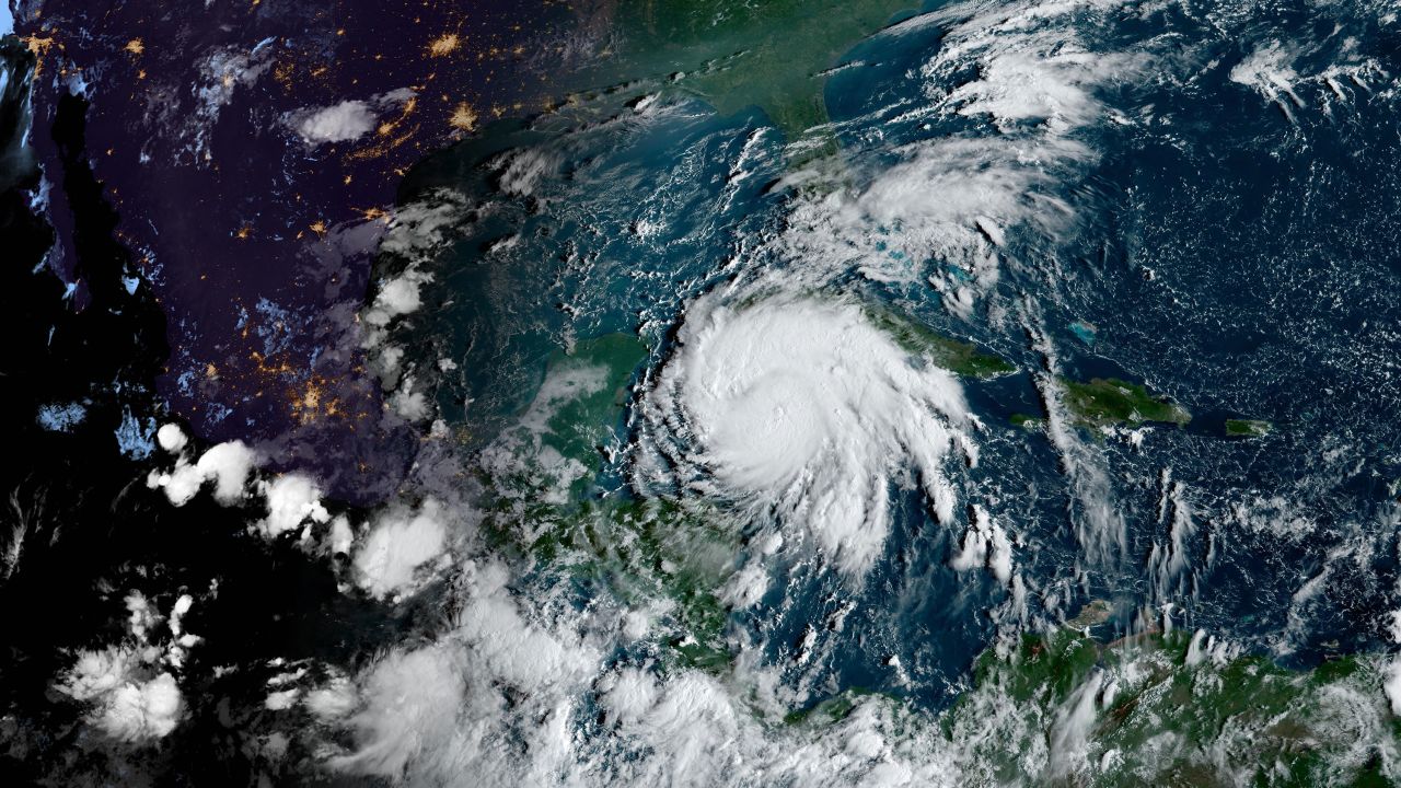
Right now, Ian is a category 1 hurricane with winds of 128 km/h and gusts even higher.
advertising
Hurricane Ian Breaking Live: Track, News, and Arrival in Florida
The storm is expected to strengthen rapidly today as conditions have been set for it to thrive.
The storm will impact western Cuba tonight and Tuesday as a Category 3 hurricane.
The storm surge could raise the water level by up to 4 meters and bring more than 300 mm of rain to the island.
"These rains can produce flash flooding and landslides in areas of higher ground over western Cuba," the hurricane center warns.
As the storm approaches northern Cuba, forecast models should have a better understanding of what happens next.
We know that the environment surrounding the storm will be one that helps it maintain its strength, but the question is exactly where it will make landfall.
"Regardless of Ian's exact track and intensity, there is a risk of life-threatening storm surge, gale-force winds and torrential rains along Florida's West Coast and Northwest Florida by the middle of this week," the hurricane center said.
Storm surge is a real threat
While there is still uncertainty surrounding Hurricane Ian, the National Hurricane Center is currently forecasting a storm surge of between 60 and 120 inches in Tampa Bay, so residents should be prepared.
"Tampa Bay is a pretty small body of water relative to everything else, but the water will accumulate more and more, and with the southeasterly winds, there is nowhere for the water to go as the storm moves." slowly," Davis said.
"So it continues to collect water in downtown Tampa, which is very vulnerable to storm surge flooding. That's definitely a concern for us."
Davis hopes his region will take this storm seriously, prepare and heed the warnings that are in place.
Ian will be strong, there is no doubt.
"We had the weekend to prepare, so I hope people have prepared and are finishing preparations, because we expect a life-threatening storm surge in the next 48 to 60 hours," Davis said.
"So finish those preparations, because this is going to be a pretty significant event for the Tampa Bay area."
Florida authorities urge residents to prepare for Tropical Storm Ian, which is expected to become a major hurricane before reaching Cuba
So far, tropical storm force winds are forecast to reach South Florida as early as Tuesday, with rain totals ranging from 4 to 6 inches and nearly 18 inches of rain farther north, winds with force hurricane and, as mentioned above, life-threatening tidal surges.
Tampa does not have to be hit directly for catastrophic flood damage to occur.
Tampa Bay is extremely vulnerable to storm surges, because the water that is pushed into the bay has nowhere to go.
"Even in small storms we can get coastal flooding in the Tampa Bay area, Bayshore Boulevard, and we're talking pretty weak storms, so we can expect that with a stronger storm, which is expected to be much closer and slow-moving, it will continue to collect water in areas along Tampa Bay and in St. Pete,” Davis said.
Why Meteorologists Say Ian's Exact Track Is Still Uncertain
Although we know that Ian will be strong and have a tremendous impact, there is still uncertainty in the storm.
Unfortunately, most scenarios are bad for the Tampa Bay area, because it's so vulnerable.
But uncertainty in the forecast could make a difference in how severe the devastation is.
"Weather models are only as accurate as the information put into them," said CNN meteorologist Chad Myers.
"NOAA has been doing everything possible, including additional launches of weather balloons and flights of hurricane hunters, to increase the accuracy of this data."
Here are the different forecast scenarios depending on which model is chosen.
There is still uncertainty in Ian's trajectory.
The truth is that the accuracy of the forecasts decreases from days three and four.
The forecast has shifted slightly from west to east over the weekend, pointing to different points along the Gulf Coast.
So it's impossible to say at this point exactly where the storm will make landfall, but we do know that the effects will extend far beyond that site: this will be a big, strong storm.
The hurricane center also noted uncertainty in its discussion of forecasts this morning.
The models agree on what will happen in the next 48 hours, but beyond that, there is much to discuss.
European forecast models are "on the eastern side of the orientation and show a track very close to or over the west-central coast of Florida," the hurricane center said.
While other forecast models are "on the western side with a trajectory towards the Appalachian Bay".
While this may not seem like a huge disparity to some, this could mean the difference in someone getting 100+ mph winds, or a breezy day, or someone getting nearly 10 feet of storm surge, or next to nothing. , That is a big difference.
"An even bigger concern is the slower forward motion than is forecast," the hurricane center said.
"This would likely prolong the impacts of storm surge, winds and precipitation along the affected portions of Florida's west coast, although the roughly parallel track to the coast still makes it difficult to pinpoint exactly which locations will experience the most severe impacts." ".
The bottom line is that there are some certainties and some uncertainties, so we need to prepare for the worst and be ready for anything with Ian.
"It has to be stressed again that there is still significant uncertainty in Ian's track, especially in the three to five day time frame, and users should not focus on the track forecast details for longer time ranges. long," the hurricane center said.
-- Judson Jones and Haley Brink contributed to this report.
Hurricane