
Spring time until Friday but already in the evening the
Carnival Cyclone
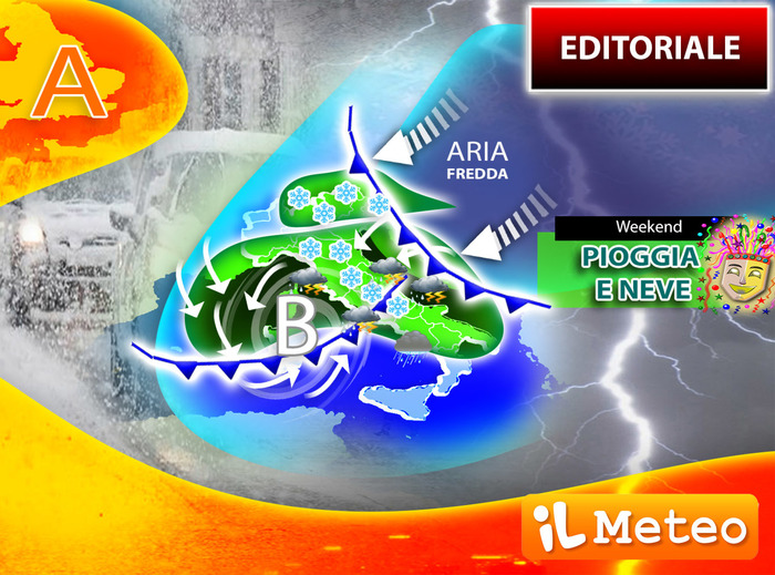
could arrive which will bring winter and
snow back to Italy even at low altitudes
.
Lorenzo Tedici, meteorologist of the site www.ilmeteo.it, confirms the formation of a deep cyclone on the Tyrrhenian during the weekend, due to the descent from the Russian steppes of polar air.
The surprises of Carnival, therefore, also from climatological statistics, are not lacking.
In recent days, in fact we have passed from winter to spring and back.
The weather was extreme with unseasonal summer hailstorms, severe thunderstorms, storm surges and hurricane winds.
The winds were the protagonists of this beginning of the week, two days that made us plunge back into a phase of winter mold.
There have been hurricane gusts in Italy, as defined by the scientific terminology of
the Beaufort scale:
according to the British Admiral
Francis Beaufort
, winds above 118 km / h are defined as hurricane.
Between Monday and Tuesday
: in the Turin Alps, at 3200 meters, 173 km / h were reached;
on Monte Cimone, in the Emilian Apennines, 150 km / h;
even more noteworthy are the 163 km / h reached in Sardinia and the 100 km / h in Ponza.
In short, all of Italy was lashed by strong and cold winds, with the exception of the north-west where, due to the compression, the strong Foehn wind was hot and pushed the thermometer up to 18 ° C in Milan, for once again in this crazy winter 2021-22.
But let's see
in detail the forecasts
for the next few days:
Wednesday 23
.
In the north: clear skies.
Middle: good weather.
In the south: predominance of sunshine, still strong winds.
Thursday 24
.
In the north: rising clouds.
Center: increasing cloudiness.
In the south: the sun is the protagonist.
Friday 25
.
In the North: worsens in the Northeast with showers.
Center: rising clouds.
South: good weather.
Trend.
weekend
with cyclone and winter bad weather especially in the Center-South.