
After 4 years it is finally inaugurated: the perfect family route for Passover
Near Mount Tabor in the Lower Galilee, a 3 km hiking trail was recently arranged with an investment of about 750,000 shekels, which has been worked on for 4 years. So what awaits you in Nahal Hashiva? Flowing water, bridges, seating areas, spring blooms and even a section for carts. Perfect for families this Passover
Ziv Reinstein
06/03/2022
Sunday, 06 March 2022, 11:56 Updated: 12:07
Share on Facebook
Share on WhatsApp
Share on Twitter
Share on Email
Share on general
Comments
Comments
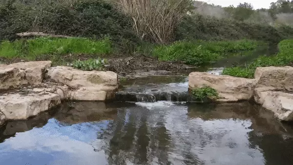
Nahal Hashiva in the Lower Galilee (Photo: Drainage Authority and Southern Jordan Streams)
For the past four years, they have been working on the restoration of Nahal Hashiva (Wadi al-Midi) in the Lower Galilee, named after seven Palmach fighters who were killed in the Nahal War during the War of Independence
. A spherical book to the Bedouin village of Shibli and connects to Nahal Tavor south of the Gazit junction. It is about eight kilometers long, and in winter there is a flow of water from the Nazareth Mountains and later in the year .
The creek channel was kept natural on the slopes of the mountains, but during it in the agricultural areas was arranged a canal that changed its completely natural character.
Nahal Tavor and its tributaries are an important ecological corridor connecting the Jordan Valley with the Lower Galilee, and Nahal Shiva as mentioned has now been restored, restoring its natural appearance and vegetation and developing it into a meeting place for the residents of the area, but not only of course,
The new section, about 800 meters long, connects and completes a full path that is about 3 km long, including seating areas and a shading pergola, between Kfar Tavor, Shibli Umm al-Janem and the Kadouri agricultural youth village, through Nahal Hashiva to Nahal Keshet .
More on Walla!
The Hot Springs Guide
A classic hike for a sunny day in winter: skips between cascading waterfalls in the north
The 15 most beautiful family trips in Israel
The signs before and during a heart attack that you may not have known about - how to identify and what to do?
Views of Mount Tabor in the background of the trip.
Nahal Hashiva (Photo: South Jordan Drainage and Streams Authority)
Map of the Nahal Hashiva route (Photo: South Jordan Drainage and Streams Authority)
Bridges over the river have been built (Photo: South Jordan Drainage and Streams Authority)
The stream flows from the springs of springs that it collects along the way (Photo: Drainage Authority and Southern Jordan Streams)
At the Ein Zetuta junction, have you been?
As part of the work, which began in June 2018, the first section was launched with funding from Rami (Israel Land Authority), from the Ein Zetuta junction (a lovely corner that was also restored last year) in the direction of Kadouri. The stream and its arrangement, expansion, scenic architecture, creeks and
stalagmites
, while maintaining a drainage section of the stream, in order to direct the flow of rainwater to the occurrence of a stream.
Road No. 65, which included hiking trails, a bridge to cross the creek, seating areas, etc. As part of the work to connect the area's communities to the creek, a trail connecting Kfar Tavor to Nahal Hashiva was inaugurated about a year ago through a beautiful canal adopted by Kfar Tavor youth. The fourth inaugurated now.
More on Walla!
The stream, which has been neglected for years, will be rehabilitated with the help of the Bedouin residents
To the full article
Along the creek is an accessible concrete path (Photo: South Jordan Drainage and Streams Authority)
Spring blooms accompany hikers in the river (Photo: South Jordan Drains and Streams Authority)
Restoration work has been carried out on the plant landscape and the biological diversity in the river (Photo: Drainage Authority and Southern Jordan Streams)
One hundred trucks emptied garbage from the creek
As part of an ecological, environmental and development restoration project in the river, with an investment of NIS 750,000 by the Israel Land Authority's Open Space Preservation Fund, four years of restoration of the plant landscape and biodiversity, garbage removal by one hundred trucks, accessibility and area development Nature and heritage that includes observation corners and seating areas.
The project was carried out under the leadership of the Lower Galilee Local Authorities, Kfar Tavor and Shibli Umm al-Janam, South Jordan Drainage and Streams Authority, Kadouri Agricultural Youth Village, Maycom Corporation (Lower Galilee Water and Sewage Corporation), Israel Land Authority - Land Conservation Fund Open, the Ministry of Environmental Protection and the JNF.
The stream flows in the area of the settlements of Kfar Tavor, Shibli and Umm al-Janam (Photo: Drainage and Streams South Jordan)
Route route from the air (Photo: South Jordan Drainage and Streams Authority)
Hikers in the creek.
The linear route is 3 km long (Photo: South Jordan Drainage and Streams Authority)
The route
The path starts at the end of Tavor Street in the Alonim neighborhood in Kfar Tavor, and a wooden sign pointing to the path marks its beginning.
From here a magical channel descends to Nahal Hashiva (Wadi al Midi), where you will meet a concrete path along the entire stream.
Further down the road is a wooden bridge leading to the pergola and an explanatory sign.
Back on the road you will lead all the way out of the village of Shibli, as you walk at its foot all the way.
Then cross the road and continue on the concrete path, where you will meet mosaic explanatory signs about the animals in the creek created by Shibli and Kadouri students.
Next you will reach another wooden bridge leading to a shady picnic area.
When you return to the path - it will become a path of pickled gravel (mud) that winds along the stream between the trees and the rich vegetation that the stream longs for.
The path will continue up the gorge until the meeting with Nahal Keshet and along it, a shaded path with a variety of seating areas that continues up to the foot of the Kadouri agricultural youth village, where you will reach a mosaic sign and a pergola - an outdoor classroom used by Kadouri school students.
Along the path there are seating areas and parking lots, including places nurtured by the children of the area, who embrace the creek.
How to get there:
Write in Wise: Parking Alonim neighborhood, Moran, Kfar Tavor.
https://waze.com/ul/hsvc1vztzg
Nahal Keshet parking lot: https://www.google.com/maps?q=32.6994505,35.4090846&z=17&hl=en
Tourism
Excursions in the country
Excursions in the north
Tags
Streams
Excursions in the country
The Lower Galilee
Tavor mountain
Shibli
Route


/cloudfront-eu-central-1.images.arcpublishing.com/prisa/IGZ7GOCXZ5GUPAQ2HWGK6Z76BU.jpg)