
Keren Ein Gev: The amazing route that leads from the Golan to the Sea of Galilee
After two years of closure due to safety issues, the Ein Gev Keren Trail in the southern Golan was opened and re-marked, offering not only a spectacular view of the Sea of Galilee, but also a visit to an old Jewish settlement that survived until 1920, a small spring and remnants of spring blossoms
Walla!
Tourism
10/05/2022
Tuesday, 10 May 2022, 08:32 Updated: 08:39
Share on Facebook
Share on WhatsApp
Share on Twitter
Share on Email
Share on general
Comments
Comments
Cinnabar Beach on the Sea of Galilee (Photo: Yoni Dotan, Kinneret Cities Association)
Spring brings exciting new things to the Golan.
Everything is blooming, green and flowing - new puppies, chicks and chicks emerge into the natural world, and tens of thousands of hikers come to walk among the Golan trails, whether on the Golan Trail or in one of the dozens of beautiful water points scattered in the area.
In honor of the spring, the Nature and Parks Authority opened the Ein Gev Foundation route, after two years of being closed due to safety issues, and even re-marked the trail.
The Keren Ein Gev route is a route in the southern Golan Heights that characterizes the landscape, soil and rock of the area, with the trail starting in basalt and passing in half to the ancient limestone below it.
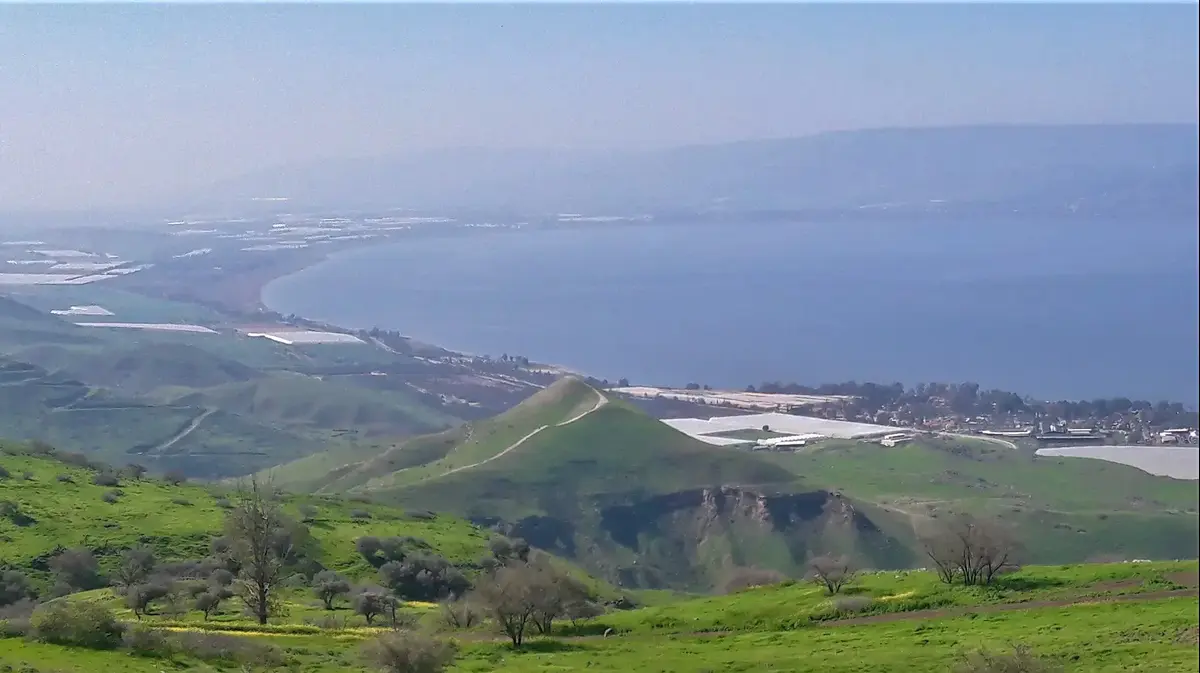
The route is intended for well-wishers or well-to-do families, it is not circular (about 6 km) and begins at the beautiful Mitzpe Ofir, near Moshav Givat Yoav. Mitzpe Ofir overlooks the Sea of Galilee and Nahal Samek The place was established, developed and maintained by Jimmy, Ofir's Spring.
More on Walla!
Where it is forbidden to make noise and what is free: a guide to the shores of the Sea of Galilee
To the full article
More on Walla!
Spring gift: All maps of the Israel Trail for free download
Naomi Pool: How did we not know this place in the Golan ?!
Abroad, but ours: the most anti-corona nature vacation of the summer
Defeat the pain without fear: B-Cure laser in a trial operation at an unprecedented price
The route is intended for well-wishers or well-to-do families.
The Sea of Galilee from the Ein Gev Foundation Trail (Photo: Walla !, Ziv Reinstein)
There is not much shade for the Ein Gev beam, take advantage of the trees on the way (Photo: Nature and Parks Authority, Naama Mansfeld)
The Keren Ein Gev trail begins here.
Mitzpe Ofir (Photo: Walla !, Ziv Reinstein)
A road story
Stairs ascend from the left end of Mitzpe Ofir, with blue trail markings, and this is where the route begins.
March on the cliff and pass a cattle gate.
Along the cliff you will find old Syrian bunkers, which illustrate the control that the Syrians had until 1967, from the Golan Heights over the kibbutzim of the Jordan Valley.
After a short and nice walk on the cliff you reach olive trees, where you can stop for a short break and where the path also turns right, down sharply.
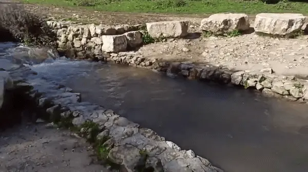
Then you meet the Golan Trail and with it turn left to Bir a-Sagom (Old Bnei Yehuda), a small spring and an inconceivable historical story, about Jewish families from Safed who tried to cling to the land, east of the Sea of Galilee, at the end of the 19th century (1920-1886).
It is also a great place to take a break.
The old trough and the spring house still stand on the site.
Near the spring basalt benches in the shade of the trees and the spring water are piped into the small stream, for the wildlife of the reserve.
After the break, separate from the Golan Trail, and continue walking on the blue trail.
Now, the path passes over a low level from the cliff on which you walked before, and in front of you will be the highlight of the route - the pointed corner of the back eye.
The path you will walk on does not have a lot of shade.
One tree will be waiting for you on the way with a view of the horn, and after a short break continue on the path until a sharp turn to the right, where you can clearly see the change in rock between basalt and limestone.
Get off here carefully!
There is a deterioration of stones, and if necessary you should get down on the buttocks.
Then you will reach the saddle that connects the plateau to the corner of Ein Gev, where huge carpets of thorny boat will wait - not a Golani plant at all, which indicates the replacement of the rock, the replacement of the soil, and consequently the vegetation.
A sign on the road, explaining the old Bnei Yehuda settlement (Photo: Nature and Parks Authority, Naama Mansfeld)
The route passes between basalt rocks and limestone (Photo: Nature and Parks Authority, Naama Mansfeld)
The highlight of the route - the pointed Ein Gev Foundation (Photo: Nature and Parks Authority, Naama Mansfeld)
And suddenly - a lone tree with an amazing view
You have reached the foot of Keren Ein Gev.
A green path will climb with you back and forth to the edge of the corner, for observation, and from there you will descend back to the junction and the blue path.
Surround the horn to the south, to the left of the horn, and see beautiful and well-designed hills, signs of animals visiting the trail at night, butterflies and sniffing stations of Israeli deer - points to which the male deer returns to mark territory with its droppings, which look like coffee beans.
After about 40 minutes walk you reach the other end of the foundation.
This is the descent that was closed due to rock degradation and soil erosion, and now we are waiting for the area to recover and the vegetation to return.
The process will take years so it is important not to climb, and let nature do its thing.
Pass cattle and walk on a wide dirt road.
And suddenly - a lone tree with an amazing view.
In the lone tree, the path leaves the wide dirt road for a narrow and tree-dotted descent, to another cattle crossing, from where you continue with a narrow descent to the cemetery of Kibbutz Ein Gev.
This is the end point, where you leave a pick-up vehicle or walk a little to the Ein Gev junction.
The route can only be done during the day (Photo: Nature and Parks Authority, Naama Mansfeld)
Otto, everything will be yellow ... the view from the path (Photo: Walla !, Ziv Reinstein)
Smell stations of Eretz Israel deer on the trail (Photo: Nature and Parks Authority, Naama Mansfeld)
The Haon Cliffs Nature Reserve was declared in the 2000s and preserves a unique and wide area cell, which allows wildlife to move between different habitats, between the Sea of Galilee and the Golan Heights and back, and wild plants to show their diversity between the rocky and climatic areas of the Golan Heights.
The route can only be done during the day.
At night the reserve is closed to wildlife and also the safety of hikers.
Tourism
Excursions in the country
Excursions in the north
Tags
Excursions in the country
The Sea of Galilee
Ein Gev
The Golan Heights


/cloudfront-eu-central-1.images.arcpublishing.com/prisa/S7ERVSCT4FUVX6R7TUVBDNTH5Y.jpg)


