Directly from Ukraine
, fresher and drier air
will fall on Italy over the next few hours and will cause a new increase in instability towards the North-East and the Center-South.
Against the drought in the North-West even this disturbance will not bring relief, against the African heat of the last few months it will be a cure-all: the
temperatures
will remain
pleasant
, not excessive, at least until Saturday 13 August.
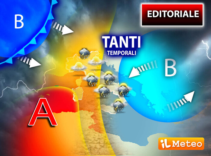
The fresh Ukrainian air will be associated with a 'cold drop in altitude', a closed area of low pressure, which will slide towards the Adriatic sector, particularly from tomorrow, also involving the entire Balkan area.
Andrea Garbinato, editor of the site www.iLMeteo.it, therefore points out the possibility of
new storms
in the next few hours
on the eastern Alps
while the capricious weather will continue on the lower Tyrrhenian: in summary we will have showers in the North-East, in the evening locally also in the plains, and sometimes intense showers between Lower Lazio, Campania, Basilicata, Calabria and Sicily.
Tomorrow we will still find temperatures slightly below the average for the period and thunderstorms in the same areas;
on Saturday the showers will be concentrated on most of the South and locally in the Center between Molise, Abruzzo and lower Lazio.
In summary,
the current Summer Crisis is confirmed
with frequent showers, especially in the afternoon, but we can enjoy acceptable temperatures.
Sunday 14, the eve of August 15th, the Ukrainian cold drop will move towards Greece and Bulgaria with the last storms, even intense ones, expected until morning only on Puglia, Calabria and Sicily;
we will have good weather elsewhere, even warmer.
Finally we come to
Ferragosto : at the moment the
Atlantic disturbance
is confirmed
incoming from France which could bring rains to the North-West and part of Tuscany, locally some showers could also reach the North-East.
We used the conditional as the models scaled back the expected half-month worsening;
unlike the first projection (towards almost autumnal conditions) it is possible that,
after August
15th , a
new hot joke of Summer 2022 will arrive:
from the Crisis to the Explosion of an exceptional heat.
As if to say the African fire still smolders under the ashes, but we'll talk about it again, in the meantime let's enjoy much more pleasant thermal values but pay attention to thunderstorms.
IN DETAIL
Thursday 11
In the North: slightly or partially cloudy skies.
In the Center: less hot, thunderstorms still on Lazio, and then in Sardinia.
In the South: severe storms over Campania, Basilicata, Calabria and Sicily.
Friday 12
In the North: unstable weather in the North-East, elsewhere by evening.
In the Center: thunderstorms over Lazio, Abruzzo, in the evening also in Tuscany.
In the South: bad weather with showers and thunderstorms, especially in the afternoon.
Saturday 13
In the North: sunny.
In the Center: local showers between Abruzzo, Molise and Lazio, sunny elsewhere.
In the South: scattered showers and thunderstorms, especially in the afternoon.
Trend: prevalence of sun on Sunday except for showers in the extreme South. August 15th unstable in the North and in Upper Tuscany, prevalence of sun and heat elsewhere.
Possible new African heatwave later.