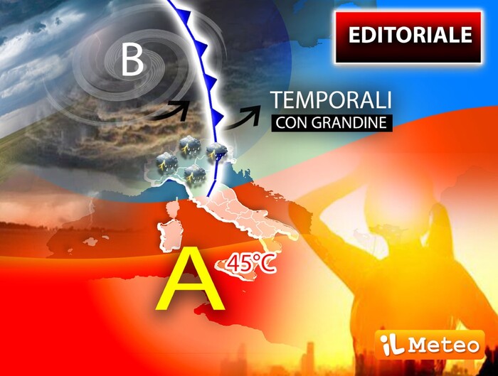
45
° C expected in Sicily
and storms in the North.
A disturbed area of Atlantic origin, in fact, is reaching our country, causing a progressive significant
deterioration
in the
north
and part of the
center
, starting from the north-western regions, with widespread
phenomena
, mainly
storms
, capable of giving rise to
storms
, which may also be associated with
violent gusts of wind
.
This was announced by the
Civil Protection
.
Based on available forecasts, the Department has issued a warning of adverse weather conditions.
The notice foresees widespread rainfall
in
Piedmont
and
Lombardy
from the afternoon-evening today
.
Moreover, from the early hours of
Thursday 18 August
, widespread rainfall is expected, predominantly of downpour or thunderstorm character, on
Liguria
,
Emilia-Romagna
and
Tuscany
, in progressive extension to the autonomous provinces of
Trento
and
Bolzano
,
Veneto
and
Friuli Venezia Giulia
.
The phenomena will be accompanied by showers of strong intensity, frequent electrical activity,
hailstorms
and strong gusts of wind.
On the basis of the expected phenomena, an orange alert
in Lombardy and Veneto, a
yellow alert
on most of the central-northern regions
was assessed for Thursday .
THE METEREOLOGIST'S POINT
A disturbing scenario that will begin in a few hours and will have the peak of intense phenomena and African temperatures between Thursday 18 and Friday 19 August.
Italy
will be
divided
in two
, clearly, between
bad weather
and the
sixth African heat wave
: a complex, difficult picture, with the arrival of the
first Atlantic disturbance
after
many months of drought in the North
, and with the recall (due to of this perturbation) of a very hot stream from Tunisia.
Storm phenomena are expected from the afternoon to start from the North-West, gradually moving towards the rest of the north on Thursday when part of the Center will also be affected, in particular Tuscany, Umbria and locally Marche and
Lazio
.
In the South, as mentioned, with the sixth African heat wave we will also reach 45 ° C in the shade in Sicily, an exceptional value also considering the period: we are almost at the end of Summer 2022.
Lorenzo Tedici
, meteorologist of the site www.iLMeteo.it, confirms that the combination of storms in the North and heat in the South is the
norm during the first autumn months
: very often between September and October we hear about "Italy divided in two", "Well this year we are early. The precipitation will be associated, in the North, with a
significant drop in temperatures
, especially from tomorrow, from gusts of wind, storms and hail. The bad weather will also affect the Center with the same characteristics. Thursday and Friday, while
in the South the temperatures will drop from the weekend
but no significant storms or rains are expected ".
IN DETAIL
Thursday 18
.
In the North: intense storms.
In the Center: it gets worse in Tuscany and in the Apennines with thunderstorms, many clouds elsewhere.
In the South: sun and intense heat everywhere.
Friday 19.
In the North: still bad weather.
In the Center: scattered thunderstorms, even intense ones.
In the South: local storms in Puglia and the lower Tyrrhenian, the heat subsides.
Trend.
Sunny weekend with pleasant temperatures.
THE FRENCH REFUGES ON MONTE BIANCO ARE REOPENED
Thanks to the "end of the heat wave and some rainfall", the
mayor of Saint-Gervais (France), Jean-Marc
Peillex
, plans to reopen
the
refuges of Tete Rousse
(except base camp) and of the
Gouter
, on the French side of Mont Blanc.
In this way it actually allows the ascent along the most popular normal route to the summit: the closure was triggered on 5 August last due to the
collapse of stones
more and more frequent due to drought.
For this reason, as early as July 14, the mountain guides no longer offered the ascent to their customers.
The same guides carried out a reconnaissance yesterday, August 16, to assess the conditions of the Aiguille and the Gouter couloir, the area where the most dangerous collapses occur: with the deserted mountain they were able to reclaim "many unstable blocks that had been seen for several years ", writes Peillex in a note.
But this "does not mean that there is no longer any risk since the mountain is a natural environment that responds only to its own rules, without the possibility of human control".
So "in the event that the climatic situation worsens again, or in the event of new episodes of large landslides, I should therefore immediately order the closure of the shelters".
STILL DISCOMFORT IN FLORENCE
Meanwhile, the repair, reorganization and cleaning of basements and flooded rooms in
Florence
in the province continue with the
storm of August 15th
.
Among the areas of Florence hit hard, the historic Oltrarno as well as neighboring areas such as Bagno a Ripoli (Florence) with over 100 damaged buildings and streets covered with mud in Grassina and Antella.
The budget of the mid-August storm in Florence and its surroundings is rather heavy, even if far from the dramatic one of August 1, 2015. As for Florence, the biggest problems were recorded between via Romana and via dei Serragli, in the center.
The high water sent several traffic lights into a tailspin and blocked the drains, despite the regular cleaning of the streets, resulting in flooding.