
Tomorrow, there will be a clear improvement in the weather conditions "which will be much calmer".
Lorenzo Tedici
, meteorologist of iLMeteo.it
writes it in a note , in relation to the
new cyclone
that has hit the country, in particular the
North-East, the Tyrrhenian regions
and which this afternoon will move further and further
south still with storms , storm winds and snow at low altitudes
.
If the improvement is expected for tomorrow, already today there may be
large clearings in the North-West,
the only area less affected by the
bad weather.
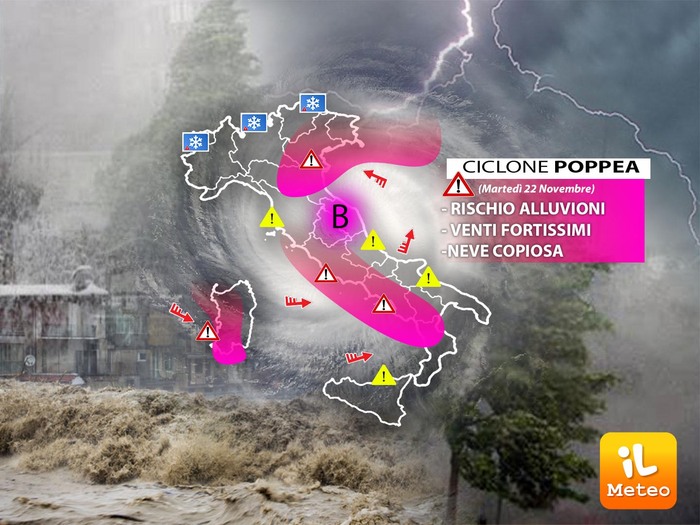
In detail:
Tuesday 22.
In the North: severe bad weather in the North-East, abundant snow in the Alps up to hilly altitudes;
storm winds.
Middle: widespread bad weather;
winds with intensity similar to a minimum category hurricane;
storm surges.
In the south: bad weather especially in Campania and then in Calabria with storm winds and storm surges.
Wednesday 23.
In the north: sun and cold.
In the middle: good weather, colder weather.
In the south: showers on the lower Tyrrhenian Sea.
Thursday 24.
In the north: sunny.
Middle: clear except for some night fog.
In the south: showers on the lower Tyrrhenian Sea.
Trend: another cyclonic vortex is approaching from Friday with first rains in the Centre, bad weather widespread in the Centre-South and Emilia Romagna on Saturday, floods on the Ionian sectors on Sunday.
Meanwhile, the effects of bad weather are being felt throughout the peninsula.
Mose defends Venice
The high tide in Venice reached 173 centimeters above sea level in the Adriatic at 9.40 today, but was successfully stopped by the Mose bulkheads, in operation from 2.00 today, on the three inlets.
Only 62 centimeters of tide was recorded in the lagoon at Punta della Dogana della Salute.
Without the Mose 82% of the historic city would have been flooded.
The forecasts gave a peak of
170 centimeters, the third by gravity after the tides of November 4, 1966 (194) and November 12, 2019 (187).
Whirlwind and floods in Sardinia
The storms and strong winds announced by the regional civil protection with the
red alert
, hit
the central-western sectors of Sardinia
.
The area most affected is the
Oristano area, with a whirlwind that hit the area
: Bosa, the village on the Temo, is under water, with the
river having overflowed its banks.
Its streets have turned into rivers and streams of water and mud.
The firefighters, coordinated by the provincial command of Oristano, have been working for hours throughout the province.
Critical situations are also reported in
Torre Grande and Cabras
, with the fall of trees and light poles.
Nearly
50 mm of rain fell in the southeast
of Sardinia, slightly less in Sulcis, Medio Campidano and in the Nuorese, gusts of wind exceeding 50 km/h: the island was violently hit by bad weather after a few weeks of spring weather
The red alert for the Oristano area, the entire Tirso area, part of the Nuorese area and the Montevecchio Pischinappiu area will in fact not cease before midnight between Tuesday and Wednesday.
The mistral wind promises to intensify, with
gusts of 100 km
per hour.
The mayors of some municipalities, starting from those of
Oristano and Bosa,
but also those of those centers in the
Nuoro area (
snow
is expected above 1,300 meters)
have ordered the closure of schools and city parks.
Orange alert instead in Sulcis, Logudoro and in the Sassari area.
Yellow for the rest of the island.
In these hours the incessant rain on
the metropolitan city of Cagliari is also worrying:
the municipality of Pirri is observed in a special way and warnings and rules of behavior in the event of flooding have already been issued since yesterday.
Dozens of interventions by the fire brigade teams, which in some cases - such as in the Oristano area - had to call back men and women who were retired or in reserve.
Sea storms on the Roman coast
It is one of the strongest storms in recent years that, since last night, has been lashing the entire coast of the Roman coast.
Waves over three meters
are putting a strain on beaches and bathing facilities from Ostia to the north coast of Rome.
Concern in particular on the coast of
southern Fregene
, which has long been struggling with serious erosion problems.
In some stretches of
Focene
the water has reached close to the inhabited centre, while flooding has been reported in the
Passo della Sentinella area, in Fiumara Grande, at the mouth of the Tiber.
The staff of the Divers Unit with 4 additional support teams and the amphibious vehicle are recovering
some people trapped in their homes.
The wind, with peaks of up to
90 kilometers per hour
, and all the fishing boats took shelter upstream of the canal port, due to the strong wave motion of the navigable canal.
In
Ostia
, in the seaplane base area, a small part of the breakwater barrier collapsed.
For this reason, flooding is currently being recorded, of limited scope and monitored by personnel from the fire brigade, Civil Protection and Carabinieri, who have intervened.
No one was injured.
Three homes were evacuated as a precaution.
The Lazio provinces of
Latina and Frosinone
were also affected by the bad weather .
In Rome, during the night, the firefighters carried out about 80 interventions, especially in the
Castelli Romani, Prenestina and Tiburtina
areas , where trees and branches were reported to be unsafe and flooding.
Orange alert in Campania
The whole day will be characterized by very strong winds, rains and thunderstorms, even of strong intensity.
In Salerno, Naples and in numerous municipalities in Campania
, schools will remain closed
, but also
the arches and city cemeteries
.
Castel dell'Ovo and Maschio Angioino will also be closed to the public.
In consideration of the particularly adverse weather conditions, characterized by strong winds and intense rainfall, citizens are advised to limit travel to those strictly necessary and to pay particular attention to the precautionary rules of behaviour.
Schools of all types and levels, state and non-state, closed in the Vesuvian area, in particular, in the municipalities of
San Giorgio a Cremano, Portici, Ercolano, Somma Vesuviana, Torre del Greco, San Sebastiano al Vesuvio, Massa di Somma, Pollena Trocchia and Sant'Anastasia
in the province of Naples.
Due to the heavy seas, the connections of the Campania capital with the islands of the Gulf were also interrupted.
In Avellino there are numerous
flooding of streets, garages and cellars
.
Traffic disruptions due to the flooding of the Ferriera bridge in the city center and in the connections with the peripheral districts, especially in Contrada Quattrograna.
Snow in Trentino
The first snow of the season has whitened the hills of Trentino and, in some cases, also reached the valley floor,
below 500 meters above sea level
, as happened in San Cristoforo di Pergine Valsugana.
The Province of Trento is monitoring the situation and at the moment there are no critical issues.
In case of need, the activation of the guard posts already identified along the provincial road network is envisaged, to allow the passage of only vehicles equipped with suitable winter equipment.
Snowfall also in Cortina d'Ampezzo, in the Veneto region.
Interrupted connections with the Island of Elba
Ferry connections to and from the island of Elba from Piombino (Livorno)
were temporarily suspended
due to weather conditions: strong winds and rough seas in the
Piombino
channel .
The last trip to
Portoferraio
, as reported by the Piombino harbor office, was the 9.30 Moby Micky one.
Also skipped the connection of the Liburna from Livorno to the island of Capraia, as confirmed by the Port Maritime Advisor, scheduled for 8.30, again due to the wind conditions that have been blowing since this morning with
gusts of 15/20 knots from the north-east .
Yesterday the regional civil protection issued a yellow code for wind and storm surges until 8pm on November 22nd.
Alert also in the Grosseto area.
Monitored the Sangro river in Abruzzo
The Civil Protection Functional Center of Abruzzo announces that "the reading of the hydrometric levels of the
Sangro
river
telemetry network signals that the alarm threshold has been exceeded and a gradual increase" and recommends "to implement the actions envisaged in the Municipal Plan of Emergency".
For the area in question, the Alto del Sangro basin, a bulletin of 'high criticality - red alert'
was issued yesterday .
Other areas at risk are the
upper basin of the Marsica and the Aterno basin,
for which the bulletin speaks of 'moderate criticality - orange alert', in the first case for widespread hydraulic risk and in the second for localized hydrogeological risk.
Yellow alert in the rest of the region.
As announced, the perturbation reached Abruzzo during the night, where it has been raining incessantly for hours.
If the inland areas are the most at risk, bad weather is also affecting the coast.
In Pescara, for example, intense rainfall has been underway since the night.
According to the surveys of the Aq Caput Frigoris association, the rainiest place is Villetta Barrea (L'Aquila), with a value of 133.6 mm of rain fallen;
on Mount Genzana the gusts of wind exceeded 120 kilometers per hour.
Electricity interruptions in Molise
Bad weather is raging throughout
Molise
.
The rain and strong winds create problems and inconveniences.
The Matese area was particularly affected, where there were also electricity outages.
Several floods.
Schools closed this morning in Bojano (Campobasso)
.
In several municipalities, trees and branches ended up on the roads.
The weather alert issued by the Civil Protection concerns the whole day today.
The Aeolian Islands unreachable due to bad weather
The strong wind from the south-south-west and the consequent increase in wave motion even today keep ships and
hydrofoils that connect the Aeolian islands moored in the port of Milazzo,
with inevitable inconvenience in schools, public offices and in the supply of commercial activities.
With today's stop to connections, the isolation of the smaller islands of the archipelago continues: Alicudi, Filicudi and the small village of Ginostra have not been reachable for over 60 hours.
Salina, Panarea and Stromboli for over 48. The only islands that were reached yesterday by a vehicle were Vulcano and Lipari, thanks to an extraordinary run by the ship Laurana which then returned directly to the Cape Town .