
The Feast of the Immaculate Conception starts well and will end with some clearing up, but bad weather will be widespread in the central part of the period: in practice, frequent rains on Friday and Saturday, snowfalls in the North and tense winds, especially in the Centre-South, will affect a good part of our Village.
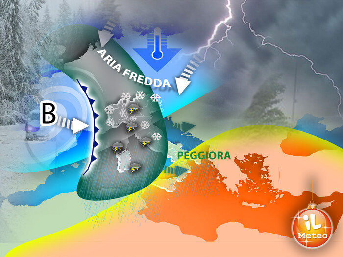
The synoptic picture indeed shows a Europe divided in two: beyond the Alps the cold has been stinging for some days, even in the plains;
on the other hand, in the Mediterranean basin the temperatures are still typically autumnal, if not even late summer, with 23°C between Sicily and Sardinia.
Andrea Garbinato, editorial manager of the website www.iLMeteo.it, indicates in this weather division of the continent the cause of the next bad weather: the polar air present in northern Europe will partly slide towards the south and will cause the deepening of an extensive area depression between Spain and France.
From this more unstable area various disturbed fronts will head towards Italy bringing a deterioration in the next few hours starting from the West, in particular from the Tyrrhenian regions and then towards Liguria.
In the next night the first significant phenomena will begin to arrive: snow is expected up to 300 meters above sea level between Western Liguria and Piedmont, locally up to the plains between Cuneese, Asti and Alessandria.
On the day when San Siro is venerated, Friday 9 December,
a few isolated fluttering flakes will circle around Milan, from Pavia to Bergamo, quickly moving from lower Piedmont to the central-eastern Alps, where the snow will instead fall abundantly up to 400-500 meters above sea level;
during the day, bad weather will hit the entire Tyrrhenian side with rains that are sometimes even intense between Tuscany and Lazio.
Saturday 10 December, due to the arrival of colder air towards Central Italy, a 999 hPa deep cyclone will form on the Tyrrhenian Sea which will activate twenty theses over a large part of Central-Southern Italy.
This cyclone could also cause new heavy rains in areas recently affected by violent hydrogeological instability: in particular, storms are not excluded in Campania as well, with the rains continuing to hit the entire Tyrrhenian area and the North-East.
In the central-eastern Alps we will have another load of fresh snow to the delight of skiers.
Finally, the last day of the Immaculate Conception, for those who can afford it as a holidaymaker, will see a partial improvement in the North-West and gradually also towards the Major Islands;
be careful however, thanks to the general drop in temperatures, from late evening local snowfalls could arrive as far as the coasts to the North-East, in particular with Bora winds and abundant flakes also in the hills of the Emiliano-Romagnolo and Marche Apennines.
In short, a decidedly unstable bridge: this year the month of December is bringing the rains that were absent a year ago.
More precipitation has already fallen in one week than the entire month of December 2021.
for those who can afford it on vacation, they will see a partial improvement in the North-West and gradually also towards the Major Islands;
be careful however, thanks to the general drop in temperatures, from late evening local snowfalls could arrive as far as the coasts to the North-East, in particular with Bora winds and abundant flakes also in the hills of the Emiliano-Romagnolo and Marche Apennines.
In short, a decidedly unstable bridge: this year the month of December is bringing the rains that were absent a year ago.
More precipitation has already fallen in one week than the entire month of December 2021.
from the late evening local snowfalls could arrive as far as the coasts to the North-East, in particular with Bora winds and abundant flakes also in the hills of the Emiliano-Romagnolo and Marche Apennines.
In short, a decidedly unstable bridge: this year the month of December is bringing the rains that were absent a year ago.
More precipitation has already fallen in one week than the entire month of December 2021.
IN DETAIL
Thursday 8
.
In the north: scattered rains from the evening, snow locally in the plains of lower Piedmont.
In the middle: rain towards the Tyrrhenian regions.
In the south: good weather and warm climate for the period.
Friday 9
.
In the north: bad weather with snow at low altitude.
In the middle: widespread rains.
In the south: rains arriving in Campania, sunny moments elsewhere.
Saturday 10
.
In the north: scattered rainfall, especially in the north-east, snowy at 1000 meters of altitude.
In the centre: widespread rains especially on the Tyrrhenian side, windy day.
In the south: worsening with thermal decrease, wind and rains.
Trend
.
Some rain on Sunday too, then a wave of frost in many regions