
The winter season, which has been somewhat subdued up to now, seems to have recovered from the torpor it had fallen into in the second part of the month of December: in fact, over the weekend the rains returned to the central-northern regions, with the snow peeped over the Alps, sometimes even copious.
During the week the meteorological scenario will continue to remain rather unstable, however before a new, fleeting comeback of the African anticyclone.
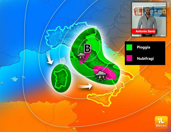
Antonio Sanò, director and founder of the website www.ilmeteo.it, communicates that today a vortex full of bad weather will move towards the southern regions: in the morning, last rains on the Northeast, while the bulk of the phenomena is expected on Lazio, Campania and Calabria.
According to the latest updates, up to 70 mm of rain is expected in 24 hours (70 liters per square metre).
At the same time, furious winds will blow over these sectors and throughout the middle and lower Adriatic, first from Ponente and Libeccio then, especially from the evening and during Tuesday, from Maestrale with gusts up to almost 100 km/h.
Tuesday 10 January some rain will still be possible on the southern peninsular regions and on Sicily;
elsewhere, however, the meteorological scenario will gradually stabilize, even if temperatures will drop during the night hours due to the strong winds from the northern quadrants.
In the middle of the week, a fleeting comeback of the African anticyclone is expected, which will conquer the lost space, spreading over the Mediterranean basin thus ensuring greater atmospheric stability with temperatures on the rise, especially in the maximum values.
But it won't last long.
IN DETAIL
Monday 9:
in the North, better in the Northwest, last rains in the Northeast.
At the Center: bad weather in Tuscany, Umbria and Lazio.
In the south: severe bad weather in Campania and Tyrrhenian Calabria, with storms.
Elsewhere, less intense rains.
Tuesday 10th
: in the North, sunny or partly cloudy.
In the centre: sun and strong Mistral winds.
In the South: the Mistral arrives, the last showers in Puglia and on the lower Tyrrhenian Sea.
Wednesday 11th
: in the North, clear or partly cloudy skies.
Increasing cloudiness from the evening.
In the middle: prevailing good weather.
in the South: alternating between clouds and sunny spells, in a dry context.
Trend:
new Atlantic perturbation from Thursday, extending from the North to the Center-South as the hours go by