
After a period characterized by the presence of high pressure and a decidedly mild climate, the weather is about to undergo a new change.
From the Atlantic Ocean, a perturbation connected to an active cyclonic vortex between the United Kingdom and Scandinavia will reach Italy, causing a general worsening of meteorological conditions.
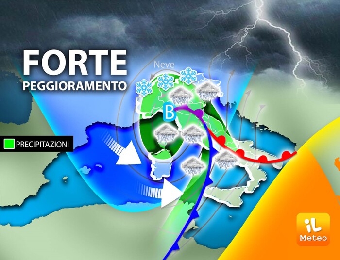
Antonio Sanò, founder of the website www.iLMeteo.it, says that the first signs of change will be noticed during the afternoon of Monday 13 when the cloud cover will increase sharply in the Northwest.
The trend, however, foresees sunshine everywhere from Thursday to Saturday, then a possible further deterioration.
In the evening the first rains will wet Liguria, at the same time the sky will also be covered over the rest of the North.
For the Northwest, the key phase of the bad weather will be the night and early hours of Tuesday morning, in fact widespread rains and local storms are expected in Liguria, especially in the east, rains in Lombardy where it will snow abundantly above about 1300 meters.
Even 20-40 cm of snow could fall in the Lombardy Alps in a few hours.
During Tuesday the bad weather will move towards the Northeast where it will persist until the evening, particularly affecting Friuli Venezia Giulia.
It will snow in the Dolomites above 1300 meters.
In the afternoon it will also get worse in Tuscany,
On Wednesday the perturbation will run fast towards the south, pushed by intense northern currents.
The Mistral will blow with gusts of up to 80 km/h both in the Centre-South and on the Alpine ridges.
The showers will quickly affect the mid-Adriatic in the morning and then more widely, but patchily, the southern peninsular, locally Messina.
In this context, temperatures will decrease.
The thermal decrease will be felt above all at night when the values will again be able to touch zero degrees on the flat areas of the North and also of the Center.
Finally, after the disturbed passage, the pressure will increase again giving another three days of sunshine prevailing on all regions, but from Sunday 19th the current data predict the arrival of a new deterioration.