Adeep cyclone has formed where the Azores Anticyclone normally lives: torrential rains have been in place for days over the Atlantic, towards the Canary Islands, Portugal, parts of Spain and Morocco. On the other hand, in Northern Europe we live an early summer with many bathers not used to this Mediterranean climate at high latitudes. An upside-down Europe that over the next few days will still see some storms on our country, even if we are facing a less turbulent period.
In Italy
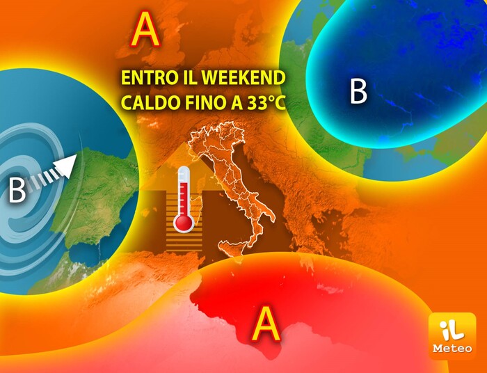
Despite the remoteness of the Azores Anticyclone and the timidity of the African Anticyclone, sunnier days are expected, compared to the Bridge of June 2 and at the beginning of this unstable and stormy week. An improvement, with a prevalence of sun and highs over 30 ° C over the weekend.
In particular, until Saturday we will find mostly sunny conditions in the morning and some thunderstorms close to the reliefs in the afternoon; Then on Sunday the weather could be a bit more variable with some more frequent downpours. An advance of the new week, 12-18 June, which is expected at the rainiest time.
These are projections for next week to be confirmed, but it seems that the 'Baric Marsh' may reappear, that is, the absence of a solid high pressure field over Italy: with this weather condition, which we have already experienced in recent weeks, new rains at times even intense would not be excluded.
IN DETAIL
Wednesday 7. In the north: thunderstorms in the Alps, in western Emilia and on Piedmont, sunny elsewhere. In the middle: afternoon instability on the reliefs. In the south: at times very unstable, especially in Calabria.
Thursday 8. In the north: thunderstorms in the Alps, rarer in the plains. In the middle: unstable in the Apennines, sunny elsewhere. In the south: some residual showers, but sunnier.
Friday 9. In the north: scattered thunderstorms in the Northwest and then on the Triveneto, rising temperatures. In the middle: more unstable on the Adriatic strip. In the south: mostly sunny.
Trend: rising temperatures and sunnier skies.


/cloudfront-eu-central-1.images.arcpublishing.com/prisa/S7ERVSCT4FUVX6R7TUVBDNTH5Y.jpg)