
Instant China
Written by: Xu Anan
2020-01-19 22:04
Last updated: 2020-01-19 23:16The China Seismological Network officially determined that a magnitude 6.4 earthquake occurred at 9:27 pm on January 19th in Jiashi County, Kashgar, Xinjiang, with a focal depth of 16 kilometers. The earthquake caused a strong sense of earthquakes, such as Atushi and Kashi, and Aksu also felt earthquakes.
Data from the U.S. Geological Survey (USGS) website indicate that the magnitude of the earthquake was 5.9 and was located 85 kilometers northeast of Arzak township.
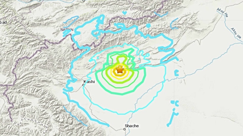
The picture shows the map released by the Weibo account of Xinqiang Earthquake Administration, showing the location of the earthquake.
The Beijing News reported that the villages within 10 kilometers of the quake include Baishidun, Tokule Village, Togzhek Creek Village, Ajirak Kream Village, Inmaili Village, and Ajilik Village , Aguirigrad, Toglakluk Village, Serik Toglak, Dangluk, the townships within 20 kilometers are Xikirkul Town, Wooli Toklak Town, Guleruk Township.
The epicenter was 970 kilometers from Urumqi, 56 kilometers from Jiashi County, 76 kilometers from Yuepuhu County, 90 kilometers from Atush City, and 110 kilometers from Maigaiti County.
Recently, there have been many earthquakes over magnitude 5.0 in the local area, including a magnitude 5.6 earthquake in Kuche City at 16:32 on January 16th, and a magnitude 5.4 earthquake in Jiashi County at 00:05 on January 18. According to Sun Shizhen, a researcher at the China Seismological Network Center, the earthquake zone is located in the South Tianshan earthquake zone. Since this year, there have been many earthquakes with a magnitude greater than 5.0, but the overall activity level has not exceeded the normal state of seismic activity in the area in history.
The US Geological Survey (USGS) recorded the magnitude of this earthquake at 5.9. (U.S. Geological Survey website)
Information from the U.S. Geological Survey website shows that the epicenter was close to a mountainous location. (U.S. Geological Survey website)
[Buffalo turned over] Taiwan Chiayi felt a 4.7 magnitude earthquake
[Zhuhai Earthquake] Experts from Guangdong: Earthquakes in Hong Kong and other places are normal
Tangshan magnitude 4.5 earthquake expert in Hebei: "normal ups and downs in aftershock area" of the 1976 earthquake
Two earthquakes hit Huai'an County, Zhangjiakou City, Hebei
earthquake


/cloudfront-eu-central-1.images.arcpublishing.com/prisa/GP2ZXWJRROQQUNBAGJPH3WIOVQ.jpg)