Social News
Written by: Chen Qianting
2020-04-05 13:57
Date of last update: 2020-04-05 13:57In a blog published today (5th) by the Secretary for Development Huang Weilun, the Surveying and Mapping Office of the Lands Department reviews the evolution of mapping technology over the past few decades. In the past, making maps required on-site measurement and calculation. Afterwards, we had to manually draw one stroke at a time. In order to be precise, we would also send staff overseas to learn to scan the landscape. It often takes more than a year to make a map.
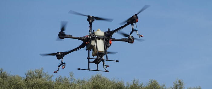
Benefiting from the advancement of technology, it has now changed to use laser scanning, vehicle and backpack mobile measurement systems, digital aerial cameras, drone shooting, etc. to collect data, and then use geographic information systems and mapping software to convert the data into maps. Increasing the accuracy of the map can also speed up the update speed of the map.
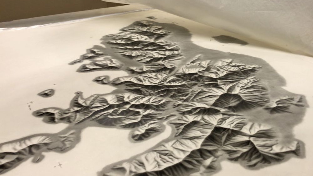
The blog of the Secretary for Development showed a hand-drawn map of the Hong Kong Island mountainous landscape in the 1980s. Zhang Weiming, a cartographer of the Surveying and Mapping Office of the Lands Department, revealed that colleagues needed to go overseas to learn how to scan landscapes with pencils and produce professional .
In the past, surveying and map making, including on-site measurement, calculation, and map drawing, required a lot of manpower and time. For example, the theodolite used for land surveying in the 1960s cannot directly measure the distance. It can only rely on measuring angles and using triangular geometry. Calculate the length indirectly. In addition, the map was drawn by the cartography team with one hand and one stroke at a time. Therefore, it took more than a year to complete the update to create a map.
He also showed various types of drawing tools, such as a stylus used to draw lines and look like metal pliers; a stylus used to insert a letter template; a rotary plotter used to draw out a balanced curve ("Tripod") )Wait.
The data is now collected by drones and then converted into maps by software
With the rapid development of technology, the department uses new technologies to improve traditional mapping operations, such as collecting data with laser scanning, mobile and backpack mobile measurement systems, digital aerial cameras, drone photography, etc., and then using geographic information systems and mapping software to convert the data For the map. The change in technology saves a lot of manpower and time, improves the accuracy of the map, and speeds up the update of the map for further planning and analysis.
The map products in the workshop have also developed from black and white maps in the 1960s to full-color production in the 1970s and computerized production in the mid-1990s. The way to read maps has also changed from paper products to electronic platforms such as personal computers, tablets, and mobile phones. In addition, the use of maps in daily life by citizens is no longer limited to hiking and outings. Instead, they are looking for meeting places and even planning trips.
Map reflects changes in coastline
The map also witnessed the rapid development and evolution of Hong Kong over the past half century. For example, the changes in the coastline, the density of buildings in the city, the increase and decrease of the road network and various infrastructures all marked the transformation of Hong Kong. Zhang Weiming showed two maps of the Shatian area printed in the 1970s. The first version was produced in 1974. At that time, Shatian had not been reclaimed and the Shing Mun River had not yet appeared. However, three years later, the updated map already had The racecourse, but the location of City One Shatin has not yet been reclaimed. From the update of the map, we can clearly see the unique landform changes and social development of Hong Kong.
[Wuhan Pneumonia] The government open data platform pushes the interactive map of epidemic situation at a glance
Netizen-made tear gas maps Index of all districts in Hong Kong One-click look at masks is useless. What is the solution?
Lands Department introduces "Street View Vehicle" for the first time, sets up laser scanner to produce 3D digital maps
Lands Department launches new version of geographic information map, citizens can instantly know weather and traffic status at the click of a button
Development Bureau plans to apply for 300 million yuan research and development data sharing platform to push three-dimensional maps available as soon as 2022
Map and Lands Department

/cloudfront-eu-central-1.images.arcpublishing.com/prisa/7BBFZMHM2JDPJH25TGODT4ZBT4.jpg)