
The most regular step possible, Christophe Courcaud begins his funny stroll along the beach of Cayeux-sur-Mer (Somme). Under the intrigued gaze of the few tourists present at the beginning of July, he set off to assault the longest plank path in Europe, holding in his hand a ball-shaped camera hoisted on a 1.5 meter pole. high. "There is a lot of wind, I must be careful to keep the device upright," he warns. It's both technical… and physical! "
Christophe Courcaud, 42, is not a hiker like the others but a modern-day cartographer. There are only a handful like him in the world, "an Italian, a South African specialist in national parks and safaris, and a Ukrainian who recently photographed the Chernobyl area", to browse the most remote places to immortalize them and make them available online on the Google Maps application and its Street View extension.
VIDEO. How Christophe maps tourist sites for Google Maps
Tahiti in Google Maps, that's him
Computer engineer, man is not a beginner in the field. It is thanks to him that Tahiti and a large part of the Polynesian islands have benefited, for only a few months, from a photographic presence on the application of the American giant. Because if Google has already photographed the vast majority of public roads in France with its Google Car, a car equipped with a camera on the roof, there are still large blank areas to cover.
This is the case in the Somme department, where Christophe Courcaud maps tourist sites only accessible on foot, by bicycle or even by canoe. On each outing, its six-lens camera films its environment in very high definition at 360 degrees. “The rhythm is 4 images per second when I'm on foot against an image every 3 to 5 meters when it's a car that takes care of it, explains the engineer. The graphic processing then makes it possible to extract images in which we can walk around virtually and see the surroundings as if we were there. "
Six objectives and a harness
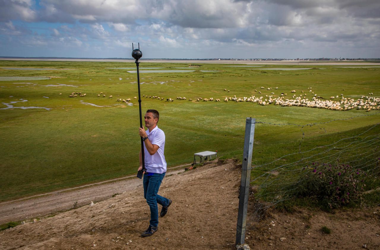
The day does not stop at the boards of Cayeux and its beach huts. Time to check the camera's battery level and change the memory card, Christophe Courcaud sets off on the coastal path. A hiking trail surrounded by nature which is not easy to discover if you do not pay attention to the tiny wooden stakes which painfully act as a guide.
The ride is this time longer, almost an hour and a half, and follows the bay between Cape Hornu and the Pointe du Hourdel, known for its seal colonies. The path borrows a levee from which we observe wild birds coming to drink in the water points spared by the tide and crosses between the salt meadows on which graze flocks of sheep. The horizon is superb, all in a shade of greens with, in the distance, the port of Le Crotoy and its boats whose masts are visible.
"The idea is to make tourists want to come and discover the department as a whole," explains Virginie Noppe, head of digital marketing for Somme Tourisme. This requires a presence on social networks, through the photos that we regularly publish with those that tourists post, but also by Street View by covering the most interesting places to visit but that are not yet covered by Google. "
Today a beach, tomorrow graves
The departmental tourist office, which finances the mapping operation, plans to digitize the 300 km of Somme cycle paths. "We plan to do the same with golf courses, for example, or even Australian, New Zealand or South African military cemeteries, which can thus be visited from their homes by the descendants of the soldiers who rest there," continues Virginie Noppe. "
Newsletter - The essentials of the news
Every morning, the news seen by Le ParisienI'm registering
Your email address is collected by Le Parisien to allow you to receive our news and commercial offers. Find out more
Very technical, Christophe Courcaud's mission requires a good dose of resourcefulness. For its campaigns on foot, the mast of its camera is inserted in a harness usually used by the amateurs of big game fishing which places their rods there. To immortalize the route taken by the tourist steam train which connects Saint-Valéry-sur-Somme and Le Crotoy, it is a small wooden board, bought the day before in a DIY store, and some plastic clamps which will do the trick to securely attach the equipment to the back of a car.
Filmed last Monday, the result, stunning so much that it looks like you are traveling installed on the roof of the train that goes, is already online and visible via the Google Maps application, on computer or smartphone.
How far will Street View go?
Launched in 2007, two years after Google Maps, which maps the living spaces of 98% of the world's population, Street View offers Internet users a 360-degree photographic vision of the outside world. Most of the roads and public roads in Europe (with the exception of Germany for reasons of privacy legislation) have been immortalized in this way by Google Cars. Nearly 16 million km of images, in 87 countries, can now be visited on Street View, but there are still many areas that cannot be driven over, and therefore not covered, such as natural areas in the mountains, beaches or private roads.
After taking the initiative to increase its coverage - notably by lending a backpack equipped with a camera to hiking enthusiasts -, Google is now handing over to the general public or to professionals like Christophe Courcaud to feed its database photographic. It is up to them to post, for free, their images, or to find sponsors to finance equipment and mapping campaigns.
To virtually visit a place, you must launch the Street View function in Google Maps from a computer or a smartphone. The covered areas can be identified by a blue line which highlights the map. You can also move the icon symbolized by a small yellow guy (bottom right of the application) on the map to be able to walk around in photos with a click of the mouse or a finger movement.