At least 100 dead, thousands injured and hundreds of thousands homeless. According to the authorities, some 2,750 tons of ammonium nitrate, stored "without precautionary measures" in the port of Beirut, are at the origin of the power of the explosions, the worst experienced by the Lebanese capital, despite its history. tormented.
The power of these explosions presented as accidental is such that they were recorded by the sensors of the American Institute of Geophysics (USGS) as an earthquake of magnitude 3.3. Their breath was felt as far as the island of Cyprus, more than 200 km away. The landscape, Wednesday, remains lunar: the containers look like twisted tin cans, the cars are charred, the ground littered with suitcases and papers from offices blown by the explosion.
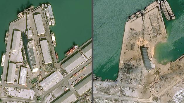
Satellite images of the port, shared by the Airbus company, allow us to take stock of the devastation that has hit the north of the city. You can move the slider from left to right, in the images below, to visualize the differences between the Port of Beirut before (left) and after (right) the dramatic explosions.
Other juxtapositions before and after the explosions:
Airbus
Airbus
Airbus
Airbus
Airbus
Airbus
Airbus