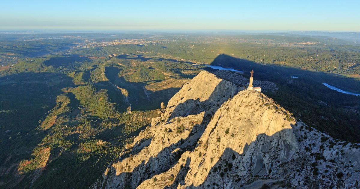
It has it all: The Pürzlgrat offers more than 1200 meters of altitude with phenomenal deep and far-reaching views of the Brunnensteinspitze, or Brunnsteinspitze.
You leave the busy Scharnitz quickly northeast and before you know it, the path winds its way up the mountain forest. Soon the path becomes steeper and narrower and you have to pay close attention to the markings. Eventually the forest thins out and more and more views become free: of the Karwendel neighbors, down into the valley of the young Isar and of the little toy houses of the village. When enjoying yourself, you should always make sure you have a secure footing, because the first, slightly exposed rock breaks require short climbs.
But the flatter upper part of the ridge can be reached quickly. Mountain pines dominate here, allowing you to enjoy the panorama that widens with every step unhindered: in the west the Wetterstein Mountains, in the south more and more glacier mountains of the Central Alps. You have to concentrate again, because the path leads past a ridge head on the right. Here, too, you have to lend a hand again and correctly assess the crumbly rock. The last stretch leads gently along a grass cushion full of flowers to the large summit cross. Now you can take a break and watch.
The Brunnensteinspitze is the corner post of the northern Karwendel range and you can study the other chains from here. Opposite is the massive Pleisenspitze, with which the middle and highest chain of the mountains begins. To the south, the Hohe Gleiersch sends a chain to the Praxmarerkar peaks with their gruesome north faces and on to the Bettelwurf.
The view of the southernmost chain extends from Seefeld over the Solsteine to Innsbruck's local mountains. The glaciated Central Alps protrude above these peaks. If you want to go back to the valley directly and as you are used to from the ascent, you return via the “Pürzlgrat”.
Incidentally, you can ponder the name as you like: The old term “borzen” means “protruding”, while “burzen” means “falling headlong” and suggests the comparison to “tumbling”. Whatever the case, it shouldn't deter the hiker from a safe descent. But a delightful variant leads on to the neighboring summit, the Rotwandlspitze, which is just eleven meters higher. From there the scenic, lonely, but also exhausting route over the "Feichtl" to the valley. This is the name of a huge gravel flank that descends southeast from the summit. The well-marked climbing tracks first cross soft grass mats, then a wide gray stone desert from which only individual plants protrude.
Especially on hot days you can hardly believe that “moist” should come from “damp”. However, a look at the grooves on the rocks reveals that when there is a lot of precipitation or snowmelt, some water has to flow over the slopes here. No matter which descent you choose; those who arrive at the bottom will want to take a break for their calves and thighs - and look back proudly on what they have achieved.
From Christian Rauch
BRUNNENSTEINSPITZE (2180 M)
ARRIVAL - A 95 Munich - Garmisch-Partenkirchen to the end of the motorway. Continue on the B 2 via GAP and Mittenwald to Scharnitz. There left towards Karwendeltäler to parking lot P2 (in the town center hardly any parking spaces). Due to the parking fee (6 euros), it is worth traveling by train; regular connection Munich-Innsbruck. From Scharnitz train station on the thoroughfare quickly to the tourist information.
TOUR - Walking time: 5.5 to 6 hours (slightly longer with the Feichtl route), height difference 1230 meters. Exhausting mountain tour. Surefootedness, a head for heights and physical condition required. Good knees and poles are particularly recommended for the “Feichtl” descent variant (very long scree section). Not recommended in wet or foggy conditions.
Course: From parking lot P2 back to the through road in the village. There right over the Isar bridge to the tourist information. Behind it right up into Inrainstraße. Now follow the green sign “Brunnstein” through houses uphill. Soon turn left (signpost "Brunnsteinspitze") and climb up on a steep path. Through steep forest, pines and gravel with simple, short climbing spots on the ridge and to the summit with a cross. Descent on the same route.
Descent variant: From the summit on the ridge to the nearby Rotwandlspitze (no cross) and from there right down to the small hut with the flagpole. Behind it, red dots begin, which lead to the right over grass mats (below the summit) into "Feichtl". Well marked over a very long gravel section down to mountain pines and forest. Finally on a forest path to a larger path. On this right, past the Birzl chapel. Shortly after a bank with a nature park sign to a junction (a small Snowshoe Trail sign on the left). Here right down and to a tarred road. This down into the place, keep right and down to the river. Before the bridge turn right to the train station or left over the bridge and right to parking lot P2. (The Feichtl route is only suitable for the descent).
MAP - Compass - Map 26, Karwendel Mountains .