
Videos show the damage caused by Laura 1:50
(CNN) –– Northeastern areas, the Great Lakes and the northern plains are facing damaging winds, massive hail and possible tornadoes on Thursday, according to the Storm Prediction Center (SPC, for its acronym in English).
New York City, Newark and Hartford in Connecticut are at Level 3 (out of 5) for severe risk.
Meanwhile, Philadelphia, Pittsburgh, Cleveland, Detroit, Sioux Falls, Milwaukee and Providence, Rhode Island, are under a level 2 risk.
The peak of these storms is expected to be from Thursday afternoon until late at night.
"Widely scattered to only scattered thunderstorms are forecast to develop toward the end of the afternoon over the northern high plains," SPC noted. In this area, conditions will be favorable for damaging winds and hail. In some cases, the hail could be larger than the size of golf balls or even billiard balls.
Additional severe storms from Hurricane Laura
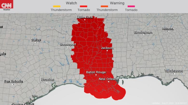
Hurricane Laura also poses a threat other than severe storms in the southeast. Damaging winds and flooding remain the primary concern, in addition to the threat of tornadoes.
A tornado watch was issued for Louisiana, Arkansas and Mississippi until 4 p.m. Central Standard Time. More counties may need to be added to the warning as the threat changes.
- READ: Minute by minute: Laura is now a tropical storm
Tornadoes are more common in tropical systems that make landfall in the Gulf of Mexico compared to storms in the Atlantic.
Laura produced two reports of tornadoes on Wednesday, but the number may be higher on Thursday. This is because the tornado threat is not limited to the shoreline or the day the system made landfall. More tornadoes can often occur the day after landfall, and can occur hundreds of kilometers inland.
A serious threat of several days
The threat does not end this Thursday. In fact, it will continue through the weekend, as storm systems move eastward.
"Strong to severe storms will be possible this Friday in a part of the upper Mississippi Valley, the Great Lakes and the Ohio Valley, with huge hail and damaging winds as the main threats," predicted SPC. "Other severe storms can occur in the Tennessee Valley region with some tornadoes and damaging winds as the main threats."
We're still talking about two separate systems: Laura will hit Tennessee, Mississippi, Alabama and Kentucky, while on Friday there will be another area of severe storms along a quasi-stationary front from the Midwest to the Great Lakes region.
By Saturday, the main threats will be along the Atlantic coast from the Carolinas to New Jersey, as Laura's remains accelerate toward the mid-Atlantic. Damaging winds will also be the biggest concern in this region, while the threat of tornadoes will be greatest in North Carolina and Virginia.
Hurricane Laura Bad weather Storm