
Imagine that you are lying on a beautiful day on a green hill watching the clouds go by.
You are probably thinking of cumulus clouds, those that look like soft cotton balls.
His appearance is most innocent.
However, they can become the most formidable cumulonimbus.
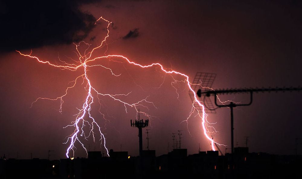
Lightning and thunder come from those monsters.
They are powerful, destructive, and intensely mysterious.
There are also signs that they are becoming more frequent.
So understanding how it works - and its effect on the human world, including how we build buildings and power lines - is more important than ever.
Many clouds form when hot air rises to great heights, where it cools and condenses into water droplets.
Storms occur when a cloud that is forming by this process grows and enlarges very quickly, absorbing more and more water vapor.
This is usually followed by rainfall and strong gusts of wind.
And, of course, the rays.
Although they are apparently a fairly rare phenomenon, it has occurred about 700 times - about 100 lightning strikes per second on Earth - somewhere on the planet in the time it took you to read this sentence.
Lightning and storms appear to be becoming more common, and there are signs that the trend will continue as a result of global warming.
In 2014, David Romps, a professor at the University of California at Berkeley (United States), developed an atmospheric model that predicted that lightning would increase by 12% for each degree of increase in the Earth's temperature.
Various signs indicate that this could be happening already.
In the Netherlands, several researchers have looked at the number of fires in the forests of Alaska and Canada caused by lightning and found that it has increased between 2% and 4% annually over the last 40 years.
Lightning is something we don't quite understand.
If, for example, we filmed the fall of one of them and projected it in super slow motion, we would see that it progressed by leaps and bounds.
According to Alejandro Luque, from the Andalusian Institute of Astrophysics in Granada, he pauses for a moment at intervals before continuing to advance.
We do not know why this occurs.
Luque comments that there are a few articles on the subject, but, in reality, no accepted theory.
The red specters
However, the researcher believes that he may have some of the keys to the problem thanks to his studies on an even more incredible but better known electrical phenomenon: red spectra.
Red spectra are huge jets of colored light that form 50 to 90 kilometers above the earth's surface, much higher than storms.
For years their existence was doubted, since they are difficult to see from the ground.
Luque has studied them primarily by looking at photographs taken by research aircraft.
Lightning and storms are becoming more common, and there are signs that the trend will continue as a result of global warming
Although less well known than lightning strikes, the physics of red spectra is easier to study because at such heights there is little air, so electrical discharges occur more slowly and at lower temperatures.
The rays cause temperatures higher than those of the Sun's surface. On the other hand, the discharge channels of the red spectra have "more or less the same temperature as the air that surrounds them," says the researcher.
The channels of the red spectra are made up of tiny filaments called "serpentines."
In the propagation of these, some of its points shine with more brilliance and persistence.
Luque explains that, in these electrical phenomena, the intense glow is due to the behavior of the electrons.
In some areas of the streamer, electrons adhere to air molecules, which increases the strength of the electric field producing a more intense light.
The jumps
This explanation does not admit discussion, says Luque, but what we do not know is whether an analogous process could explain - as the astrophysicist suspects - why the rays advance by leaps and bounds.
In the context of the latter, at lower altitudes there are more air molecules, and it is possible that the incorporation of electrons into them occurs in a somewhat different way, resulting in the "hopping" pattern.
Luque wants to verify it with his eLightning project.
Luque and his student Alejandro Malagón-Romero formulated the hypothesis in 2019. Now his team is working on the development of a computational model of rays to test whether the process they predict can explain discontinuous behavior.
Knowing why lightning strikes is not going to help us make it less dangerous, but Luque thinks that better understanding of the phenomenon may be useful in many other fields.
For example, discharges can form around power lines.
Consequently, they must be designed to minimize risk.
These discharges are also used in industry, for example in the treatment of waste gases and even in photocopying.
A better understanding of how they work could result in improved designs.
Lightning may seem like the most dangerous weapon in a thunderstorm arsenal, but lightning can also unleash extraordinarily strong winds.
Europe's weather is dominated by meteorological systems known as extratropical cyclones.
These are spiral currents of air that bring wind and rain with them when they pass through an area.
In a European city, they are produced on average between 70 and 90 a year, and scientists are well aware of how they work.
These storms can be strong, but they are not always.
Every time a building is built in Europe, architects have to make sure that it is able to withstand strong winds, and the model they use for this is based on extra-tropical cyclones.
The problem is that they do not take into account the winds considered infrequent, such as those that accompany thunderstorms.
Thunderstorms
To understand why this is important, you need to know the difference between cyclones and storms.
First, storms are more intense than cyclones.
While a cyclone can last three days, a storm can have passed in 20 minutes.
For this reason, instead of a moderate and continuous wind, we find ourselves with a series of very powerful gusts.
Second, more importantly, the force of the wind varies depending on the height.
Cyclones are stronger the higher the height.
Storms, on the other hand, usually create winds that start at about 100 meters high and blow down with more force as they descend.
“A normal wind blows parallel to the surface of the earth, while a storm blows downward.
It's totally different ”, explains Giovanni Solari, professor at the University of Genoa, in Italy.
Taking these considerations together, Solari continues, the result is that engineering is putting too much effort on taller buildings, primarily skyscrapers, and too little on shorter buildings and structures, such as shipyard cranes.
The top 200 meters of a 300-meter skyscraper probably won't get the push of a storm, but we designed it as if it would because our model assumes that the higher it is, the stronger the wind.
"We are building buildings that are too safe," he concludes.
On the other hand, a storm can capsize a crane, as it produces the strongest wind at ground level.
“Before, thunderstorms were thought to be rare.
... The reason was that we couldn't see them "
Solari's goal with his THUNDERR project is to correct this trend by developing a storm wind model that can be used to help design buildings.
In this way, the efficiency of the constructions would increase and their costs would be reduced.
The first step was to build on an artificial storm created in one of the most advanced wind tunnels in the world at the University of Ontario in Canada, and build a model of it.
According to Solari, that phase is now over, and his model was able to credibly reflect how artificial storms work.
But that was the easy part.
Currently, the engineer has started to model real storms, which vary greatly from each other.
In support, he and his team have built a network of 45 meteorological towers around the Mediterranean coast, designed to collect data on winds produced by storms.
"Before, thunderstorms were thought to be rare," Solari observes.
“The reason was that we couldn't see them.
The network has generated a database with 250 storm records.
Now the plan is to adjust the initial model so that it takes into account all those different storms and is truly representative. "
This article
was originally published in English in
Horizon, the EU research and innovation magazine.
The research for this article was funded by the EU.
Translation of NewsClips.
You can follow
Materia
on
,
,
or subscribe here for free to our
newsletter
.