
The
Vega
rocket
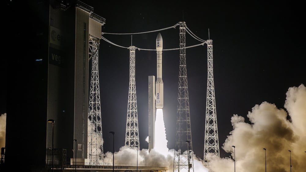
that carried the first Spanish Earth observation satellite SeoSat-Ingenio has deviated from its trajectory shortly after being launched this morning from the spaceport of Kurú, in French Guiana.
An anomaly occurred in the predicted trajectory just after the engine of the last stage of the rocket ignited and it was lost eight minutes after takeoff, according to technicians from the space center in the broadcast televised by the European Space Agency (ESA ).
En español
Mission to launch Spain's first Earth observation satellite fails after rocket veers off course
Before cutting off the television transmission, the technicians added that it was necessary to wait for more data in order to know what has happened.
The rocket, which in addition to the Ingenio also carried the French satellite Taranis, was launched at the scheduled time, at 2.52, Spanish peninsular time, and was scheduled, according to Arianespace plans, to separate the Spanish satellite 54 minutes after takeoff and the same with the French satellite 1.42 hours after launch.
Those responsible for the launch hope to be able to obtain more details of what happened at a press conference scheduled for this afternoon, and none of them have yet wanted to answer the questions of this newspaper.
Ingenio was to be placed in a heliosynchronous orbit, at an altitude of approximately 670 kilometers from where it will scan the Earth.
The
Vega
is a rocket developed by the Italian Space Agency (ASI) and ESA to put satellites into orbit, and its first launch was made on February 13, 2012 from Kuru.
We have liftoff for #SEOSATIngenio and #Taranis satellites: they are on their way towards space! # VV17
Follow the live transmission on https://t.co/4FgNeUjpZh pic.twitter.com/HGvBeBl1LN
- ESA EarthObservation (@ESA_EO) November 17, 2020
The deviation has meant the loss of the mission, which had planned to put the Spanish satellite Ingenio for Earth observation into orbit, considered one of the milestones of the Spanish aerospace industry, which has led its construction and which was to be commissioned over the next several years of both mission control and communications and the processing of all the data that he had to provide.
ESA has already begun to analyze the telemetry data to determine the cause of the failure, and officials of the Agency will appear this Tuesday at a press conference at the Kuru space complex (French Guiana) to report on what happened.
The first observation satellite
The artifact was one of the great prides of Spanish aerospace engineering.
It had planned to orbit at an altitude of 670 kilometers passing through the poles.
It was going to be able to take images of any point on the Earth's surface every three days and cover the entire Spanish territory eight times a year, and it would do so with a resolution never before achieved by any Spanish instrument thanks to its optical instrument equipped with two cameras with a system of mirrors that concentrate the light to compose an image of 60 kilometers on a side and in which each pixel represents 2.5 meters, which would allow you to see details on the ground the size of a car approximately.
The images of Ingenio were to be used for cartography, agriculture, natural resource management (level of reservoirs), emergencies and security, for example, warning of fires, indicating the level of nutrients of a crop to know how much fertilizer to use or detecting illegal constructions .
The Spanish satellite would also have been able to access and image any point on the Earth's surface every three days, making it especially useful for mapping unpredictable natural disasters, such as floods, forest fires and earthquakes, as well as helping to understand one of humanity's greatest challenges: climate change, as the Ministry of Science explained a few days ago in a press release.
The Minister of Science, Pedro Duque, presented a detailed report last week to the Council of Ministers on all the services that the satellite could provide to public administrations.
The project has had a total cost of around 200 million euros and has been led by the Ministry of Science and Innovation through the Center for Industrial Technological Development (CDTI).
75% of all Ingenio's technology is Spanish, which makes it the satellite with the most national components that has been developed to date.
Its promoters hoped that having carried out this mission successfully would allow Spain to compete to manufacture new artifacts of this type, such as those of the Copernicus program of the European Union and the ESA.
The instrument would also have had military uses, especially as a complement to Paz, a radar satellite of the Ministry of Defense that was launched in 2018.
You can follow
MATERIA
on
,
,
or subscribe here to our
newsletter
.