
MORE INFORMATION
In the book '101 wonders of the world' and on lonelyplanet.es
Infinite jungles of an intense green, glaciers from which blocks of ice the size of buildings are detached, temples of ancient civilizations that rise towards the sky semi-hidden among the dense jungle ... in South America there are wonders of unquestionable beauty that should be seen at least once in life.
Tuistas enjoy a sunbath in hammocks at a 'resort' on the banks of the Amazon River, in Ecuador.
Sébastien Lecocq alamy
1. The largest green space on the planet: the Amazon rainforest
Spread across nine countries and covering approximately 40% of the continent,
the Amazon rainforest is the largest green space in the world
.
With more than 7 million square kilometers, the Amazon basin is also home to the largest collection of terrestrial fauna and flora, an astonishing biodiversity that makes it difficult to understand and explore.
Despite the fact that tourism has reached the most remote places on the planet, the Amazon is still an optimal place to live a great adventure, although increasingly with more facilities, which takes away some of the romanticism.
You can walk through the dense forest, visit indigenous villages, fly over huge green expanses and winding waterways, navigate slowly between riverside villages or relax in a lodge in the middle of the jungle after a day of wildlife observation.
The nine countries that share the Amazon have different access points to explore this great green lung:
Leticia (Colombia)
,
Iquitos and Puerto Maldonado (Peru)
, and
Manaus (Brazil)
, are the main ones, but we must not forget that they also share this immense territory with Venezuela, Bolivia, Ecuador, Guyana, Suriname and French Guiana.
Wherever you enter, there is something in common in every Amazonian experience: when you enter,
you completely disconnect from the modern world
.
Rivers become roads;
monkeys, traveling companions;
and the cacophony of birdsong is the alarm clock in the morning.
The bugs are part of the landscape, the weather is erratic and the air becomes dense and envelops the visitor completely.
But this is a good part of the adventure of entering the Amazon.
Three national parks on the Andean border compete to be the most biodiverse protected area in
the world.
No one knows for sure which of them holds that title, but the reality is that here nature has no borders.
Whether you arrive from the Madidi National Park in Bolivia, or from the Guiana Amazon Park in French Guiana, or from one of the innumerable intermediate entrances, the experience in the largest jungle in the world leaves no one indifferent.
It is a journey that marks a lifetime
.
A camper van crosses the Salar de Uyuni, in Bolivia.
Westend61 getty images
2. An immense void of salt: the Salar de Uyuni (Bolivia)
The highest salt mine in the world (at 3,653 meters of altitude), and also the largest (12,106 square kilometers), is in the Andean antiplano, in the extreme southwest of Bolivia.
At first glance,
the Salar de Uyuni is a desolate place
, with a cold so intense that it chills the bones, but the experience is unforgettable.
In this landscape that seems from another world, you can only go by jeep.
A three or four-day excursion allows you to approach it in its entirety and realize its
nakedness and its crystalline perfection
, which leave those who come here astonished, with a sense of permanent awe.
Start your tour first thing in the morning, between rock gardens, geyser fields and hot springs.
The
train cemetery
, the
Cochani salt flats
and the
salt hotel
, and the spectacular
island of Incahuasi
(better known as Fish Island), in the heart of this white desert, are some of its essential visits.
Walking at that altitude, with little oxygen, is a strange sensation: the breathing accelerates and the heart beats with force.
Uyuni offers a disturbing and suggestive image
: when the surface is dry, the salt flat is an extension of pure white, the largest imaginable void: only the blue sky, the white ground and the visitor.
When there is a little water, the surface perfectly reflects the clouds and blue sky of the highlands, and the horizon disappears.
Driving through the salt flat at that moment gives the impression of flying through the clouds.
Few places in the world are as disorienting as this blinding white surface, where
70% of the world's lithium reserves
are stored
.
When you lean your head to rest on a bed made of salt, inside a hotel built entirely with salt, you can't help but feel a deep connection to the thirsty land.
Caño Cristales, in Colombia, is considered by many to be the most beautiful river in the world.
jorge ivan vasquez cuartas getty images
3. A river of five colors: Caño Cristales (Colombia)
Between the Andes and the Amazon are the tropical plains of central Colombia, with its millions of head of cattle, its seasonally flooded grasslands ... and the most striking river in the world: Caño Cristales.
The so-called river of the five colors (for its yellow, blue, green, red and black tones) or liquid rainbow, in the Sierra de la Macarena National Natural Park, in Los Llanos, is one of the most fascinating natural wonders of Colombia and from all over South America.
Caño Cristales is not really a riverbed, but a set of rivers, streams and waterfalls in the heart of this park, which owes its magic and its chromaticism to a unique biological phenomenon that lasts a couple of months (between July and November): a endemic algal eruption produces a brilliant red underwater mantle.
The crystal clear waters of the river are transformed into a burgundy-colored stream, which contrasts with the magical lunar landscape of ancient water-eroded rocks from its riverbed and the surrounding savanna.
To visit Caño Cristales you
have to sweat a lot walking through canyons
that open between the rock, although with unforgettable pleasant moments, such as receiving a shoulder massage under a waterfall.
You can also do
a photographic safari by boat on the Guayabero River
or breathe the air of the savannah walking to viewpoints high in the mountains.
This part of Colombia has just opened up
after years under the control of the
FARC
(Revolutionary Armed Forces of Colombia), so tourism is still a small-scale community business.
But it is not a secret destination: Colombians come during weekends and long weekends and the daily visitor quota (180) is not always respected.
It cannot be visited independently, but it is mandatory to enter the national park with an official local guide.
If possible, it is advisable to visit it during the week.
A platform enabled to contemplate the Iguazú Falls, on the border between Argentina and Brazil.
WIN-Initiative getty images
4. The thunderous emptiness of Iguazú (Brazil and Argentina)
Iguazú is not a single waterfall but more than
275 curtains of water
that hang down in the middle of the jungle, on the southern borders of Brazil and northern Argentina, forming
the largest system of waterfalls in the world
.
The impression when you arrive before these immense falls is spectacular: looking at them from the safety of a walkway, we are surrounded by huge jets of water that rush over green mountains, into an abyss from which only steam rises.
On the Brazilian side, the falls are possibly more photogenic than on the Argentine side
, where you have to approach the deafening Devil's throat, surely the most amazing moment of the visit.
The impression of staring into space is incredible: flocks of swifts drift in and out of waterfalls while toucans flaunt their massive peaks on the adjacent mountains.
And a cloud of mist rises over the walkway visitors walk under the thunderous sound of falling water.
It is a very special place: thousands of years before they were
discovered
by Europeans, the falls were a
sacred burial site
for the
Tupi-Guarani communities
.
The Spanish Álvaro Núñez came across them in 1541, and baptized them as
Saltos de Santa María
, but since the name did not catch on, its original place name remained: Iguazú (Great Waters).
In 1986 they were declared
a world heritage site by Unesco
, and in 2011 they were chosen as one of the new seven wonders of nature.
The Iguazu Falls, with 2.7 kilometers of water curtains, are three times wider than their North American cousins of Niagara, and have the added exoticism of being surrounded by a jungle full of
jaguars, monkeys and alligators
.
If you try to follow a piece of river through the falls, the visitor will also be amazed at the power that water has to shape planet Earth.
Sea lions on a beach in the Galapagos Islands (Ecuador).
PRASIT CHANSAREEKORN getty images
5. In the footsteps of Darwin in the Galapagos Islands (Ecuador)
Traveling to the Galapagos is like traveling to a
prehistoric world
populated by a strange fauna that is not scared of humans.
Far from it all, they are the same islands that served to
inspire
Charles Darwin
(1809-1882) to inspire his scientific theories when he traveled here in 1835 and still today change the world view of many travelers.
Following in the footsteps of the English naturalist and the strange animals that inspired his
theory of evolution
is one of the essential adventures for all nature lovers.
These 21 volcanic islands on both sides of the Equator and 1,000 kilometers off the coast of South America, conserve one of the highest levels of endemism on the planet: about
97% of their reptiles and land mammals cannot be found anywhere. another place in the world.
They are an extraordinary place, an alternate universe with a strange utopian colony organized by
sea lions
and governed by the principles of mutual cooperation.
The Galapagos are far from being your typical paradise islands.
They do not have lush tropical landscapes, it is not full of idyllic beaches.
They are islands of
volcanic origin
(it is the second archipelago with the highest volcanic activity after Hawaii) in which in many areas there is not even vegetation.
The landscapes are inhospitable
, covered in lava and with strange
red sand beaches
or
barren volcanic craters
.
Its originality and value lie in the possibility of observing a strange fauna: lethargic
marine iguanas, old giant tortoises and blue-footed boobies
.
For the few and privileged visitors (there is a fixed quota of tourists per year), what is most striking and extraordinary is that the animals instead of fleeing in terror, remain calm and do not seem to be bothered by the cameras or by their owners.
The most important island in the archipelago is
Santa Cruz
, with the largest population on the island,
Puerto Ayora
, where much of the tourist infrastructure is located.
The islands have been a national park since 1959 and organized tourism is highly regulated, with a limited number of visitors per year to preserve their delicate biological balance.
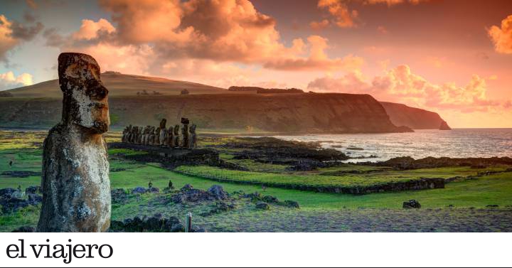
6. The Watchers of the Pacific: Moáis of Easter Island (Chile)
Like castaways guarding the horizon in the middle of the Pacific Ocean,
the moai of Easter Island
remain an enigma.
Striking and surprising, these immense stone statues are the best known image of this Chilean island, almost lost, some 4,000 kilometers from the American continent and another 4,000 from Tahiti, towards the interior of the South Pacific.
There are 288 statues and they are scattered throughout the island, placed on stone platforms, like colossal puppets in a supernatural setting.
The question of how these giants moved from the place where they were carved to the place they now occupy remains unanswered after many studies and analyzes.
It is believed, yes, that they represent the ancestors of the clans.
But what led an isolated civilization to carve such images and how did they carry them from the quarries in the interior to the ceremonial platforms (
ahu)
on the coast?
And there is still more: why were they demolished all at the beginning of the 19th century?
All these mysteries and the remoteness and isolation of the territory of Easter Island (Rapa Nui, for its inhabitants), attract thousands of curious travelers every year, who return home with more questions than answers.
And it is that, at 3,700 kilometers from the mainland, Easter Island is one of the most isolated places on Earth, so much so that looking at the horizon you can see how the earth curves.
Although it probably
shares a Polynesian past with Tahiti and Hawaii
, it has little to do with a tropical paradise: it is a barren, volcanic land, with a bit of sand, lots of sun and waves, but above all, it is an archaeological museum to the The open air and its visitors come to look into the eyes of the 10 meter high moai and imagine the stories they could tell.
Now, the island is also an
ecotourism destination
, offering
fabulous
snorkelling
and
scuba diving
, as well as other options to enjoy the island, such as hiking the rugged and beautiful north coast, taking
walks to horseback riding
down the slopes of the extinct
Maunga volcano
or simply taking a nap under the palm trees on
Anakena beach
.
And of course, watch the sun rise behind the row of mysterious
Ahu Tongariki
statues
.
The island has been a Chilean territory since 1888 and all its inhabitants speak Spanish, a great incentive for the Castilian-speaking traveler.
A tourist descends some stone steps in the citadel of Machu Picchu.
Anna Gorin getty images
7. The mysterious lost city of Machu Picchu (Peru)
The fantastic Inca citadel of
Machu Picchu
, lost from the world until its rediscovery in the early 20th century, is a ruin upon ruins.
The complex is astonishing for its appearance and, above all, for its location, on emerald-colored terraces surrounded by Andean peaks and ridges, forming an incredible spectacle.
The citadel itself is an engineering marvel that has withstood six centuries of earthquakes, invasions, and inclement weather.
The vast stone citadel often appears to visitors shrouded in mist and surrounded by vegetation and steep cliffs.
Its image is part of the universal imagination, like
the pyramids of Egypt
or the
Mona Lisa
, but it is impossible to describe the emotion that one has when arriving at the place.
It is easy to understand why the Spanish conquerors never knew of its existence, which remained almost in oblivion until 1911, when the American
Hiram Bingham
discovered it.
Part of the charm of this citadel on top of the mountain lies in reaching it through the route used by its ancient inhabitants.
The Inca Trail
runs through cloud forests, crosses three high Andean passes, and passes through various Inca ruins and Quechua communities of potato growers and llama herders.
Machu Picchu is a complex of ceremonial squares and temples surrounded by mist and covered with vegetation.
There are terraces (some of them are used again for crops) that go down steep cliffs overlooking a
U-shaped
curve of
the Urubamba River
. And tourists fight for the opportunity to climb the
Wayna Picchu
, the high mountain that is rise behind the ruins, to contemplate the amazing city in view of the condor.
Despite the many tourists who access the place,
Machu Picchu keeps all its mystery intact
.
We may never know what the Incas did here, but it will always be possible to let your imagination run wild as you contemplate this masterpiece of an ancient civilization.
The Marble Chapels, on the turquoise waters of Lake General Carrera, in Chilean Patagonia.
Gravel PV alamy
8. Sculpted caverns of the Marble Chapels (Chile)
In the north of Patagonia there are some of the Chilean natural wonders, such as the
San Rafael glacier
, located in the so-called Northern Ice Fields, and also one of the most unusual geological formations in the country:
the Capillas de Mármol
, a Chilean national monument. .
It is a series of surprising mineral formations located on the shores of
Lake General Carrera
, in the Aysén region, the second largest lake in South America.
The chapel is actually a cave next to a turquoise lake, formed by the action of the waves on calcium carbonate for thousands of years.
It is in a privileged place, on the rugged shore of the lake, where the icy waters coming from the glaciers are tinged with a deceptive Caribbean hue.
The formations are known as
Marble Cathedral, Marble Chapel, and Marble Caverns.
Less well known than many other wonders of the continent, the chapel is a spectacular place, of incredible beauty, which can be appreciated even more if one approaches in a kayak route first thing in the morning, navigating between the columns that form arches that seem welcome us.
As the sun enters the caves, the water forms a mirror in which the striations of the stone that rise to the ceiling are reflected.
A difficult place to imagine if you don't experience it.
To get to the lake basin, you have to travel for hours along the rugged
Austral highway
, the only way to connect the isolated communities of northern Patagonia with the rest of the country.
It is an incredible journey that reaches
Puerto Río Tranquilo
, a town of wooden houses on the shores of the lake, the closest starting point to go to the caves, but also to go to other places such as the impressive San Rafael glacier, al It is reached through
the Exploradores Valley
, a beautiful but rugged road, full of glaciers.
Do not miss the
Glaciar Exploradores
viewpoint
.
El Salto del Ángel, the main tourist attraction in Venezuela.
FabioFilzi getty images
9. An almost heavenly fall: Angel Falls (Venezuela)
It is the highest waterfall in the world and also the
main tourist attraction in Venezuela
.
The jet falls from the top of Auyante pui, one of the largest tepuis (high and flat plateaus) in the country, from 979 meters.
The jump is 16 times greater than Niagara Falls, with an uninterrupted drop of 807 meters.
To get here, you can fly over the surreal landscape of tepuis to the Canaima National Park, in Venezuela, and land next to the pink waterfalls of
the Canaima lagoon
, and continue on a five-hour canoe journey through the dense jungle to the
Laime viewpoint
, overlooking the Angel Falls.
It is possible to swim while contemplating its fall and then spend the night in a hammock camp to the lullaby of the jungle.
There is no road that connects with the rest of the world.
When your eyes finally land on the waterfalls, what you see is a river whose waters touch the sky and that have carved a fine path through Jurassic nature.
At twice the height of the New York Empire State Building, it dominates the landscape and is so spectacular that it is impossible to stop admiring it.
The fact that Angel Falls falls from a heart-shaped tepui onto a place known as
Devil's Canyon
only adds to the intrigue.
His name does not refer, as might be expected, to any heavenly creature, but to the American pilot
Jimmie Angel
, who landed his four-seater airplane at the top of the Auyantepui in 1937, while he was searching for gold.
The Pemones of the area called it
Parakupá Vené
, that is, “waterfall from the highest place”.
Around the Angel Falls, the valleys and virgin forests of the Canaima National Park invite you to continue the adventure.
The waterfall is in the middle of unspoiled nature.
The town of Canaima, some 50 kilometers to the northwest, is its main access point.
The amount of water that falls from the waterfall depends on the season.
In the dry months - from January to May - it can be quite scarce, with only a fine thread that turns into mist before reaching the bottom.
In the dry months it is not accessible by boat.
On the other hand, during the rainy season, especially in the humid months of August and September, the waterfall is a spectacular waterfall of water that plummets, although rain and clouds can obscure the views.
The Temple of the Great Jaguar or Temple I, in the Mayan city of Tikal (Guatemala).
Michel Gounot Getty Images
10. Mayan temples in the middle of the jungle: Tikal (Guatemala)
The Mayan temples of Tikal
stand, extraordinarily restored, in a corner of
the Petén jungle
,
in northern Guatemala.
They amaze both for their size and for their architectural prowess.
With its towering temples at almost impossible angles, and its imposing squares, the complex represents the cultural and artistic strength achieved by the Mayan civilization, which occupied the city for 1,600 years.
Of the many squares that make up the archaeological complex, trees and lianas have been removed, and the temples have been discovered and partially restored, but when touring these buildings under a jungle roof, one has the pleasure of discovering the original wide roads that joined the different temples, as if we were the first explorers to do so.
Tikal was one of the most powerful kingdoms of the Mayan civilization, reaching its peak between the years 200 and 900. Built over nearly eight centuries, Tikal is a succession of hundreds of temples, pyramids and stelae.
There is no way to see it all in one day, but the highlights:
the Pyramid of the Lost World
,
the Square of the Seven Temples
,
Temple IV,
the highest,
Temple VI and VI
, the
Great Plaza
or the so-called
Acropolis of the North
.
Strolling among these relics of the past, some of which rise more than 40 meters above the Guatemalan jungle, allows us to imagine what the city could be like when kings and nobles lived there.
If you walk in silence, we will only hear its current residents (
agoutis
,
coatis
and
spider monkeys
) under the trees.
After climbing a steep wooden staircase, from the high Temple IV, on the western edge of the enclosure, there is
a fabulous view
.
This temple is the second tallest pre-Columbian building in the western hemisphere (44 meters).
Lake Pehoe and, in the background, the Cuernos Mountains, in the Chilean national park of Torres del Paine.
DPK-Photo alamy
11. The verticality of Torres del Paine (Chile)
The granite pillars that form
Torres del Paine
rise almost vertically to more than 2,000 meters above the Patagonian steppe in southern Chile.
This landscape is considered
the best national park in South America
.
Visitors flock mainly attracted by the irresistible image of its granite formations, but once there, they discover that there are many other interesting and less frequented spots: turquoise lakes, paths through emerald forests, rivers that are crossed by rickety bridges and a huge glacier of intense blue color.
In 1978 it was declared
a Natural Reserve of the Biosphere by UNESCO
.
It is home to flocks of ñandús, condors of the Andes, flamingos and many other species of birds.
It is not easy to walk through this reserve, in which they say that the four seasons can happen in the same day.
However, touring
the mythical W circuit
(between four or five days of walking) is a rite of passage for adventurers.
Others prefer the so-called
Circuito del Paine
(seven to nine days), more solitary, but with incomparable views and a greater challenge.
A trekking route through the Perito Moreno glacier, in the Los Glaciares national park, in the Argentine province of Santa Cruz.
David Silverman Getty Images
12. The collapsing glacier: Perito Moreno (Argentina)
The
Perito Moreno
, with its 30 kilometers long, five wide and 60 high, is the most spectacular glacier of the ice fields that make up the
Los Glaciares National Park,
in Argentine Patagonia, southwest of the province of Santa Cruz , on the border with Chile.
In addition, being relatively easy to access, it is an essential stop on any trip to southern Argentina.
It is exceptional for its rate of movement of up to two meters per day, a slow but unchanging advance that overwhelms those who approach this wall of ice to see icebergs, sometimes the size of entire buildings, fall off. thunderous shape over
Lake Argentino
, the southernmost of the continental territory.
A network of steel walkways and platforms allows you to get very close to this unusual spectacle and wait for the next mass of ice to break off and slowly submerge in the water, causing an unforgettable swell.
Aerial view of the tropical island of Cayo de Agua, in the Venezuelan archipelago of Los Roques.
gustavo adolfo rojas alamy
13. An almost virgin island paradise: Los Roques (Venezuela)
In Los Roques, in the Caribbean Sea, the main activity is to go from island to island: there are more than
300 sandy islets
that make up this Venezuelan archipelago, surrounded by aquamarine waters, about 160 kilometers north of Caracas.
It is
the third longest reef in the world
, with mythical diving spots for divers, such as
Boca de Cote, Crasqui and Noronquises
, where many go to swim among sea turtles.
Los Roques are islands for lovers of
deserted beaches
,
snorkeling
and
diving
, almost all of them uninhabited and only accessible on day trips from
Gran Roque
, the main island and where the only population center is.
The entire archipelago, and the waters that surround it (a total of 2,211 square kilometers), was declared a national park in 1972 and has the largest coral reef in the Caribbean.
And although wandering the islands is the main attraction, Gran Roque also has a wonderful beach, occupied by fishing boats and other recreational boats.
From there, deep-sea divers set out to dive in search of its marine life, and fishermen stock almost every restaurant with fresh fish and seafood.
To contemplate sunsets you have to go up to the Dutch lighthouse that culminates on the hill in Gran Roque.
The infinite dunes of the Brazilian national park of Lençois Maranhenses.
DEA / S. RENIS getty images
14. The magical dune landscape of the Lençois Maranhenses
(
Brazil)
Like a
mirage of unfolded sheets
: this is the image of
the immense sand dunes of the Lençois Maranhenses National Park
, in Maranhao, an area 70 kilometers long by 25 wide (
about 1,500 square kilometers, three times the size of the city of Madrid
) that from the air can look like a surface of
lençois
(sheets) stretched out in the sun until it disappears into the horizon.
Halfway between Sao Luis and the border with Piauí, the Lençois is a spectacular and unique place, especially from
May to September
, when the rain that has filtered through the sand forms
thousands of ponds and crystalline lakes between the dunes.
The park is home to beaches, mangroves, lagoons, and some interesting animals, especially turtles and migratory birds.
It is recommended to visit it by jeep, by boat (going down the Preguiças river, in the jungle) or on a three or four-day hiking excursion through the Lençois, sleeping in hammocks or fishermen's huts in the few, tiny and poor villages that there are by the way.
The most recognizable remote towns are
Atins,
where the Preguiças empties into the ocean, and
Santo Amaro
, at the western end of the park, with dunes that reach their limits and sandy river beaches where we can bathe.
A diver goes through a tunnel deep in the Great Blue Hole in Belize.
ALAMY
15. The eye that watches over the Caribbean: the Great Blue Hole (Belize)
The image of this perfect blue circle, which can be seen from the sky, is one of those photographs seen a thousand times on the Internet.
With its different bluish hues, it looks like a watchful eye in the middle of the sea.
The walls of the Great Blue Hole reach more than 120 meters into the depths of the ocean and, although it is half filled with sediment and natural debris, its depth still maintains that perfect, circular shape.
Inside, divers are encouraged to descend to the mysterious depths of this sinkhole to contemplate the stalactites and stalagmites that hang from the walls, accompanied by a school of reef sharks, hammerhead fish and many other invertebrates and sponges.
The first dive was made in the 1970s by
French explorer Jacques Cousteau
, who made it one of the best places in the world for scuba diving.
Since then, the image of the Great Blue Hole, a pupil of an intense dark blue that contrasts with the different shades of the turquoise waters and the shadows of the surrounding reef, has become very popular, although not many would know how to locate it on a map.
The only way to get to this unexpected wonder of nature is by private boat or dive boat from
Caulker Cay
or
Ambergris Cay
.
Diving in the Great Blue Hole is often combined with others in the
Lighthouse Reef
, which are much better for experienced divers.
Find inspiration for your next trips on our Facebook and Twitter and Instagram or subscribe here to the El Viajero Newsletter.