
Instant sports
Written by: HK Discovery
2020-12-11 12:33
Last update date: 2020-12-11 12:40
Yuen Tsuen Old Road is a section of mountain trail connecting Yuen Long and Tsuen Wan. It was also an important route for residents of the New Territories to travel between the two places.
The ancient road starts from Tsuen Wan down to Huashan, passing through Shilong Gong, Tian Fu Tsai, Yongji Bridge, and ends at Tai Tong Shan Road, Yuen Long. Yuan Tsuen Old Road Country Trail Marked Distance Columns C6101 to C6126.
Length: 9 kilometers Time: 6 hours
In the first section, it was difficult to climb up the stairs from Lower Flower Hill, but in the following section, you can clearly see the magnificent scenery of West Kowloon, Tsing Yi, Ting Kau Bridge, Tsing Ma Bridge and Lantau Island. The previous hard work is worthwhile.
Before hiking, learn about hiking etiquette:
+10
+10
+10
When walking through the path of Shilong Arch, you might as well pay more attention to the stones around you. Among them is a famous Hericium, which looks like the side of a smiling monkey king from a distance.
After passing Tian Fu Tsai to Jiqing Bridge near Dalanyong Reservoir, there is a lawn for resting.
Then you can visit the northern end of Tai Lam Chung Reservoir, and follow the signs to continue going up until you reach the junction with Tai Tong Nature Education Trail.
Walk in the direction of Nankeng Pai, and you will see some geographical sites on the way.
Then we arrived at the end of the country trail-Yuen Long Tai Tong BBQ Ground.
In the middle of Yuanquan Ancient Road, there is a bifurcation near your location "JK973 783" to the direction of Qingkuaitang Village. Follow this road for about 45 minutes to reach Sham Tseng.
Click on the picture below to see the characteristic scenery of Yuan Tsuen Ancient Road Country Trail! 👇👇👇
+8
+8
+8
[More Datang hiking trail introduction]
This one is dominated by falling slopes and roads:
[Yuan Tsuen Hing Shan Route] Start at Tsuen Kam Au and follow Mai Path to Tai Tong Liquidambar Forest to enjoy the red leaves
This road passes through Qiandao Lake:
[New Territories Hiking Route] Out of Tuen Mun Station, a wheat trail visits Qingjing Terrace, Qiandao Lake, and then arrives at Tai Tong, Yuen Long
This is also a route through Qiandao Lake:
[New Territories Hiking Route] Depart from Taitang to the Qingjing Terrace of Qiandao Lake to overlook Tai Lam Chung Reservoir
More challenging route:
Datang Hiking Route|The Three Diamond Secret Realm by the Thousand Island Lake Dengshui, Po Po Mountain, Jie Mai Path, and So Guan Wat
Guide point:
1. Tai Lam Chung Reservoir
There are signs indicating the trail to Tai Lam Chung Reservoir after leaving the Tin Fu Tsai Camp. You can continue to the tenth section of MacLehose Trail. You can easily walk on the tree-lined trail and enjoy the picturesque scenery of the green hills along the road. It takes about 1.5 hours to reach So Kwun Wat. On the return trip, you can take bus No. 53 to Tsuen Wan or bus No. 962 to Central.
2. Tai Tong Shan Road
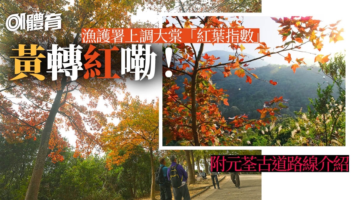
At the end of the trail, you can branch off and head to Datang Mountain Road, which is a popular place to admire the red sweet gum trees in winter (approximately mid-December). When the leaf viewing season comes, there are many tourists.
[Fisheries and Conservation Department raised the red leaf index on December 11]
Extra screening in the same scene! "Animal Hill" in Hong Kong: (click to enlarge)
+13
+13
+13
🏃🏽♂01Sports hiking page: introduction to the beautiful scenery introduction equipment interviews🏃🏾♀
🏃🏽♂Look at the route before hiking: Curry Mountain hiking guide🏃🏾♀
🏃🏽♂Subscribe to the 01 Sports Youtube channel now to learn more about hiking and sports🏃🏾♀
Facilities: information signs, toilets, poles, barbecue sites, picnic sites (Editor's note: during the epidemic, the barbecue and camping sites in country parks will continue to be closed).
Traffic information
Starting point: Take KMB No. 30 (get on at MTR Lai Chi Kok Station), No. 30X (get on Whampoa Garden or MTR Prince Edward Station), No. 39A (get on MTR Tsuen Wan or Tsuen Wan West Station) or 39M No. (get on the train at MTR Tsuen Wan Station), get off at the Hong Kong Adventist Hospital Station and walk to the starting point.
End point: Go down Tai Tong Shan Road for about 30 minutes to Tai Tong, and take MTR Bus No. K66 (to MTR Long Ping Station) or public light bus (to Yuen Long Thousand Color Plaza).
Note: In the middle of Yuanquan Ancient Road, there is a fork near your location "JK973 783" to the direction of Qingkuaitang Village. Follow this road for about 45 minutes to reach Sham Tseng.
Yuan Tsuen Ancient Road Country Trail Marking Pole from C6101 to C6126.
For more references of Yuan Tsuen Ancient Road hiking trails:
[New Territories Hiking Route] Long-distance recommendation for novices!
Yuanquan Ancient Road, enjoy the scenery of small bridge and flowing water
[Tsuen Wan Hiking Route] View the Tsing Ma Bridge and explore the abandoned school of Lianhuashan via the Shilong Arch on Yuan Tsuen Ancient Road
[Taitang Red Leaves Hiking Route] Go down Yuan Tsuen Ancient Road to Yuen Long Fengxiang Forest and turn back to Sham Tseng Downhill
Don’t check in for couples who are "going and you going", click the picture to enlarge:
+4
+4
+4
If you don’t know the way while hiking, what do you rely on when you want to find the way?
+3
+3
+3
Hiking route (screenshot of the field trend webpage)
New Territories Hiking Route|Starting from Sham Tseng to Qingkuai Tong, visiting the Hidden World Farm, strolling on the ancient road to Yuen Long Downhill
[Hiking Route in the New Territories] Tuen Mun Station issued a wheat trail to visit Qingjing Terrace in Thousand Island Lake and then drop off at Tai Tong, Yuen Long
[Yuen Long Hiking Route] Starting from Tai Tong, we will walk around the five small hills and go up to the Hok Hill to see the changes of Kam Tin Plain
[Xingshan] Zhou Jiayi incarnates as a mountain girl and goes to two major scenic spots in Dongpingzhou to check in at Maogong Cave in Zhanjingzhou
Hiking in the mountains|Zeng Shuya Jumbo teaches you to go up to Ciyun Mountain in 3 minutes, even the dog Bubu can easily complete it
[Hiking Route on Hong Kong Island] Ascending Nie Gaoxin Mountain to explore the mask stone chamber is a short distance but has to climb a sandy road
Lantau Island Hiking Route|Ngong Ping Wonderful Trail within 1 hour to enjoy the spectacular wonders of the Heart Sutra
[Taipu hiking route] Taihe started to climb up to Magang Sifang Mountain, but the mountain roads are rough
Hiking | Camping boom!
Sanyou occupied the helipad camping, and the gate of Donglong Island became a "refugee camp"
[The article is reproduced from "Wild Guide-HK Discovery", original text: Yuan Tsuen Ancient Road Country Trail]
[野Guide] Diversified online magazine platform!
Explore the world with the concept of [Hong Kong people's vision, Hong Kong people's footprints]. You like hiking, camping, sports running, green living, ecological conservation and in-depth travel!
Hiking in the mountains