
On December 10, 1520, the expedition of Magellan and Elcano crossed the now called Strait of Magellan and faced the unknown vastness of the Pacific Ocean.
Exactly five centuries later, Google has entered the V centenary of the first circumnavigation of the Earth with all its technological artillery.
Google Arts & Culture, in collaboration with the Ministry of Culture and Sports of Spain and the Spanish National Commission for the First Round the World Tour, has just launched a digital portal that explores the details of that feat that lasted three years (from 1519 to 1522 ), and its impact on the European understanding of the enormity of the Earth.
All through 1,000 images, 73 digital reports and 12 participating cultural institutions.
enlarge photo Map of the Magellan route from one of the atlases by Battista Agnese (1544).
It is called
The First Round the World
and, thanks to the project, users from all over the planet will be able to delve (virtually, of course) into the details of the voyage, dive among documents and historical maps, accompany the protagonists on their route and visit the replica of the only ship that returned to Seville, the nao
Victoria
.
It also allows us to know the communities that inhabit the places we would reach if we repeated such a journey today.
"The exhibition is divided into three pillars that try to explain not only the naval adventure but the before, after and its consequences, which continue to this day," say sources from Google Arts & Culture.
The first,
Expedition,
tells the details of the preparation of the feat, what the five ships were like, the crew, their key protagonists and the historical context.
Exploration
shows the maps and instruments that the explorers used, and the flora and fauna that they encountered along the way.
Finally,
Transformación
analyzes the legacy of that trip that, in the words of the organizers, left "a spherical world interconnected through the oceans, cultural, social and commercial exchanges".
enlarge photo The Seville of 1519, illustrated by Arturo Redondo.
Seville and Sanlúcar de Barrameda in the 16th century
The illustrator Arturo Redondo has drawn two interactive maps for the occasion that allow us to explore what Seville and Sanlúcar de Barrameda were like in 1519, the two departure ports of the expedition and which are part of the project
The First Round the World
.
On August 10, 1519, the expedition commanded by Fernando de Magallanes left the port of Seville.
His objective: to go in search of a new route to the west towards the islands of the Spice, or the Moluccas (Indonesia).
It was made up of five ships -
Trinidad, San Antonio, Victoria, Concepción
and
Santiago
- and a crew of 245 sailors, including Castilian, Portuguese, Greek, French, Italian, Belgian (Flemish), English or German.
Only the
Victoria
returned to Seville in 1522, commanded by Juan Sebastián Elcano, with 35 men on board.
Behind it left 1,084 days of navigation, 46,270 nautical miles traveled (about 85,700 kilometers, more than double the earth's circumference), a given round the world and the empirical verification that the oceans were interconnected and that the Earth was round.
"We have discovered and rounded all the roundness of the world," Elcano wrote to King Carlos V from Sanlúcar de Barrameda once his feat was completed.
The ship 'Victoria'.
A (virtual) walk through a replica of the
Victory
The replica of the
Victoria
, the surviving ship of the Magallanes-Elcano expedition with 26 meters in length and 6 in beam, can be visited digitally, in 360 degrees, thanks to Street View technology
(click here to see it)
.
From its sails (six, with a total area of 286 square meters) to the cellar, passing through the deck, with the mainmast, the winch, the lantern or the forecastle.
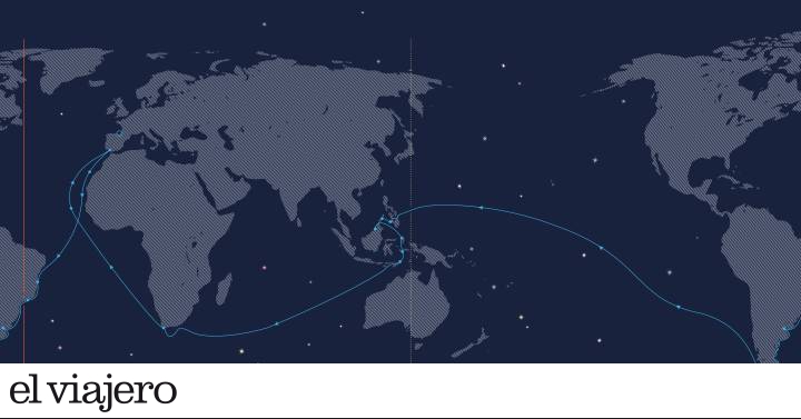
The route
The user can follow
the journey
on
a complete map
: the journey along the African coast;
the arrival, on November 29, 1519, to Brazil, with a stopover in Santa Lucía Bay (in present-day Rio de Janeiro);
or the trip through Tierra del Fuego (they named the territory that way when they saw the bonfires lit by the natives).
On November 28, 1520, in Cabo Deseado, the ships
Trinidad, Concepción
and
Victoria
found the passage to the South Sea: it is the Strait of Magellan, 565 kilometers long that took 38 days to cross, going from the Atlantic to the Pacific.
New Guinea bird of paradise.
After 100 days sailing the largest ocean on the planet, they arrived at the Mariana Islands (eastern Philippines, southern Japan);
on April 27, 1521, Magellan died in battle, in Cebu (Philippines);
On November 8, 1521, two years and three months after their departure, they reached the Moluccas.
On January 25, 1522, Elcano undertakes, from Timor, a solo return, nonstop, westward, across the Indian Ocean.
In the spring of that year the Cape of Good Hope bends.
Later it would arrive in Cape Verde, Canary Islands.
And, on September 8, it docks in Seville.
Mapping the New World
The Google Arts & Culture collection reproduces cartographic maps with high quality that show the transformation of the European vision of the planet after the expedition of Elcano and Magellan.
For example, the map of Juan Vespucio, from 1526, already incorporates the Strait of Magellan, although he calls it Sant Anton.
Find inspiration for your next trips on our Facebook and Twitter and Instagram or subscribe here to the El Viajero Newsletter.


