
This is New Jersey after the snowstorm 3:50
(CNN) -
Some places in the United States where snow doesn't usually fall could have an unexpected white Christmas this year due to a snowstorm.
It may be normal up north, but places as far south as the Tennessee Valley might wake up to snow on Christmas morning, too.
Chattanooga and Knoxville, Tennessee;
Asheville, North Carolina;
and the North Georgia Mountains might have some snow.
Higher elevations will get more accumulation, but places like Knoxville, which will likely have snow on Christmas Eve, historically only have a 3% chance of a white Christmas.
The snowstorm at Christmas moves east
This is all part of a larger storm system that is getting stronger and could cause major problems across the entire east coast of the United States.
Throughout Wednesday, snow will fall across much of the Midwest.
Extreme winds will also be experienced there.
Winter storm watches are in effect for much of eastern North Dakota, Minnesota, and parts of northwestern Wisconsin.
Blizzard conditions are possible through Wednesday in central North Dakota.
"Winds can reach gusts of up to 95 km / h, causing significantly reduced visibility in snow," according to the National Weather Service.
advertising
As the storm moves east, it will be primarily a source of rain.
Christmas Eve will be wet for millions of people from upstate New York to northwest Florida.
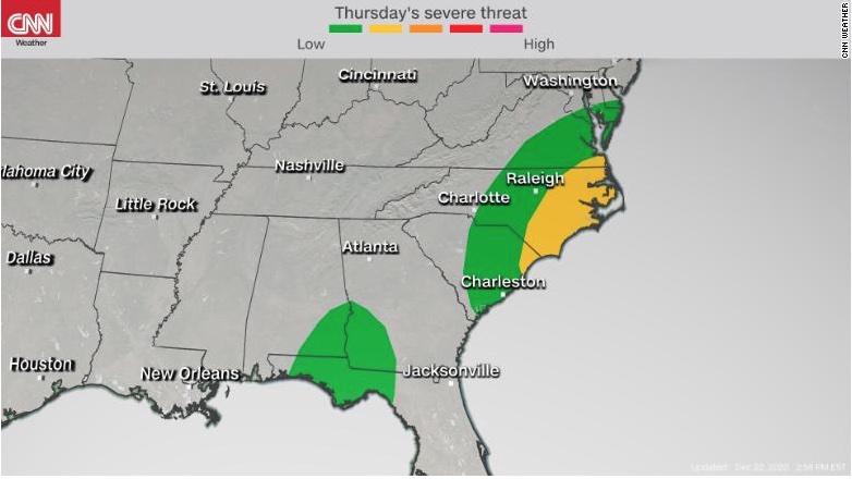
There could even be some severe storms.
"Last minute shoppers should be on the lookout for fast-moving storms," said CNN meteorologist Gene Norman.
“This storm configuration could easily allow dangerous winds and even some brief, isolated tornadoes.
Especially at risk on Christmas Eve are the eastern sections of North and South Carolina, southern Georgia and Alabama, and parts of northwestern Florida.
From the Ohio Valley to the Tennessee Valley, the rain will turn to snow Thursday afternoon.
Much of West Virginia and eastern Ohio could see 3 to 5 inches of snow, and higher elevations could see even more.
For large cities in the Northeast, the expected rain causes concern for places that already have snow on the ground.
In New York, the Binghamton National Weather Service office warned residents: “In places where it recently snowed heavily, this could add weight to the old snow cover on roofs / structures, causing structures to collapse. ».
Rain that follows snow can also cause rapid melting and flooding.
Snow showers today and tonight.
Quiet Wednesday.
Focus remains on Thursday and Friday.
Heavy rain and rapid snowmelt Thursday increase risk for ponding and adds weight to old snow pack on structures.
Snow late Thursday night and wet surfaces quickly ice over.
#nywx #pawx pic.twitter.com/I0DcQYCHrK
- NWS Binghamton (@NWSBinghamton) December 22, 2020
The storm will clear for most in the morning, leaving a cold and windy Christmas in the south, but parts of the northeast will be quite warm.
"Boston has a high mid-forecast of about 10 degrees Celsius on Friday, which is not only 10 degrees above normal, but it also means that Christmas Day will be warmer than Halloween in Beantown," the CNN meteorologist said. Allison Chinchar.
Millions travel for Christmas despite the pandemic
Despite the covid-19 figures being at their highest, people are still taking air travel.
The Transportation Security Administration (TSA) said Monday it screened more than a million people at airport security for the third day in a row, which is the first during the pandemic.
"1,064,629 people passed through checkpoints across the country on Sunday," the TSA said.
This means that 3.2 million people flew in three days.
On Wednesday, we could see delays in Minneapolis and Duluth, Minnesota, and Grand Forks, North Dakota.
On Thursday, the delays will be felt throughout the southeast due to the rains.
This includes New Orleans, Jackson, Mississippi, and Atlanta.
Snow delays will occur in places like Knoxville, Cleveland and Pittsburgh.
Travel delays are expected throughout Southern California for the next few days, due to high winds from Santa Ana on Wednesday and Thursday.
For Los Angeles and Ventura counties, winds will blow between 65 and 95 km / h with low humidity.
This will exponentially increase the potential for fires and lead to an increase in existing fires.
Snowstorm USA