
NASA images show effects of climate change 0:40
(CNN) ––
As we roll into the New Year, it's easy to see that things changed for many people in 2020, not least due to weather events.
LEE: 2020 was to be the year of climate action, instead it crowned a lost decade
In addition to bringing a deadly pandemic, 2020 also reminded us of the severity of the climate crisis facing the world.
Droughts, floods, heat waves, forest fires and hurricanes continued to affect the lives of communities around the world.
Besides –– and despite–– the challenges posed by covid-19.
Images of some of these weather events - visually astonishing and sobering in equal measure - were captured by NASA's fleet of Earth observation instruments and satellites.
Devices found on the International Space Station.
Unprecedented forest fires, among the climate events of 2020
On January 4 of last year, NASA's medium-resolution imaging spectroradiometer recorded images of the thick grayish smoke drifting across southeastern Australia.
The photos were taken as the country was devastated by one of its worst wildfire seasons on record.
The fire season in Australia is always dangerous.
But the conditions of the weather event were unusually severe in 2020. In fact, they led to the flames being fanned and the fire fighting circumstances especially difficult.
advertising
Experts say that climate change has worsened the scope and impact of natural disasters, such as fires and floods.
The climatic conditions are more and more extreme.
And, for years, the fires have started earlier in the season and have spread with greater intensity.
This natural color image of southeastern Australia was taken on January 4, 2020, by the NASA Medium Resolution Imaging Spectroradiometer on NASA's Aqua satellite.
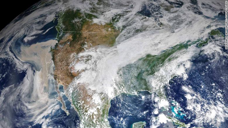
2020 was also a year many residents of the US West Coast states will remember. There, deadly wildfires in California, Oregon and Washington forced thousands of people to seek shelters amid the coronavirus pandemic.
In the image below, taken on September 9, a thick layer of smoke can be seen along the west coast.
This image shows the United States on September 9, 2020, as a thick layer of smoke covered the west coast.
“Fire and weather scientists long anticipated that fires in the western US would be bigger, more intense and more dangerous.
But even the most experienced were left speechless when describing the scope and intensity of the fires that burned in states on the west coast during September 2020, "NASA said.
Several of the fires this year were sparked by lightning.
But the extreme conditions caused fires to wreak havoc in nearby forests and, ultimately, in homes.
Among these conditions were record temperatures, dry air, fierce winds and droughts.
LOOK: What triggered the "apocalyptic" fires on the west coast of the US?
Sensors from the Visible Infrared Imaging Radiometer Suite (VIIRS) and the Ozone Mapping and Profiler Suite (OMPS) collected daily images of the thick columns of aerosol particles moving across the western US. According to NASA, the phenomenon was on a scale that satellites and scientists can rarely observe.
The two instruments are located on the NOAA-NASA Suomi NPP satellite.
Droughts
On July 3, 2020, the Operational Land Imager on Landsat 8 captured this false-color image of the river near Rosario, a key port city in Argentina.
This image appears to show a lush green oasis.
But in reality, the photo captured by NASA's Landsat reveals the dry basin of the Paraná River in Argentina.
A prolonged period of unusually warm weather and drought in southern Brazil, Paraguay and northern Argentina caused the river to decline to its lowest levels in decades.
The drought has contributed to increased fire activity in the surrounding delta and floodplain areas.
It has also affected businesses and local residents, who see their boats run aground.
In addition to low water levels that cost millions of dollars in the grain industry.
LEE: The last decade was the hottest recorded on Earth, exposing the grim reality of climate change
Human activity has been linked to the risk of drought in the world since the beginning of the 20th century.
Greenhouse gases generated by power plants, agriculture, cars, trains, and human activities in general have influenced the risk of droughts.
And experts predict that climate change-related droughts will get worse.
Hurricanes
Hurricane Laura, one of the 10 strongest hurricanes to make landfall in the United States, ripped through southwestern Louisiana in August.
Furthermore, it claimed the lives of at least six people and left a wide path of destruction in its wake.
MIRA: Covid-19 and climate change make hurricanes more devastating for Latin America
The 2020 Atlantic hurricane season was the busiest ever on record.
Additionally, many of the storms that hit the Gulf Coast, Central America and the Caribbean last year showed signs of being reinforced by global warming.
The Visible Infrared Imaging Radiometer Array (VIIRS) on NOAA-20 captured this image of Hurricane Laura at 2:20 am Central Daylight Time on August 26, 2020.
In the image above, captured by VIIRS on the NOAA-20 satellite, the storm looms off the coast of the US It is highlighted by the darkness of night, while the clouds are shown in infrared using data brightness temperature.
Also, the photo was overlaid with images showing the city lights.
Hurricanes Forest fires NASA Satellites Drought