
Community topics
Written by: Mo Jiawen Cai Zhengbang
2021-03-21 13:45
Last update date: 2021-03-21 13:45
Shaluowan, Lantau Island, was previously revealed to have illegally expanded roads and closed the village by gates. The government later gazetted the draft plan for the approval of the development of Shaluowan and Tentou. The consultation period ended earlier this month, and the villagers of Tentou village who were included in the planning sued 80% Semi-private land is zoned as a green belt, including farmland that has been cultivated for more than 60 years, as well as old housing plots that are planned to be rebuilt. Villagers have even accused the government of random planning and allowing houses to be built on "killing slopes."
They emphasized that they only want to preserve the village and attract villagers to return to restore the farming ecology, not to develop small houses.
Some conservation groups support the government's measures, but suggest appropriate planning for rural development, such as "agricultural land use", without excessive restrictions.
According to the Shaluowan and Tongtou Development Approval Area sketches published by the Town Planning Board earlier, the planned area covers an area of 155.92 hectares, covering the entire Dongao Ancient Road from Tongtou to Shaluowan. The spokesman said that due to the emergence of this area Human interference such as widening of pedestrian paths and roads and slope cutting works may affect the natural environment and rural characteristics of the area.
In order to avoid the further proliferation of inappropriate uses and further damage to the natural environment and rural characteristics, there is an urgent need to formulate a development approval area map for temporary planning control. The consultation period has ended on the 8th of this month, pending the Town Planning Board After review, the outline zoning plan will be formulated.
In one of the "planned" villages of Tentou, a group of villagers and outlying island district councillor He Shaoji held a press conference a few days ago to lodge a major complaint.
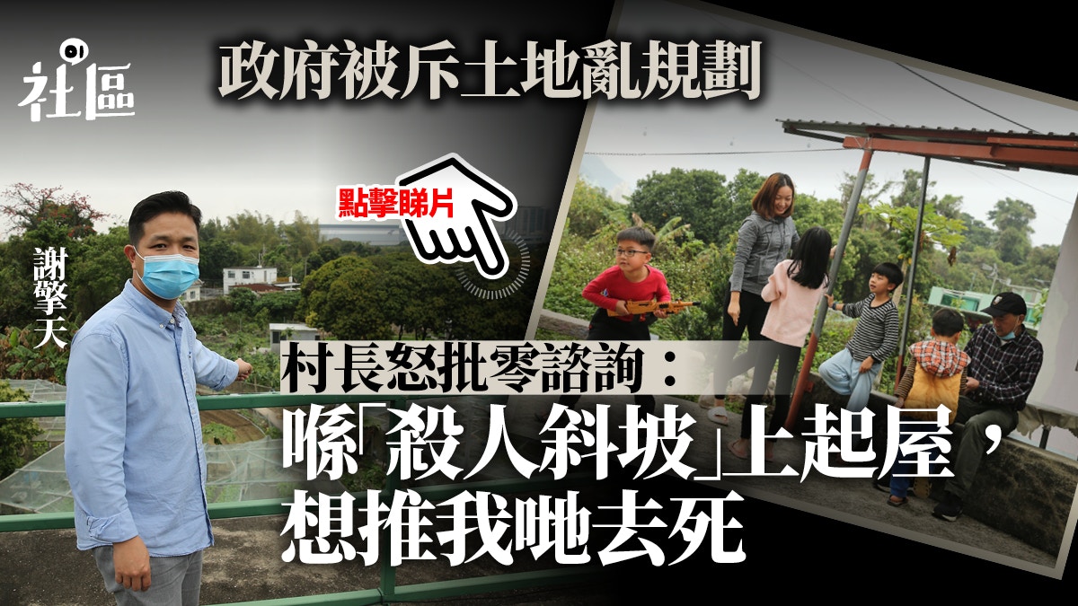
Village Chief Xie Qingtian said that Tentou Village has a history of more than 300 years. It used to be farmland and seafood for subsistence. As the next generation lacks job opportunities and the geographical location is remote, they move out. The current resident population in the village is about 100. , Living in about 30 village houses, and the remaining about 40-50 old village houses collapsed due to disrepair and need to be rebuilt before they can be occupied.
Tentou Village has always been committed to preserving the original rural ecology, with the goal of sustainable development of farming and seafood.
(Photo by Cai Zhengbang)
Dentou Village is not closed like Shaluo Village, allowing outsiders to pass the village road along the Dongao Ancient Road.
(Photo by Cai Zhengbang)
Villagers said that 80% of private land was "planned" without consultation
Village Chief Xie said that since the reunification in 1997, some villagers have applied for the redevelopment of old houses, but they have been frozen by the Lands Department. After complaining to the Legislative Council in 2017, they can reapply after being replied by the Lands Office. Some villagers try to enter the paper again. However, there is still no news until the government suddenly announced the Sha Lo Wan and Tentou development approval area sketches a month ago, which included 80% of the private land in the village, including the villagers’ old housing and agricultural land, into the green belt. There was no prior notice. Asking the villagers for their opinions surprised them.
"There have been two landslide records. It is not a suitable place to build a house. In the 1960s, Typhoon Wendai collapsed in the landslide, and some villagers were unable to avoid their lives. They told us to save our small house. In fact, we were pushed. Go to hell."
Xie Qingtian, Mayor of Tentou Village
Xie criticized that the planned area in the draft is extremely unreasonable. For example, many of the villagers’ farmlands are designated as green belts, some of which have been cultivated for about 60 years. How old is it." He worries that after the area is designated as a green belt, the farming life will not be able to continue.
In addition, some villagers worry that many old houses are zoned as green belts, and once they are included in the country parks, they will not be able to build houses. The government has compensated for another land as a "v zone" small house, but it is in a collapsed area. On the green slope of the landslide period, "There have been two landslide records. It is not a suitable place to build a house. The landslide collapsed during Typhoon Wendai in the 1960s, and some villagers were unable to escape. When I start a small house, I actually push us to die."
If the old house is zoned as a green belt,
Regarding the external complaints that Shaluowan illegally expanded roads and closed down villages earlier, the early announcement of the draft development approval area was to prevent people from using the right to continue to get up and damage the environment. Xie explained that the villagers did not intend to turn the village of Tentou from the beginning to the end. The small house owners, instead, reverted to the old rural ecology. Long before the draft was announced, they contacted the Changchun Club and the university groups, hoping to restore farmland and preserve the rural ecology. Many villagers also applied for the greenhouse license. The start of construction can be started by issuing the start-up paper. However, government departments have been adopting the tactics of dragging words. Until recently, when the relevant plans were announced on the Internet, the villagers had just awakened from a dream, saying bluntly, "Don't talk about conservation. Even farming and rural life may be wiped out. "The government's one-size-fits-all plan is like "a pan of cold water dripping down."
District Councillor: The government should not create opposition
The Islands District Councillor Ho Siu-ki said that if the old housing estate is zoned as a green belt, if the villagers apply for redevelopment, it will be extremely difficult to construct the environmental assessment and other conditions. If the green belt is included in a country park, it will be "neither. Do it.” Now the city planning committee only has a consultation period of less than three months. It does not communicate with the villagers in a virtuous manner, and only follows the procedures. If the villagers act violently like Shaluowan Village, it will only cause confrontation and affect everyone. No benefit. I hope that the villagers will communicate with the government in a reasonable way this time, hoping to gain understanding and attention from the outside world.
"Returning to the literature, there used to be rice in Nittiao Village. If it can maintain the original farmland, it will have a certain effect on the rural conservation ecology."
Su Guoxian, Director of Changchun News Agency
Environmental protection groups: Reserve farmland for moderate development
Su Guoxian, director of Changchun News Agency, said that Tentou Village contacted them through a university scholar about before the Lunar New Year, saying that the villagers had noticed that in recent years, outsiders had been digging for mudflat seafood, resulting in a sharp drop in shellfish seafood. For ecological conservation, the group initially plans to conduct a scientific research survey to conserve abandoned agricultural land rich in ecological resources, and the rest can be used for rehabilitation or public education. It described that villagers "have the idea of sustainable renewable resource utilization, which is better than other villages. advanced."
He also said that as an environmental group, he will definitely support the Sha Lo Wan and Tong Tau development approval area plans, but he believes that even if agricultural land is zoned as a green belt, the Planning Department should list its uses in detail, such as imitating the private land green belt in Lai Chi Wo , Allow farming but not use it for housing, restrict non-agricultural development, and maintain "agricultural land for agricultural use", which will not waste resources, but can also be appropriately reserved under the premise of protecting the environment.
"Returning to the literature, there used to be rice in Nittiao Village. If it can maintain the original farmland, it will have a certain effect on the rural conservation ecology."
One of the unreasonable aspects of the Sha Lo Wan and Ten Tau development approval area drafts is that a slope that collapsed and killed people was once designated as VZONE, which can be used for small house development.
(Photo by Cai Zhengbang)
The Planning Department replied that the current area of Tentou Village is mainly located in the "Sha Lo Wan and Tentou Development Approval Area Draft No. DPA/I-SLW/1" and is zoned as "Unspecified Use".
Prior to the preparation of the draft development approval area, Sha Lo Wan and Tongtou areas (hereinafter referred to as the "area") were not covered by statutory plans and were not within the scope of country parks. However, the adjacent country parks are an important part of the natural forest land system. section.
In order to prevent the emergence of disorderly and unregulated development projects that affect the rural natural features of the area with important scientific and conservation values, it is necessary to prepare a development approval area map covering the area for the Planning Department to prepare the outline zoning plan Before the map, it can make temporary planning control for the area and take enforcement control actions to deal with illegal development and inappropriate change of use.
The draft development approval area is currently the only statutory plan in the district. However, the draft development approval area is only a temporary plan and will later be replaced by an outline zoning plan showing detailed land use zones.
In order to determine a suitable land use zone for the area as soon as possible and consult the public in due course, the Planning Department has expedited the preparation of the outline zoning plan and submitted the "Sha Lo Wan and Tong Tau Zoning Plan" to the Town Planning Board on January 15 this year. The draft outline was considered for preliminary consideration, and the Town Planning Board agreed to use the draft outline for consultation.
The draft outline zoning plan aims to define a general land use zone for the district so that the district can be included in the statutory planning control, and at the same time provide a planning outline for guidance.
When formulating various land use zones, the Planning Department will consider different planning factors.
The Department is currently consulting the relevant rural committees, outlying island district councils and relevant stakeholders on the draft outline and the proposed land use zones. The opinions collected will be submitted to the Town Planning Board for further consideration.
After obtaining the approval of the Town Planning Board, the relevant draft outline zoning plan will be gazetted in accordance with Article 5 of the Town Planning Ordinance to replace the relevant draft development approval area, and a statutory public consultation will be conducted during the two-month display period.
The Lands Department responded to reports that some villagers were asked to move to other land for redevelopment or to build small houses, stating that the Outlying Islands Lands Office is processing 6 applications for redevelopment of village houses in Tongtou Village in accordance with established procedures. The earliest application was submitted in 2017.
When processing an application for village house reconstruction, the Lands Administration will consult relevant departments, but will not require the applicant to relocate the reconstruction site.
Shusha Lowan Village is "closed" again. The Town Planning Board announces 4 draft plans for development approval for the 4 districts on Lantau Island
Shaluowan Village was closed twice, and now only half of the gate is left. The city planning committee gazetted the "tightening curse"
Village in Shaluowan | Two gates were demolished for illegal construction
Shaluowan closes the village | The land administration office demolishes the illegal gates one week after the villagers re-implemented the old tricks
01Community
Outlying Islands Community Urban Planning Policy Planning Environmental Protection Community Conservation Planning Department Lands Department