the weather
Written by: Lao Minyi
2021-04-11 13:45
Last update date: 2021-04-11 13:53
Hong Kong has been overcast and sunny recently. This morning (11th) Tai Mo Shan dropped to 12.2 degrees Celsius, and thereafter it ushered in sunny weather.
The Observatory predicts that a fresh to strong easterly airstream will affect Hong Kong in the middle and late part of this week. It is expected that there will be rain for five consecutive days from Wednesday (14), and there will be sunshine only next Monday (19). The next day ( 20th) The "Gu Yu" of the 24 solar terms also had sunshine for a short time.
In addition, the Observatory previously predicted that Hong Kong has a chance to enter the windy season before June. In the European and American weather forecasts, tropical cyclones will be generated in the sea east of the Philippines later in the next week and will be upgraded to super typhoon levels. The US forecast is expected to move to Japan. East area.
▼In October 2020, ``Langka'' struck Hong Kong as the No. 8 typhoon, the farthest typhoon in nearly 60 years▼
+13
+13
+13
It is expected to reach 30 degrees or above in many districts on Tuesday, and there will be wind and rain on the 5th next Wednesday.
The easterly air currents affecting the coast of Guangdong are gradually easing. Today, the weather in Hong Kong is generally fine, with temperatures ranging from 21 to 26 degrees. The afternoon is dry with gentle easterly winds. At first, offshore winds were fresh.
Affected by the high-altitude anticyclone, it will bring generally fine weather to the south China coast in the next one or two days. The Observatory expects sunshine on Monday and Tuesday (12th and 13th), and the highest temperature in the urban area is expected to rise to 29 degrees.
With reference to the automatic regional weather forecast, on Tuesday afternoon, the temperature rose to 30 degrees or above in most areas, with the temperature rising to 32 degrees in Sheung Shui and Ta Kwu Ling.
An easterly airstream with fresh to strong winds will affect the coast of Guangdong in the middle of the week, causing rain in the area.
The Observatory predicts that it will be cloudy and rainy from Wednesday to next Sunday. At the beginning of Thursday, the offshore wind will reach level 6 and the wind will reach Typhoon No. 3. After that, the wind will ease slightly, and there will be strong winds on next Sunday. The lowest temperature in the urban area is expected to drop to 21 degrees, weekend holidays should be spent on cloudy days.
The observatory predicts that the sun will return early next week.
Next Tuesday (20th) is the "Guyu" in the 24 solar terms. It is the last solar term in spring. The weather will be warmer before and after the "Guyu" and the rainfall will increase.
The Observatory expects sunshine for a short period of time that day, and the temperature in the urban area ranges from 22 to 26 degrees.
▼ECMWF forecast▼
▼GFS forecast▼
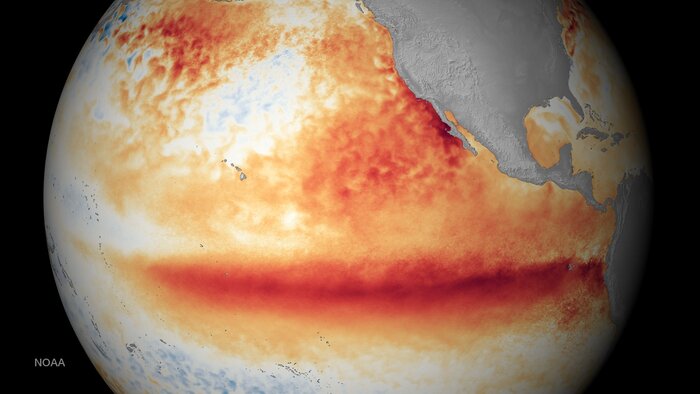
European and American forecasts predict tropical cyclones will form east of the Philippines
In addition, referring to the European Center for Medium-Range Weather Forecast (ECMWF), a tropical cyclone will form in the sea east of the Philippines on Thursday (15th), and then gradually strengthen, until next Tuesday (20th) its lowest sea level pressure is only 919hPa, then It has reached the level of a super typhoon, but by then it has not crossed the Philippines and entered the South China Sea, moving northward.
The US Global Forecast System (GFS) predicts the same, but predicts that its movement path will be even further away from Hong Kong, and it is expected to move to the east of Japan.
▼In August 2020, ``Hygoss'' attacked the port from No. 1 to No. 9 typhoon in 22 hours▼
+11
+11
+11
Fighting wind in April?
Europe and the United States expect tropical cyclones east of the Philippines to form an observatory next week: big variables remain
A tropical cyclone is expected to form east of the Philippines next week. Will the Observatory’s interpretation draw usher in the "April Wind"
The weather forecast will increase the probability of significant rainfall today. The Observatory will announce heavy rain in some areas in the next season.
The Observatory expects up to 8 typhoons to hit Hong Kong this year is normal or it may have entered the windy season before June
01News
Hong Kong Observatory Weather Forecast