Of the three valleys of Haut-Béarn, Ossau, Aspe and Barétous, the first is more often in the spotlight. The great totem pole of the Pic du Midi is probably not for nothing. The other two, more discreet, pride themselves on cultivating a preserved and authentic mountain life. But all find themselves in their good old rivalry with the Basque cousin. Because here, we are proud to be Béarnais. This through hike from the
Aspe Valley
to
Ossau Valley
can approach closer to the giant Bearn.
Isolated from the rest of the massif, the mythical mountain is perhaps not the highest in Béarn but nevertheless commands respect.
The locals prefer to call him "Jean-Pierre" as if to attract his good graces.
After a circumambulation that allows you to contemplate this monument from all angles, hikers who have been sufficiently far-sighted to drop a car there will be able to exit at Lake Bious-Artigues.
The others will take the vertiginous Chemin de la Mâture towards the starting point in the Aspe valley.
Read also: Fresh air and good food, five beautiful villages in Béarn where to go green
The great tour of the Pic du Midi d'Ossau, hiking in practice
1st day: from the Chemin de la Mâture to the Ayous refuge by the GR 10
Difficult> 11 km> 5h30> +1,500 m / -250 m> GR red-white markings (see our practical guide to find your way around the course).
Departure: from the Passette car park (715 m) near the Fort du Portalet.
GPS point: N 42.892564, E -0.561854
2nd day: tour of the Pic du Midi d'Ossau
Difficult> 13 km> 8h> +1,050 m / -1,050 m> No markings
Exit: the small parking lot at Bious-Artigues lake (1422m)> GPS point: N 4749389, E 708436
IGN 1547 maps OT Ossau-Vallée d'Aspe - Pyrenees PN
Topo guide: Crossing the Pyrenees - Western Pyrenees - Basque Country / Béarn Ref.
1086
Fort Portalet
This curious building clinging to the side of a cliff on the right bank of the Gave d'Aspe blends almost incognito into the landscape.
Christophe Migeon / Le Figaro
In a few tight laces, the path is not long in dominating the austere walls of the Fortress of Portalet. The curious building clinging to the side of a cliff on the right bank of the Gave d'Aspe blends almost incognito into the landscape. Built by Louis-Philippe in 1842 to defend the Somport road and prevent any Spanish invasion through the Aspe valley, the site has never had the opportunity to play any military role. Alfred de Vigny stayed there in 1823 with his garrison and found there the inspiration of the famous French
Horn
.
The fortress is best known for having hosted several leading political figures for a few months under the Vichy regime: Blum, Daladier, Reynaud, Mandel, Gamelin… And other perfect scapegoats for defeat.
In the cells, these gentlemen still had hot water, toilets, a radiator, a fireplace and even shelves for their books.
At the Liberation, Pétain will in turn be able to benefit from this monastic comfort, since he will stay from August to November 1945 before his transfer to the Ile d'Yeu!
The vertigo of the mast
The Chemin de la Mâture, if it may seem intimidating, has been drilled wide and high enough to allow the passage of tree trunks pulled by oxen.
Christophe Migeon / Le Figaro
A long half-moon notch carved with a pickaxe scars the side of the cliff. Seen from below, the slash, open to the four winds and all the falls, inspires nothing good. And then, as often in the mountains, the approach allays fears. The
path of the mast
was drilled wide and high enough to allow the passage of tree trunks pulled by oxen. Between two snores of the stream escaping from the bottom of the Gorges d'Enfer 200 m below, we listen to the astonishing story of this vertigo corridor: the Royal Navy has always been greedy in fir trees for the masts or in beech trees for the oars. The beautiful forest beyond the Gorges had been identified by Colbert's engineers, but it was a century later under the leadership of Choiseul, that it was finally exploited thanks to the opening of this path on the side of ravine. The barrels, sometimes 30 m long, were then transported to the Gave d'Aspe before being floated to Bayonne. The passage will only be used for ten years by loggers, the time to cut down the most beautiful specimens.
Read also: In the heart of the Pyrenees, five experiences in a grandiose and unspoiled nature
The Ayous lakes show
On the banks stretched with soft grass, horses take a nap in an atmosphere of Central Asian meadows.
Christophe Migeon / Le Figaro
After a kilometer, the path stops flirting with emptiness and continues in the shade of the beech-fir forest. At the Baigt de St Cours hut (1,560 m) the trees have taken their leave and left the field open to vast lawns sprinkled with purple irises. The slope grows stronger as the roar of the herds rises from the valley. Suddenly, it's the Col d'Ayous and its breathtaking panorama: as hieratic as an Indian totem, the Pic du Midi d'Ossau storms the sky with, scattered at its feet, the jade pearls of the Ayous lakes. The giant is reflected in the mirror of the waters. On the banks stretched with soft grass, horses take a nap in an atmosphere of Central Asian meadows. A marmot yet accustomed to the panorama hissing in ecstasy. Ayous' refuge is theideal place to feast on this spectacle at dusk.
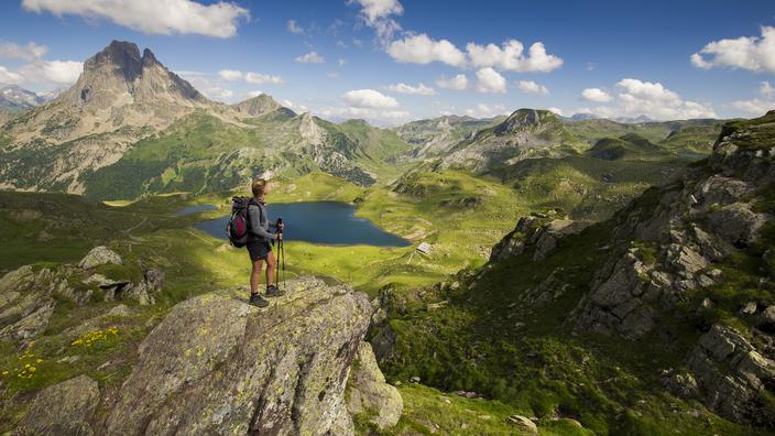
The pyramid of Ossau
If it is not the highest point of Béarn, the peak is distinguished by its singular volume and its magnetism.
Christophe Migeon / Le Figaro
Threatening fang, chipped by millennia of erosion, massive silhouette of a Mayan pyramid, grandiose eminence worthy of a Paramount credits ... The Pic du Midi d'Ossau does not lack allure.
However, this offshoot of an ancient volcano that was extinct several hundred million years ago is not even the highest point in Béarn (it is the Palas peak with 2974 m).
Its singular volume, its magnetism, some would say its aura, have nonetheless subjugated the whole valley.
The revolution around this phenomenon begins with a din of cowbells.
Between June and October, all the summer pastures around the plain of Bious are rented to the shepherds on payment of "bacades" (fees paid by the breeder per head of cattle) to the town.
End of loop
The meadow sizzles with blissful chirps emitted by a small world of grasshoppers and locusts drunk with heat.
Christophe Migeon
Further south, the trail climbs up to the Col de l'Iou, which delights its visitors with a view of the vaporous distances of Spain before branching off to the east. Under the grill of the sun, the meadow sizzles with blissful stridulations emitted by a small world of grasshoppers and locusts drunk with heat. Past the refuge of Pombie, the soles grope, panic and pull themselves together in a formidable scree while an Egyptian vulture (a “Marie-blanque” for the Béarnais) flies effortlessly over this end-of-the-world chaos. The path has never been so close to the giant and its double point of andesite. After the Suzon pass, its warm presence vanishes, as an eiderdown of clouds covers the entire valley and soon transforms the summer pastures into Scottish moors.All that remains is the Magnabaigt pass to find the car parked in the parking lot of the artificial lake of Bious-Artigues. Those who have not taken this precaution will just have to walk along the right bank of the lake and take the GR 10 towards the Ayous refuge.
Read also: Lourdes, the unmissable places for a rejuvenating stay at the gateway to the Pyrenees
Practical notebook
ROUTE
1st day: from the Chemin de la Mâture to the Ayous refuge by the GR 10
To the right of the car park, take the path that circles a rocky outcrop. We soon approach the most aerial part, on the side of the cliff. The path carved into the vertical wall is 2 to 3 m wide and people prone to vertigo can avoid looking at the bottom of the Gorges d'Enfer 200 m below (Sescoué valley). The climb continues, rather steep, until the junction towards the Trungas bridge formerly used to pass the logs from one bank to the other. Climb a small steep slope to the left and reach a crossroads. Continue to the right on a good path in the undergrowth. Pass the ruins of the Passette border and climb to the right bank of the Gave. Enter the National Park and reach the Baigt de St Cours hut (1,560 m). There is a fountain there. From the cabin,continue by the path which follows the right bank of the Gave then the left bank. Via pastures, reach the Hourquette de Larry pass (1 985 m). Climb to the south, passing under a rock face. Reach a first small pass (2,125 m) and continue to the left until the Col d'Ayous (2,185 m). Enjoy the view of the Pic du Midi d'Ossau and the chain of Ayous lakes. Descend by a winding path and arrive at a junction north of Lake Gentau. Continue to the right to the nearby refuge (1,982 m). For the next day, two possibilities: go the opposite way or go around the Pic du Midi d'Ossau with an exit to Lake Bious-Artigues where we will have taken the trouble to drop off a vehicle.reach the Col de la Hourquette de Larry (1 985 m). Climb to the south, passing under a rock face. Reach a first small pass (2,125 m) and continue to the left until the Col d'Ayous (2,185 m). Enjoy the view of the Pic du Midi d'Ossau and the chain of Ayous lakes. Descend by a winding path and arrive at a junction north of Lake Gentau. Continue to the right to the nearby refuge (1,982 m). For the next day, two possibilities: go the opposite way or go around the Pic du Midi d'Ossau with an exit to Lake Bious-Artigues where we will have taken the trouble to drop off a vehicle.reach the Col de la Hourquette de Larry (1 985 m). Climb to the south, passing under a rock face. Reach a first small pass (2,125 m) and continue to the left until the Col d'Ayous (2,185 m). Enjoy the view of the Pic du Midi d'Ossau and the chain of Ayous lakes. Descend by a winding path and arrive at a junction north of Lake Gentau. Continue to the right to the nearby refuge (1,982 m). For the next day, two possibilities: go the opposite way or go around the Pic du Midi d'Ossau with an exit to Lake Bious-Artigues where we will have taken the trouble to drop off a vehicle.Enjoy the view of the Pic du Midi d'Ossau and the chain of Ayous lakes. Descend by a winding path and arrive at a junction north of Lake Gentau. Continue to the right to the nearby refuge (1,982 m). For the next day, two possibilities: go the opposite way or go around the Pic du Midi d'Ossau with an exit to Lake Bious-Artigues where we will have taken the trouble to drop off a vehicle.Enjoy the view of the Pic du Midi d'Ossau and the chain of Ayous lakes. Descend by a winding path and arrive at a junction north of Lake Gentau. Continue to the right to the nearby refuge (1,982 m). For the next day, two possibilities: go the opposite way or go around the Pic du Midi d'Ossau with an exit to Lake Bious-Artigues where we will have taken the trouble to drop off a vehicle.Ossau with an exit to Lake Bious-Artigues where we will have taken the trouble to drop off a vehicle.Ossau with an exit to Lake Bious-Artigues where we will have taken the trouble to drop off a vehicle.
2nd day: tour of the Pic du Midi d'Ossau
Return to the GR. Continue on the right by the path which runs along the Gentau lake. Descend the hairpin bends along the spillway of the two lakes Gentau and Miey, pass Lac Roumassot and continue down the path through the pastures to the edge of the forest (1,704 m). Continue through the forest to the plain and to the Bious bridge. Go down to the right to cross the Gave de Bious over a concrete bridge. After the Bious plain, the trail winds up in the Arazures woods and joins the Peyreget valley. By a gradual climb, reach the lake of the same name. Continue to the Col de l'Iou (2194 m). The trail bypasses the Peyreget peak and leads to the Anéou crossroads shortly before the Soum-de-Pombie pass (2,129 m). Cross the pass and pass in front of the Pombie refuge (2,031 m) on the shores of the lake.The trail runs along the eastern shore of the lake, continues westward slightly uphill, then descends north. It crosses the great Raillère de Pombie then crosses pastures before going up to the Col de Suzon (2,127 m). The path descends first by the right bank then the left bank of the Gave de Magnabaigt towards the valley of the same name. Descend near a waterfall, then through a real rhododendron garden then reach the Long Col de Magnabaigt (1655 m). By a descent in the wood of Bious-Artigues reach the lake of the same name and find the car park.first by the right bank then the left bank of the Gave de Magnabaigt towards the valley of the same name. Descend near a waterfall, then through a real rhododendron garden then reach the Long Col de Magnabaigt (1655 m). By a descent in the wood of Bious-Artigues reach the lake of the same name and find the car park.first by the right bank then the left bank of the Gave de Magnabaigt towards the valley of the same name. Descend near a waterfall, then through a real rhododendron garden then reach the Long Col de Magnabaigt (1655 m). By a descent in the wood of Bious-Artigues reach the lake of the same name and find the car park.
GOOD ADDRESSES
Restaurant l'Arregalet.
If the “regalet” in Béarnais is a small stream, the arréquet is a piece of bread rubbed with garlic.
In this local restaurant, you will taste typical dishes such as the famous garbure, the dios (a cold meats made from the ear, tail, muzzle and rind) or miques made from corn and wheat flour.
L'Arrégalet, 37 rue du Bourguet 64440 Laruns.
Phone.
: 05 59 05 35 47.
The beret museum.
To finally know the real story of the most famous headgear in France which is in fact nothing Basque.
Free for individuals.
Beret Museum, Place Saint Roch, 64800 Nay.
Phone.
: 05 59 61 91 70.
The Tyrolean of Gourette.
2 giant zip lines of 200 m one way and 180 m return, installed on the valleys of Valentin, towards the GR10 (Col de Tortes).
July-August afternoons by reservation.
€ 7.
Phone.
: 06 89 87 26 66.
The Artouste train.
Open daily from May 13 to October 3, 2021. The gondola from Lac de Fabrèges (1250 m) takes you to the train departure station (1950 m) in 15 minutes.
Then boarding for a 55-minute train ride at an altitude of 2000 m.
Then 1 hour and 20 minutes of free time at Lake Artouste with the Discovery ticket (25 € adult), the day with the Escapade ticket (32 € adult).
Le train d'Artouste, Station d'Artouste, 64440 Laruns, Tel.
: 05 35 53 97 71.
Fort Portalet
.
The fort is closed for renovations for the year 2021. Otherwise, it can be visited by reservation at the Aspe Valley Tourist Office by telephone: 05 59 34 57 57. Visit of 2h30.
OR SLEEP
Lo Sauneï.
5 guest rooms in a beautiful wooden house 5 km from Laruns overlooking the Ossau valley.
From 62 € per night.
Lo Sauneï, Aste-Béon, 64260 Aste.
Phone.
: 06 40 99 41 86.
Ayous refuge.
In the heart of the Pyrenees National Park, this mountain refuge located at 1980 m is open from early May to mid-October.
No shower, only toilets and all supplies are done on the back of a man or a donkey.
25/30 places in dormitories, € 15 per night, € 42 half-board (night + dinner + breakfast).
Open from May 12 to October 10.
Refuge d'Ayous, Gabas, 64440 Laruns.
Phone.
: 05 59 05 37 00.
To know more :
The official website for Tourism in the Ossau Valley.
Phone.
: 05 59 05 77 11.