
Hail hit Texas hard (April 2021 video) 0:32
(CNN) -
A series of severe storms will threaten more than 33 million people in the southern plains of the United States this Monday, while the risk of flash floods will increase on Tuesday and Wednesday.
Hail is the greatest hazard associated with current storms in Texas.
"Giant destructive hail is possible, if not likely," said the National Weather Service (NWS) office in Midland, Texas.
Hail as big as baseballs could fall on a state that has already seen damaging hail events in the past month.
Check your local forecast
Severe hail and damaging winds in Texas and other states
advertising
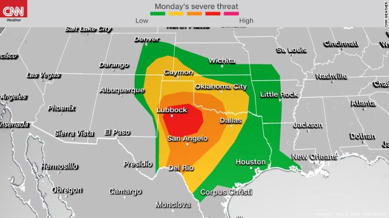
There is a “moderate” level 4 out of 5 risk for severe weather conditions in parts of West Texas, including Abilene and Lubbock.
This is the region most at risk for severe hail, but that threat extends from Colorado to Kansas and through the coastal sections of Texas and Louisiana.
Cities like Dallas, Fort Worth, Oklahoma City, Denver, Houston, Amarillo and San Antonio are included in the threat zone as of Monday night.
Rain and thunderstorms battered parts of Northeast Texas this morning, bringing heavy rain and frequent lightning, but severe weather conditions are not a major concern with this round of storms.
That will change as of Monday afternoon, however, as scattered thunderstorms rapidly form over parts of western Texas and eastern New Mexico and Colorado.
This is where the humid air from the Gulf of Mexico meets the very dry air from the southwestern desert.
These storms will be responsible for the hail, but there is also the risk of tornadoes.
These storms, especially in the early hours of their formation, will be supercells.
This type of storm spins and can sometimes produce tornadoes.
On Monday night, these supercell storms are expected to develop into a line of storms pushing eastward through much of Oklahoma and north Texas.
This line will have alerts for damaging winds, with gusts of up to 96-112 km / h.
Storms will also be possible further south in central Texas.
This is a nocturnal threat, so it is important that you have weather alerts configured on your phone in case a dangerous phenomenon passes through your city.
It's not until Tuesday morning that this first round of storms will weaken once it hits Arkansas.
Tornado watch was issued for parts of Texas and Louisiana in the US.
The severe threat continues much of this week
During the early hours of Tuesday morning, a secondary round of thunderstorms is expected to develop in west-central Texas, continuing east as it intensifies.
This will put the central and northeastern parts of Texas at risk of severe storms through Tuesday afternoon.
Large hail and damaging winds are possible with these storms.
Scattered thunderstorms are possible over the rest of the South Plains Tuesday afternoon before a possible third round of intense thunderstorms develops Tuesday night in central Texas and Oklahoma and continues through the Tuesday night.
The exact location and intensity of these storms is uncertain as this forecast depends on what happens to Monday's storms.
Cities like Dallas, Fort Worth, Oklahoma City, and Austin will need to be vigilant anyway.
The weather pattern that fuels these days of severe weather will be fairly stagnant, so additional thunderstorms, some of which could be severe, will continue to threaten the southern plains for much of this week.
Hit by a hail storm in Texas 0:51
11 million face flood risk
Flooding will be a growing concern in parts of the Deep South this week.
More than 11 million people are currently under flood warnings from the mountainous region of Texas through the Dallas metroplex and north to central Oklahoma.
"Flash flooding will continue to be a problem as heavy rains are anticipated," warned the National Weather Service office in Fort Worth, Texas.
“Parts of central Texas and the Brazos Valley could receive an additional 5 to 18 inches of rain.
Locally higher amounts, close to 8 to 25 centimeters or more, will be possible in much of North and Central Texas. "
Southerly winds on the southern side of a frontal boundary will introduce a large amount of tropical moisture during the week, flooding these areas with constant rainfall and the potential for flooding.
In addition, many of the storms to be unleashed will be slow, increasing the risk of flooding.
With heavy #rain occurring and forecast to continue across south-central sections of the country this week, it's important to understand the power of water.
It can be very difficult to judge how deep flood waters are and only 12 inches of water can carry away a small car.
pic.twitter.com/F46jR1pf2k
- NWS Weather Prediction Center (@NWSWPC) May 16, 2021
Several rivers and streams are already in a moderate flood stage, with several experiencing a rapid rise.
A location along the Sabine River, northeast of Dallas, saw a 4-meter rise in less than 24 hours, and this was the second time that happened in less than a week.
The heaviest rain is forecast for Tuesday and Wednesday, where there is a high risk of flash flooding.
This includes Dallas, San Antonio, Austin, and Houston.
Various locations in Texas could see more than 12 inches of rain.
The biggest forecasting challenge is determining where the heaviest rain will fall.
"It seems pretty safe to say that someone somewhere in the eastern half of Texas will be hit by a great deal of rain," said the National Weather Service office in Houston.
"The possibility of minor flooding due to slow storms producing heavy to torrential rains is also possible, although it is still difficult to know an exact location."
hail