
Social News
Written by: Zhang Jiamin
2021-06-10 00:00
Last update date: 2021-06-10 00:00
The government commissioned a consultant to conduct a brownfield study in 2017. Two years later, a report was issued stating that there are a total of 1,579 hectares of brownfields in Hong Kong, of which 450 hectares have development potential, but only 47 hectares of brownfields will eventually develop public housing.
The local research agency and Greenpeace found that there are about 1,958 hectares of brownfields in Hong Kong, which is a difference of 379 hectares from the government data. Some of the brownfields have expanded to country parks, and there are also missing brownfields that are close to the government’s finalized development. Group of brownfields.
Chen Kechun, the director of the Greenpeace project, pointed out that when the authorities did the research in 2017, they used the 2015 map as a benchmark. Outdated data made the research results "not the right product."
Cai Nuozheng, a local research agency, described the government's research on brownfields as "sighing slow", in a disguised form that it has promoted the spread of brownfields.
They suggested that the area of brownfields should be updated regularly, otherwise the government is not determined.
The local research agency and Greenpeace found that there are about 1,958 hectares of brownfields in Hong Kong, which is 379 hectares different from government data.
(Photo by Luo Junhao)
According to the Brownfield Report issued by the Planning Department at the end of 2019, there are 1,579 hectares of brownfields in Hong Kong. The report refers to the use of electronic vertical projection photos in 2015 as a base map and 1,300 hectares of brownfields were identified; aerial photography from 2017/18 was also used Pictures, satellite pictures, and planning information provided by the Lands Department.
The biggest difference in brownfields in Yuen Long is more than 25%
The Local Research Agency and Greenpeace used similar methods this year, and through field visits and planning permission applications from the Town Planning Board, they finally found that there are 1,958 hectares of brownfields in Hong Kong, which is 379 hectares more than the Planning Department reported.
Among them, the Yuen Long District has the largest gap. They estimate that there are about 1,331 hectares of brownfields in the district, which is about 285 hectares more than the government estimate of about 1,056 hectares, which is about 26% more; Tsuen Wan District, which is not included in the scope of government research , They also found about 4 hectares of brown land.
They estimate that if the additional half of the brownfield area is developed at a low-to-medium density, about 96,000 units can be built.
Xintian Brownfield Group expanded three times after 2015
Among them, in the brownfield group of Xintian Xinxinyuan, they found a total of 6 hectares of brownfields, and pointed out that they had expanded three times between 2017 and 2020.
As the government only bases its statistics on satellite images in 2015, it has "missed" about 2.5 hectares of brownfields in disguise.
During the site inspection, they also found the open storage yard and posted a notice of illegal placement of construction waste issued by the Environmental Protection Department in December 2019.
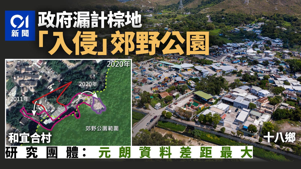
The brownfield of Heyihe Village has been extended to the country park.
(Pictures provided by Local Research Agency and Greenpeace)
Group reveals "Brownfield Chameleon" The brownfield at Dinosaur Pit, Sheung Shui "changed color" 3 degrees in 30 years
Extension of brownfields in Tsuen Wan to country parks
In Chuanlong and Wo Wo Yihe Villages in Tsuen Wan, part of the brownfield area involves green belts, and has been extended to country parks.
Among them, Chuanlong has 1.2 hectares of brownfields attached to the extension of the Tsuen Kam Highway and the country park boundary. Checking the Planning Department's map, some brownfields are not only located in the green belt, but even expanded to enter the adjacent country park.
Another example is also in Tsuen Wan, adjacent to Wo Yihe Village and Shing Mun Reservoir, involving about 1 hectare of brownfield land.
The brownfield is located in the green belt, and it increased from 0.2 hectares to 0.6 hectares from 2002 to 2020 and 18 years, and then gradually expanded to the Shing Mun Country Park.
Situation of brownfields entering country parks
The Sha Po brownfield complex amounts to 45 hectares
In addition, there are also missing brownfield sites for development projects adjacent to the authorities.
At Ma On Gang, near the entrance of the Tai Lam Tunnel, the government figures are about 6.8 hectares of brownfields. According to satellite photos from 2017/18, the private sector found 10.3 hectares of brownfields at the same location.
It is worth noting that the Planning Department announced in March the results of the second phase of the review of the brownfield cluster for public housing development. Among them, the site was selected on Kam Ho Road, which is right next to the aforementioned Ma On Gang brownfield cluster, and Kam Ho Road covers only 2 hectares. Of brownfields.
In the first phase of the government's brownfield study, 13 hectares of brownfield in Sha Po was identified for the development of public housing projects.
However, this private study also found that there is an expansion of brownfields in the area. At least 23 hectares of brownfields in the Sha Po area have been missed. If government information is taken into account, the area of brownfields in the Sha Po area is at least 45 hectares.
Newly expanded brownfield in Ma On Gang.
(Pictures provided by Local Research Agency and Greenpeace)
According to information from the authorities, there are 80 hectares of brownfields in the Santin/Lok Ma Chau development hub in New York. However, this study found that there are 4 hectares of brownfields in Pan Uk Village outside the boundaries of the development area, far more than the government's brownfield data. 0.4 hectares.
Among them, the area of brownfields has expanded by nearly 3 hectares since 2019.
It can be seen from the scene that there are mainly containers and trucks parked there, and there are low-density residential buildings near the missing brownfield.
+6
+6
+6
Chen Kechun, director of the Greenpeace project, pointed out that the brownfield research report of the Planning Department uses satellite images in 2015 as the base map, and the results of the research are "not the right product" because of the outdated data.
(Photo by Luo Junhao)
Groups approve government brownfield data outdated: wrong goods
Chen Kechun, Director of the Greenpeace Project, pointed out that the brownfield research report of the Planning Department used 2015 satellite images as the base map, which caused the authorities to omit and later expand brownfields. He questioned that the authorities did not make full use of existing information to confirm the data. It's not right".
Taking the brownfield group of Xintian Xinxinyuan as an example, she believes that the environmental protection department and other departments keep relevant brownfield information, reflecting that the government has enough information to confirm and update the data.
In addition, the authorities have not fully studied the scope of brownfields, resulting in the omission of brownfields in Tsuen Wan.
Cai Nuozheng, a researcher at the Local Research Institute, suggested that the government should update the brownfield information every year.
(Photo by Luo Junhao)
Our research agency denounces research on brownfield stalls that allow brownfields to expand out of control
Cai Nuozheng, a researcher at the Local Research Institute, pointed out that because the government began to study brownfields as early as 2017, but did not announce the results until 2019, and that there was no reference to private data, he criticized the authorities for "sighing slow".
He also described that the spread of brownfields is out of control. If the authorities complete the brownfield research early, it may avoid the expansion of more than 300 hectares of brownfields.
He pointed out that some of the brownfields that the government has missed are adjacent to the government's development area, which reduces the number of brownfields that can be developed in disguise and affects housing supply.
He also said that the existing departments have brownfield data that can be integrated, including the Planning Department, Environmental Protection Department and other departments. It is recommended to update it once a year.
Planning Department: Study reflects the situation of brownfields from 2017 to 2018
The Planning Department replied to enquiries and pointed out that currently in the New Development Area and other government or private development projects under planning, a total of more than 860 hectares of brownfields in the New Territories are being developed for housing or other land uses, accounting for more than 54% of the total area of brownfields in the New Territories. .
The "Study on the Status of the Use and Operation of Brownfields in the New Territories" reflects the status of brownfields in the New Territories from August 2017 to October 2018.
After the report was published in November 2019, the Planning Department consolidated the information and uploaded it to the website in May 2020.
To avoid misunderstanding, the Planning Department will appropriately revise the wording of "update time" on the website.
According to the Planning Department, land activities in the New Territories will change over time. It cannot be ruled out that the brownfield information on the "Brownfield Research" website is different from the latest land conditions.
The Planning Department will continue to monitor changes in the location and area of brownfield sites.
The main purpose of the study is to grasp the overall situation of brownfields in rural areas of the New Territories and to define and classify the scope of brownfields in the New Territories.
Therefore, the scope of the study does not cover the "metropolitan area", including Hong Kong Island, Kowloon and Tsuen Wan/Kwai Tsing.
▼The first stage is suitable for the development of eight brownfield clusters of public housing▼
+15
+15
+15
+2
+2
+2
▼Second phase study: Four groups suitable for the development of public housing brownfields▼
+20
+20
+20
The second stage of the brownfield development of public housing is only 31 hectares, partly close to a conservation area, causing concerns about the environment
Planning Department has completed the second phase of brownfield study of 290 hectares, only 3.8% of the development is expected to build 10,000 units
The government publicly develops the brown map, the largest blue land in the north of Pingshan, and the public housing is built around the cemetery in the north
Government inspects 160 hectares of brownfields and only develops 2.5%. Group: "Delivery-style" responds to public opinion
Developable brownfield clusters are adjacent to private projects, and local research organizations are worried about the loss of control of the “wasteland cattle”
01News
Development Bureau, Brownfield Planning Department