
Note to readers: EL PAÍS offers the Future Planet section for its daily and global information contribution on the 2030 Agenda. If you want to support our journalism,
subscribe here.
Jiquilisco Bay, the largest mangrove in Central America, is considered an ecotourism paradise.
With more than 100,000 hectares, it comprises 55 kilometers of coastline, from the mouth of the Lempa River to the mouth of La Chepona, and contains 27 islands and islets and 22,912 hectares of mangroves.
More information
Central America, very vulnerable to climate change
Doctors Without Borders: the climate crisis is a threat multiplier
El Salvador's environmental guardians
This area, declared a Xiriualtique Biosphere Reserve, is one of the three areas with this category and in 2005 it also became a Ramsar site, within the framework of the international convention on wetlands, due to its uniqueness and fragility, inasmuch as it is the habitat of the majority of marine-coastal birds in the country.
A recent UNESCO study warns that the oceans could lose their ability to absorb carbon, with serious implications for coastal ecosystems. To this must be added the context of water stress that affects the Central American region, mainly El Salvador, causing a constant flow of climate refugees. From the east of the Salvadoran coast, where the main mangroves are found, to the Los Cóbanos complex in the west of the country, there is concern for the preservation of various marine species in danger of extinction - such as turtles and whales - and for the local communities that depend on fish, crabs and shrimp for their livelihoods.
Wendy Hernández explains in front of a bust of Father Romero that the radio serves as an instrument in the community to denounce environmental crimes, such as land theft.Julián Reingold
Welcome to Radio Mangle!
When you cross the Lempa river —which marks the border with the eastern region of El Salvador— you reach the El Zamorán canton, in Usulután, where the Ciudad Romero community is located.
There, between mud streets and a blanket of palm trees, we find the study of Radio Mangle, a communication tool of the Mangle Association, an NGO in charge of processes of conservation and ecological restoration of mangroves based on the knowledge of the communities.
Upon entering the small recording room,
Goodbye, boys,
Carlos Gardel's tango
sounds
as part of the Music of Memory program, where the public calls or sends voice notes on WhatsApp to request romantic songs. The host is Teresa Orellana, who is accompanied by Wendy Hernández, in charge of production. Teresa is not studying due to the current economic situation, but she would like to do a degree in Social Work, while Wendy tells that she is about to start Language. The young communicators say that Radio Mangle was born in 2003 as a result of the floods in the area and other natural hazards and, despite the fact that in 2010 lightning damaged all the equipment, in 2013 they were able to transmit again.
Like Radio Venceremos, the emblematic clandestine frequency used by the Salvadoran guerrillas during the civil war (1980-1992), Radio Mangle's mission is to denounce social injustices and the struggles that take place in the streets in defense of the law. water, against gender violence and caring for the environment.
Among the programming, the Talking Community Program stands out, which deals with the importance of the conservation and restoration of mangroves, and can be tuned in both online and through FM 106.1, which reaches three departments in the area and some territories of San Salvador and San Miguel.
The salty forest fishermen
From the studio there are just a few more minutes by car to Puerto Barillas, the starting point of the boat trip through Jiquilisco Bay, and the white herons are not long in being sighted among the hanging roots of the mangrove.
Legend has it that centuries ago this paradise was called
Xiriualtique
by the Lencas - original
inhabitants
of the area - which in the Potón language means bay of the stars, due to their reflection in the peaceful waters.
It is also said that the Spanish conquerors later confused those stellar reflections in the mangrove with gold.
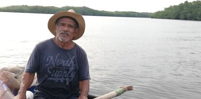
Santos López ventures into the waters of the Jiquilisco mangrove every day to guarantee his subsistence fishing.Julián Reingold
The afternoon is falling as the boat advances, and on the horizon the limits between the foliage of the mangroves and the mountain range formed by the Usulután, Tecapa and Chaparrastique volcanoes are blurred. On the boat, José María Argueta, executive director of Asociación Mangle, explains the enormous ecological importance of these ecosystems, since various species are raised in them - fish, birds, crocodiles, crabs, snakes, raccoons and the spider monkey. and they capture four times more carbon than any other terrestrial tree. In addition to protecting the animals, they also protect the population, since they function as living barriers against any hurricane or cyclone.
More than 13,000 fishermen develop artisanal subsistence fishing in this bay, who also supply the entire country and produce more than 60% of the shrimp consumed in El Salvador.
In this bay there is both subsistence artisanal fishing, carried out by more than 13,000 fishermen (who supply the entire country), and aquaculture processes, which produce more than 60% of the shrimp consumed in El Salvador.
An example of this are Santos and Miguel, who have been navigating the waters of Jiquilisco for three hours in their wooden boat and have barely been able to get about 20 pounds of fish — about nine kilos.
Since the price is very low, they say, the sale of it will hardly be enough to cover the purchase of tortillas.
Santos, 68 years old and five decades as a fisherman, says that there are days when the tide changes and they get absolutely nothing out of the water.
A couple of children from Punta Arenas Island pose from the top of a wooden ladder before the tide rises again.Julián Reingold
When the sea threatens to swallow your island
After skirting the islands of Rancho Viejo and Pirrayita - which suffered climate change with Hurricane Mitch in 1998, in addition to flooding and rising sea levels - we reach the third island called Punta Arenas. There we are greeted smilingly by Jimmy and Jefferson, two children who happily try to fish without a rod but with the lines between their fingers. From behind, Cándida Martínez, the grandmother of little Jefferson, appears, inviting you to climb the branches and tires until you enter her house, where seven people live. She, who was born on the island and has eight children, says that when the tide rises it goes overboard as well as from behind, and they are surrounded by water for up to four hours every day.
The gunwale and the levees they built with tires, mud and mangrove branches are not strong enough to contain the waves and there are days when they are surrounded for up to four hours
Rosa Martínez anguished explains that when the tide is strong, the sea washes and erodes everything that is on the coast.
The gunwale and the levees they built with tires, mud, and mangrove branches are not strong enough to hold back the waves.
The previous mayor helped them with tires, but nothing more, even though they need to build a containment perimeter to protect the 150 inhabitants of the island.
His mother, María Pilar Martínez, who arrived in Punta Arenas with her fisher husband 60 years ago, says that the island was bigger then, but the sea ate it up.
The mangrove that protects them has been caught by a termite plague more than a year ago, visible every time they go deep to look for shells, says Verónica De la Cruz, Martínez's cousin. In the forest you can see termites that are devouring the trees and threatening to eat up their houses, whose walls are made of branches and reeds. This also aggravates their supply of wood, since it is already prohibited to cut mangrove trees in the area.
When consulted in this regard, Xiomara Henríquez, biologist and manager of the Jiquilisco Bay Conservation Area by the Ministry of the Environment and Natural Resources (MARN), explains that termite mounds and ant hills are normal in mangroves, since organic matter attracts the insects and from the biological and ecological perspective there is no threat, since the mangrove wood, due to the crystallization of its own resins and the salt itself, is more resistant and becomes harder.
According to Henríquez, the main focus, from the perspective of climate change, is the protection of livelihoods, and taking into account that the place is a protected natural area, so there should be no houses there.
However, human settlements in the mangrove swamp exist and in the sector where the island is there is a lot of erosion because the flow of the water and the original routes of the two rivers - the Gran San Miguel de and the Lempa - have changed, causing a mismatch .
Dive among corals before the tide rises
To try to reach the protected natural area and Ramsar site complex of Los Cóbanos before the tide rises, you have to take the highway in the midday sun and walk through the alleys of the coastal town until you reach the beach. When we see the shore it is appreciated that the expedition to try to see the reef will not be easy, since the tide has just risen and the waves will push us against the rocks. The changes in the sea have caused the bleaching of the corals, especially the porites lobata species - the most representative of the area - showing pink spots and invasion of algae, which is a sign of deterioration in the health of the ecosystem.
Wilfredo López, a marine biologist, member of the NGO Territorios Vivos El Salvador, has studied the only marine grassland discovered to date —in Jiquilisco Bay— in addition to the colonies of a coral species known as
psammocora obtusangula
—in the shape of
little fingers.
- which is restricted to a single sector of the Los Cóbanos reef.
This hard coral species was documented in 2007 and since then approximately 67% has been affected by bleaching, although this year there was finally some recovery of coral patches.
Environmental factors are decisive in the recovery or not of a bleached coral: if it is very intense, they break, it is lost and it dies
Environmental factors - pollution, high temperature, too much exposure to the sun - are decisive in the recovery or not of a bleached coral: if it is very intense, they break, it is lost and it dies. Without coral reefs, some species of fish are left without shelter, and without food. From the NGO Territorios Vivos they explain that bleaching has been less frequent in colonies of the same species that are only found in a subtidal area.
But not everything is hopelessness. In front of the Los Cóbanos beach, whales converge —from November to March—, orcas, as well as visits from lions and sea elephants. Currently, the Megaptera project —supported by MARN— seeks to promote sustainable tourism in the coral area to promote development in the community through a responsible protocol for the sighting of marine fauna and the training of local guides. Whales are identifiable by their tails, which is why MARN has formed an alliance with the Happy Whale organization. One of the 55 whales that have visited El Salvador has been named La Cobaneña.
Despite pollution and climate change, both the reef and the mangroves still survive, and that is vital for migratory species and communities.
El Salvador's authorities still have time to achieve resilience and find a delicate balance between human settlements, coastal ecosystems and sustainable tourism, but they must hurry.
FUTURE PLANET can follow on
,
and
, and subscribe
here
to our 'newsletter'
.