
More than 520,000 hectares have been lost to fires in the US 4:35
(CNN) -
"Yes, it is summer, but this kind of heat can kill."
A stark reminder from the National Weather Service, as dangerous heat engulfs the east and west coasts through the start of the weekend, placing nearly half the country under heat alerts and potentially breaking record daily temperatures.
"The Pacific Northwest and Northeast can expect daily record highs to break on both Thursday and Friday, while even more locations have a better chance of observing record daily warm minimum temperatures," the Weather Prediction Center said.
Check the forecast where you live
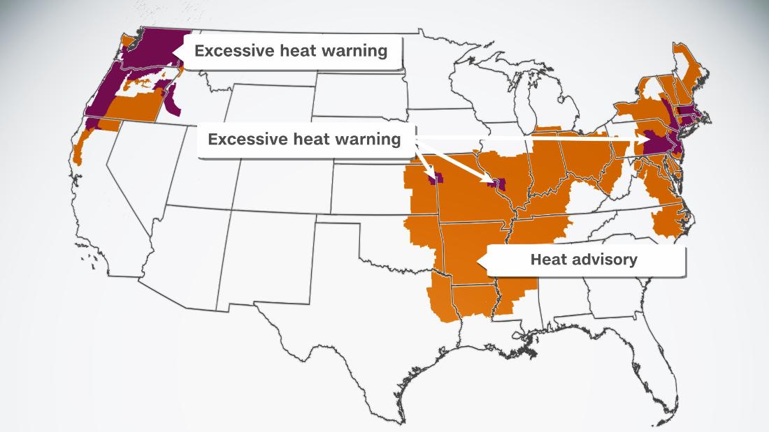
Nearly 58 million people are under excessive heat warnings, with major cities such as New York, Philadelphia, St. Louis, Kansas City, Seattle and Portland included in this highest-level alert.
"Today features numerous heat advisories and some excessive heat advisories from the central plains to the northeast. Heat indices in these areas will range from 37.8 to 43.3 ° C, with some locations as high as 46 degrees," he said the WPC.
advertising
Around 195 million Americans are under a watch / warning / advisory for dangerous heat.
Yes, it's summer, but this type of heat can kill.
Avoid strenuous activity during the midday, and bring along extra hydration, even if just going about normal business.
https://t.co/asAP0ZR0oK pic.twitter.com/v3NXefjLmy
- National Weather Service (@NWS) August 11, 2021
The Pacific Northwest faces another round of dry heat
The heat is on the entire west coast, concentrating on the Pacific Northwest once again.
Temperatures in the region are forecast to rise 6-12 ° C above average and hot, dry heat will persist into the start of the weekend.
The difficulties of facing a heat wave 0:53
"Thursday temperatures will even challenge some record daily highs in the Northeast and Pacific Northwest," the WPC said.
Seattle will be around 32 ° C on Thursday and Friday and Portland could even hit 38 ° C by the end of the week.
This will create especially dangerous conditions in a region where many do not have air conditioning.
It will be the second major heat wave in the Pacific Northwest this summer.
In June, the all-time record temperatures were surpassed when cities like Seattle soared to 42 ° C, while Portland baked under an oppressive and unprecedented 46.6 ° C.
During that period, hundreds of visits to the emergency room were reported for heat-related symptoms and deaths than usual.
Many may head to the water to seek relief from the heat, but in doing so, they could face new danger.
Scientists say this invisible gas could seal our fate in climate change
"Hot air does not always mean hot water in lakes, streams or oceans. Water at 13 ° C may not seem very cold, but it can be deadly. Diving in cold water of any temperature becomes dangerous if you are not prepared for it. Sudden exposure can affect your body and brain, "warns the NWS.
Body heat is lost 25 times faster in cold water and can quickly result in hypothermia.
In the coastal regions of the Pacific Northwest, where high temperatures are rare, many people flock to the shores.
Planning on heading to the water to cool down?
Cold water, even when it is so hot outside, can still kill.
Remember to grab your life jacket, if you go in the water swim with a buddy, & know the signs of hypothermia.
#ORwx #WAwx #PNWHeatWave pic.twitter.com/Nv4FpJF249
- NWS Portland (@NWSPortland) August 12, 2021
"High rates of beach visits occurred during the June heat wave and resulted in increased rescue and fatality rates," said the National Weather Service in Portland, Oregon.
Higher air temperatures increase the chance of getting a cold stroke when entering the water, which can cause muscles to stiffen and people to drown.
Seattle's record for the most consecutive days at 35 ° C or higher is four, and if this week's forecast holds, it will hit five.
Sweltering Northeast Temperatures
On the other coast, heat alerts span the northeast from North Carolina to Maine through the end of the week.
Highs of 32 ° C with relative humidity values launch heat indices above 38 ° C and bring sweaty, sweltering heat that could break daily records.
Excess heat warnings include major cities in Philadelphia, New York and Boston through Friday.
Actual temperatures in New York will be around 35 ° C and won't drop below 32 ° C until Saturday.
Washington could hit 38 ° C on Thursday and see no highs below 32 ° C until Sunday.
The extreme heat continues today with most of the region seeing maximum heat indices over 100. Stay cool!
#PAWX #NJWX #DEWX #MDWX pic.twitter.com/xP7EhWcDxI
- NWS Mount Holly (@NWS_MountHolly) August 12, 2021
"A multi-day stretch of oppressive to dangerous heat and humidity continues today, and is expected until at least Friday. Today will be the most dangerous in terms of heat and humidity with heat indices forecast as high as 43 ° C," he said the NWS in Boston on Thursday.
Humidity in the region will increase relative humidity values and make hot weather feel even hotter.
"The main concern tonight is the lack of relief from the heat. Parts of Philadelphia may not fall below 27 ° C," NWS Philadelphia said Thursday.
Persistent heat at night can be dangerous and deadly, increasing your chances of getting heat-related illnesses.
What to do to limit the effects of climate change?
Experts focus on the actions of governments
"This is a problem because these temperatures do not allow the body to cool down successfully overnight," said CNN meteorologist Allison Chinchar.
"The temperature must drop to at least 27 ° C for recovery to begin. In fact, a person can lose up to 2 liters of fluid overnight through sweat if the temperature does not drop below 29 ° C" added.
The coastal heat waves come after a summer hit by record temperatures.
They are not out of the ordinary, but the magnitude of recent events has climate scientists warning of what is to come.
Heat waves are getting hotter due to the climate crisis.
With 2 ° Celsius of global warming, the highest temperatures would reach almost 3 degrees Celsius (5 degrees Fahrenheit) higher than previous heat waves.
Scorching in the South and Midwest
The Mississippi River Valley will also face temperatures in excess of 33 ° C for the next several days.
The heat index will even be above 43 ° C in some places.
The heat index takes into account humidity and temperature, creating a "temperature sensation".
The human body produces sweat when heated to cool itself, moisture evaporates and cools the skin.
But when conditions are excessively humid, sweat has trouble evaporating and feels hotter.
Wildfire devastation in the US 0:56
St. Louis and Kansas City are included in the excessive heat warnings Thursday as their heat index values rose to 38 ° C.
Nearby Midwest regions have heat advisories, where the urban heat island effect is less intrusive.
Neighborhoods with little tree cover, few grassy areas, and a lot of concrete can be 6 to 9 degrees hotter than surrounding areas.
Kansas City will see "dangerously hot conditions with heat index values up to 43 ° C," according to the National Weather Service.
Nighttime lows are forecast to remain at 27 ° C, giving little relief from the relentless heat.
Heat heat wave