
CNN reporter interrupted live connection by Grace 0:54
(CNN) -
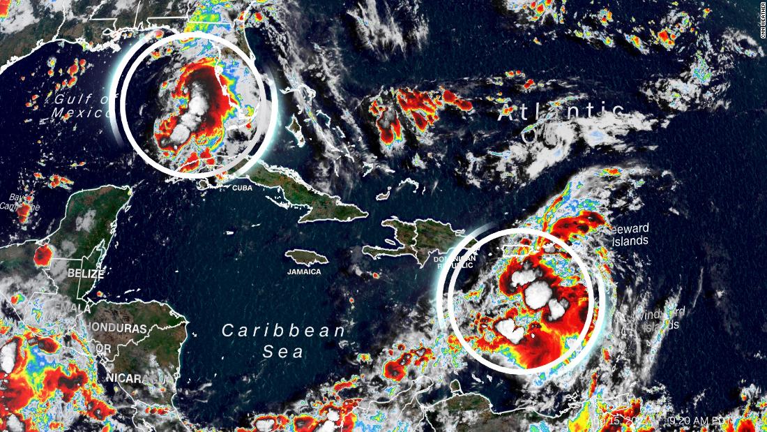
Tropical Storm Fred steadily strengthens as it moves toward the Florida Panhandle.
Meanwhile, Tropical Depression Grace is moving toward Haiti, which could affect recovery efforts after a major 7.2-magnitude earthquake that struck the country on Saturday.
Additionally, the eighth tropical depression of the season formed northeast of Bermuda, according to the 11 p.m. EDT update from the National Hurricane Center.
A tropical storm watch has been issued for Bermuda and nearby waters.
On Sunday morning, Fred regained tropical storm status over the Gulf of Mexico, according to reports from an Air Force Reserve Hurricane Hunter aircraft.
The storm had sustained winds of 72 km / h and was 330 km west-southwest of Tampa, Florida, on Sunday night.
A tropical storm warning has been issued for the Florida Panhandle from Navarre to the Wakulla-Jefferson County line prior to Tropical Storm Fred.
An alert remains in effect for the Florida Panhandle coast from the Alabama-Florida border to Navarre, along with inland areas of southern Alabama.
On the forecast track, Fred's center should move across the eastern and northern Gulf of Mexico and then make landfall in the Florida Panhandle, just west of Panama City, Monday afternoon with 96km / h winds. .
More than 720 people died after the earthquake in Haiti;
Rescue efforts continue as tropical storm Grace approaches
A storm surge warning was also issued for the Florida Panhandle coast from Indian Pass to Steinhatchee River.
A storm surge warning means there is a danger of life-threatening flooding from increased water moving inland from shore over the next 36 hours.
advertising
Storm surge is forecast to be highest from Indian Pass to the Steinhatchee River in Florida, where 1-1.5 meters are expected.
A 30 cm to 1 meter storm surge is forecast Monday from the Alabama-Florida border to Indian Pass, including Pensacola, Choctawhatchee and Saint Andrew Bays.
Fred will also bring rain and wind gusts to other areas of the Southeast, including Alabama, Georgia and the Carolinas in the early part of next week.
Rain throughout the southeast will increase as Fred interacts with a frontal system.
Widespread total rainfall of 7 to 15 centimeters is forecast across the southeast, with isolated totals of up to 23 centimeters possible through Tuesday.
Fred on Sunday caused the closure of schools throughout the Florida Panhandle.
Schools in Bay County, Okaloosa County, Walton County and Santa Rosa County announced that all classes were canceled Monday, as were after-school activities.
Classes are expected to resume Tuesday, according to postings on each school district's website.
Tropical depression Grace will hit Haiti
Grace weakened from a storm to a tropical depression on Sunday, with maximum sustained winds of 56 km / h.
The current forecast from the National Hurricane Center has Grace traveling through the Greater Antilles, hitting the Dominican Republic and Haiti on Monday and Tuesday, with expected wind speeds of 64 to 80 km / h.
The center of the storm may pass just north of where the earthquake struck Haiti, but there will still be impacts that can hamper relief and rescue efforts.
Gusty winds and heavy rains are the main threats associated with this storm for Haiti.
Helping Victims of the Haiti Earthquake
A tropical storm warning for Grace has been suspended for Puerto Rico, the Virgin Islands and parts of the Dominican Republic, the National Hurricane Center said in its latest advisory, and the government changed the advisory to an advisory, the NHC said.
A tropical storm watch means that storm conditions with winds of 62 to 120 km / h are possible within 48 hours of issuance, and a warning means such conditions are expected for affected areas.
Grace is forecast to bring 3 to 6 inches of rain to Puerto Rico and parts of the Leeward Islands.
Isolated totals of up to 20 centimeters are possible throughout Puerto Rico, which could lead to flash floods and landslides.
For Haiti and the Dominican Republic, widespread rains of 10 to 18 centimeters are forecast, with isolated amounts of up to 38 centimeters that could also lead to flash floods and landslides on Monday and Tuesday.
Grace's intensity and trail after passing the island of Hispaniola remains uncertain at this time.
The NHC track currently has the storm tracking south Florida and the Gulf of Mexico by the end of the week.
CNN's Tyler Mauldin, Jackson Dill, and Gene Norman contributed to this report.
Tropical storm