
This is the ravages caused by Ida in Louisiana 1:06
(CNN) -
As millions try to recover after Hurricane Ida ravaged the eastern United States from the Gulf Coast to the Northeast, meteorologists are on the lookout for Hurricane Larry in the Atlantic.
At the same time that Ida was creating her 1,500-mile-long path of destruction, Tropical Storm Julian and Tropical Storm Kate formed and dissipated in the last week.
But now Hurricane Larry is churning in the central Atlantic.
Satellite images show before and after the destructive passage of Hurricane Ida in Louisiana
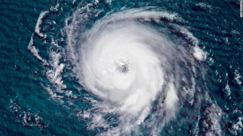
On Friday night, Larry intensified to a Category 3 hurricane with maximum sustained winds of 185 km / h, according to the National Hurricane Center (NHC).
Winds from the storm were up to 120 km / h according to the NHC update on Saturday at 11 a.m. (Miami time).
That makes Larry the third major hurricane - Category 3 or higher - in the Atlantic basin this season.
Larry could reach Category 4 strength with maximum winds of 225 km / h over the weekend.
Climate change is making hurricanes stronger, slower and wetter;
Ida was an example of this
Larry, moving north and west over the open Atlantic, will not be a direct threat, at least for the next few days.
advertising
As of Saturday morning, the storm was located in the eastern Atlantic Ocean about 1,697 kilometers east of the Leeward Islands.
Larry should gradually turn northwest after Labor Day (Monday), and the storm could approach Bermuda, still like a major hurricane, by Thursday, although the forecast track is so far away that it is uncertain.
Larry is not expected to pose a direct threat to the United States, but he could cause big waves and dangerous currents along the East Coast by the end of next week.
"A significant swell is likely to hit the east coast of the United States after Labor Day. This swell is likely to cause swell that can be life-threatening and affect current conditions," the hurricane center said.
The hurricane center also warns that "the surge generated by Larry is expected to reach the Lesser Antilles on Sunday."
The center adds that the swell is likely to cause life-threatening swell and affect current conditions.
Long-range forecasting models show that Larry continues into Bermuda and will pass east of the island sometime in mid to late next week.
There is growing disagreement in models about how close the storm will approach Bermuda.
Drones show the destruction left by Hurricane Ida 1:02
CNN's Jackson Dill contributed to this report.