
Hong Kong may be hit by two tropical cyclones this weekend.
According to the observatory's path probability forecast, the path of the super typhoon "Sundu" will be adjusted to the west, passing through the Bashi Strait into the South China Sea, and the probability of rushing towards Hong Kong has increased to 30%.
The former assistant director of the observatory, Liang Rongwu, explained that severe tropical storms Consen and Chandu may have the "Fujiwara effect". The paths of the two will get closer and closer, but I believe the effect is not very obvious.
He said that the key to dominating the path of super typhoon Chanthu is the ridge of subtropical high pressure. If the "subtropical high" is stronger, Chanthu will move westward, that is, closer to Hong Kong.
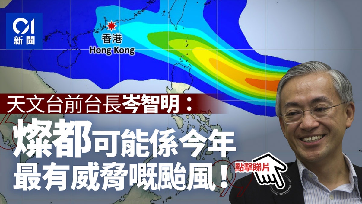
The director of the Observatory's front desk, Cham Chi-ming, pointed out on Facebook that although "Chanson comes first," he believes that it is necessary to pay close attention to Chandu, describing that "Chandu may be the most threatening typhoon this year."
+13
According to the latest tropical cyclone path forecasts updated by the Observatory this year, the super typhoon Chanthu will roughly move to Taiwan and the Luzon Strait in the next two or three days. After entering the South China Sea, it will weaken into a strong typhoon on Sunday (12th). Later, it landed in Xiamen City.
However, the observatory's path probability forecast shows that the chance of Sundo moving towards Hong Kong has increased to 30%.
Former director of the observatory, Cen Zhiming, explained on Facebook that probabilistic forecasts are based on one or several model integrated forecasts, and there are still other data that will affect the forecast path.
Conson is expected to enter and traverse the South China Sea in the next few days, moving roughly towards Hainan Island.
With reference to the European Center for Medium-Range Weather Forecast (ECMWF), Sundo will make landfall in southern Taiwan on Sunday; the US Global Forecast System (GFS) predicts that Sundo will enter the South China Sea on Saturday (11th), and next Monday (13th) It landed in the area of Shanwei City, Guangdong Province, that is, to the east of Hong Kong, very close.
Observatory: Sundo enters the South China Sea or "Fujiwara Effect" appears with Conson
In response to the inquiry, the Observatory pointed out that after Sandu and Conson entered the northeastern part of the South China Sea, there was a "Fujiwara effect" with Kang Sen, and that they would pull each other when they approached.
At present, the path and intensity of Sundo are uncertain, but for the time being, the observatory expects Sundo to move roughly to Taiwan and the Luzon Strait.
Liang Rongwu said that the "Fujiwara effect" would in principle cause Chandura to move to the west, that is, towards Hong Kong, but the forecast chart shows that the "Fujiwara effect" is not very obvious.
On the contrary, the subtropical ridge of high pressure is actually the key to the movement of Sundo.
Liang explained that the current strong subtropical high has caused Chandu and Conson to move to the west. However, the observatory predicts that the subtropical high will weaken in three days, and there is a chance that the two tropical cyclones will move northward, that is, Chandu will deviate from Hong Kong.
▼ECMWF predicts the movement paths of two tropical cyclones▼
▼GFS predicts the moving paths of two tropical cyclones▼
Chandu rises to level 4 in a row into a super typhoon in less than a day
In addition, Chandu escalated category 4 to a super typhoon in less than a day. Liang Rongwu pointed out that there are many reasons for the intensification of tropical cyclones, including hot sea temperature, weak vertical wind shear, and high-altitude divergence, such as "exhaust fan". "The tropical cyclone's airflow is pumped to the top to increase the updraft.
The Observatory expects the highest continuous wind speed near the center of Chanthu tomorrow (9th) to reach 220 kilometers per hour. With reference to the tropical cyclones that affected Hong Kong in the past, which caused the No. 10 typhoon, the super typhoon "Mangkhut" that hit Hong Kong in 2018 had the highest wind speed. It reached 250 kilometers per hour; the second was the super typhoon "Hobe" in 1979 with a central wind of 240 kilometers per hour; the third was the super typhoon "Aisi" in 1975 with a central wind of 220 kilometers per hour .
Liang Rongwu, former assistant director of the observatory.
(Profile picture)
▼7.19 Tropical Storm Chapaka hits Shek O, there are still citizens swimming ▼
+8
Double typhoon | Conson approaches the Observatory and considers issuing Typhoon No. 1 to Sundo to upgrade the super typhoon. Double typhoon | Conson and Sundo tropical cyclones will attack the observatory from the left and right side to the observatory will be a very hot 34 degrees double typhoon in the coming two days | Conson, Sundo tropical The storm hits 800 kilometers of Hong Kong and was successful over the weekend?
Double typhoon | Tropical storm Conson approaching 500 kilometers of Hong Kong on Saturday, the observatory expects squally thunderstorms on Sunday, double typhoon | 2 tropical depression generation observatory expects one to move into the South China Sea, wind intensifies on weekends
01News