
MORE INFORMATION
In the new guide 'En route through Navarra'
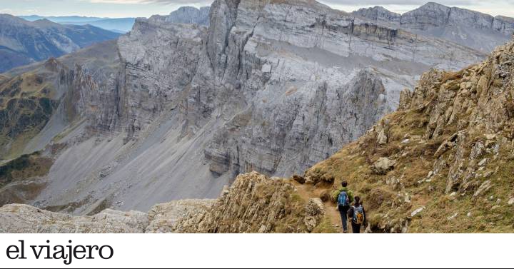
The valleys of the Navarrese Pyrenees are a true paradise for hikers.
But not only the high mountains lend themselves to more or less demanding walks.
Faced with the undoubted attraction of the northern peaks, the Ribera Navarra, in the south of the province, offers alternative routes to discover on foot
medieval towns
and
Baroque villas
crossed for centuries by the
Camino de Santiago.
In addition to the Trans-Pyrenees, which completely crosses the Pyrenean mountain range, there are other very interesting paths, such as the
Bidasoa Smugglers' Path
, with a total of 176 kilometers divided into seven stages, which crosses the border with France;
the
Blue Potoka route
or Xareta trail (35 kilometers), which from Zugarramurdi explores the
Xareta valley
;
or the
Camino Real,
a 37-kilometer path, with three possible detours, that starts from the Foz de Burgui and goes up the Roncal valley to Isaba.
A tunnel goes deep into the guts of the mountain at the Foz de Lumbier.
Oleksandr Korzhenko alamy
Through the gorges of Lumbier and Arbayún
The Lumbier is one of the most spectacular routes in the shadow of the high Pyrenean peaks. Lumbier, in eastern Navarre, about 40 kilometers from Pamplona, is a delightful town embraced by the Salazar and Irati rivers. It also boasts
the oldest town hall in Navarra, a Renaissance church and a monastery
, that of Santa María Magdalena, which was previously occupied by Benedictines but is now a cultural center. But the jewel of the municipality is
the Foz de Lumbier
: a cleft in the mountain through which the Irati River makes its way and in which
the largest colony of vultures
lives.
of Navarra. They are seen hovering overhead and nest in the dizzying rock faces. The gorge, drilled over millions of years, is so narrow that at some points the walls, up to 400 meters high, seem to touch. From the road that connects Pamplona with the town of Jaca (Huesca) there is a good panoramic view of its southern end, but if you want to visit the best thing is to go to Lumbier, and find out about the two signposted trails that run through the gorge.
And if that sickle (or gorge) knows little, on the way to the town of Navascués we find another:
the Foz de Arbayún
, six kilometers long and walls more than 360 meters high, which makes it one of the most imposing of the provincial community. Unlike the one in Lumbier, which can be traversed along a path that runs alongside the Irati river, this one, dug by the Salazar river,
can only be seen from the top of a viewpoint
. To get there and also enjoy the nature that surrounds it, you have to follow a path that starts shortly after Domeño, in the port of Iso: once you arrive at the place, the spectacle is impressive.
And since we are in the area, it is almost obligatory to go to
Navascués
, which in addition to some beautiful traditional houses has an unexpected
Gothic church
and, above all, its great treasure: the
hermitage of Santa María del Campo
, from the 12th century, one of the most beautiful samples of
the rural Romanesque of Navarra
.
The Foz de Lumbier is an impressive canyon around the Irati River, a protected natural area where kayaking is also practiced.
Cro Magnon alamy
Roncal Valley, a route with the aroma of good cheese
The town of Burgui
is the gateway to
the Roncal Valley
(Erronkari, in Basque), an exceptional natural environment, to the northeast of the community, in the Pyrenees mountain range, arranged from north to south and crossed by the Esca river.
Made up of seven municipalities (Burgui, Garde, Isaba, Roncal, Urzainqui, Uztarroz and Vidángoz), this is one of the most typically Pyrenean regions.
Many mountaineers come here, attracted by the perfume of its famous cheeses and also by the possibility of crowning the westernmost peaks of the Pyrenean mountain range.
It takes a good effort to overcome the more than 1,000 meters of unevenness that lead to the
summit of Txamantxoia
(1,941 meters), a training for more difficult mountains.
The views from the top are majestic.
Isaba
is the busiest point in the area, at the confluence of the Belagua and Belabarce valleys. Not only is it an ideal destination for hikers looking to fill up on mountains, it also has an interesting cultural and architectural heritage. A path leads to
the Belabarce waterfall
, a waterfall formed by the homonymous stream that ends in a natural pool. In the center of the valley,
Roncal
is a quiet and peaceful village to make a stop.
The famous tenor Julián Gayarre was
born here in 1844
, and they boast about it in the town, with a mausoleum by the sculptor Mariano Benlliure, considered the last great master of nineteenth-century realism, and a museum in his birthplace.
View of the Roman bridge and the Irati river, as it passes through the Navarran town of Burgui.
Asunción Idoate Iribarren getty images
Before ending the excursion, gastronomy lovers should visit a cheese factory, where the renowned Roncal cheese is produced, made from raw latxa sheep's milk.
The area of production and maturation of this cheese is exclusive to the seven municipalities of the valley.
One of the best places to try it is
Borda Marengo
.
The southernmost town in the valley is
Burgui, a
destination for travelers heading to the heart of the Navarrese Pyrenees, built around the beautiful church of San Pedro. In addition, it has a beautiful medieval Roman-style bridge. Under one of its four arches, every year, at the beginning of May, the rafts descend by the river Esca. The Day of the Almadia has become a symbol of identity of this town, which remembers how with these peculiar boats the forest masses of the Pyrenean mountains were given out.
If you are traveling with children, before following the route, it is a good idea to take the four-kilometer path that from the town reaches the
Foz de Burgui
, a deep canyon dug by the river Esca, and that crosses the so-called
Town of the Trades
, an initiative launched in 2003 with reconstructions of workshops of yesteryear: sawmill, stonemason, baker, coalman, and so on.
A beautiful interpretive tour through the ancient ways of life and work of the Pyrenean villages and valleys.
One of the largest vulture colonies in Europe, along with numerous rock birds, nests on the cliffs of the Foz de Burgui.
A family ascends the top of the Table of the Three Kings, which with a height of 2,442 meters is the roof of Navarra.
Tolo Balaguer alamy
Valle de Belagua, Pyrenees in its purest form
On the border with Huesca and France, in the municipality of Isaba, the Pyrenean nature is shown in its purest form
.
The Belagua Valley is a dreamlike place
, one of those to be seen and not forgotten.
A small glacial valley that in turn serves as the head of the Roncal valley
.
It extends to the north of Isaba, crossed by the homonymous river, and is one of the most important and panoramic natural places in Navarra.
Located between 1,100 meters from
Rincón de Belagua
and 2,442
meters from
Mesa de los Tres Reyes,
and also dominated by the stark
peak of Añelarra
(2,349 meters), at its head is the
natural reserve of Larra-Belagua
, the karst plateau largest in Europe (120 square kilometers). Dotted by black pines and with wide clearings destined for pasture, in thousands of years this immense mass of tender limestone rock has become a sieve formed by very deep chasms, such as that of the
Piedra de San Martín
, 1,410 meters deep. If you want to go up here and see the dozens of species of birds that live in the area (chamois, marmots and other small mammals have found their habitat among these strange formations), the best thing is to go to
the Belagua Refuge
, recently reopened and which offers bar, restaurant and accommodation service. Dozens of trails that enter the area also start from it.
The Table of the Three Kings
is the
roof of Navarre
and marks the boundary between Spain and France, and also between the foral community and the province of Huesca. With its
2,442 meters of altitude
, it offers impressive views and is a destination desired by all hikers and lovers of great panoramas. The suggestive name is due to the fact that formerly at its summit the borders of the kingdom of Navarre, Aragon and the Viscounty of Béarn converged. In this way, the three kings could sit and talk each without leaving their land.
If we have time and good training, the climb to the top, with an unmistakable pyramidal shape, is one of the essential excursions. Most of the mountaineers prefer to reach the summit starting the route in the
Linza refuge,
in the Ansó valley, already in Aragonese territory. It is a relatively short and easy ascent (16.2 kilometers round trip; eight hours in duration), with a difference in altitude of more than 1,100 meters (from the 1,340 meters of altitude of the refuge), and is within reach of the fans in good physical shape.
However, there is another possibility that especially attracts the most
purists of the mountain
and that runs entirely in Navarre territory. This is the itinerary that begins in the
Rincón de Belagua
(22 kilometers round trip; around 12 or 14 hours to complete it), crosses the Larra nature reserve, crosses the
Solana basin
and finally connects with the
Linza road
to the top. Due to the difficulty of the route and the presence of snow during the autumn, winter and spring months, it is advisable to face the road only in summer. You have to carry a good supply of water (there are no fountains along the trail) and everything you need to protect yourself from the cold and rain.
A young woman observes the landscape from the top of the Aiako Harria mountain.
Unaihuiziphotography getty images
The route of the smugglers of the Bidasoa
Illegal smuggling of goods or people has been traditional at almost all borders.
This has also been the case in the
Bidasoa valley
, at the mouth of the river that acts as the natural border between Spain and France.
For centuries this valley and its intricate mountain trails became an ideal place to hide these activities.
Today,
the
Bidasoa Smugglers' Path
(Kontrabandisten Bidea, in Basque) is a
176-kilometer
circular journey
that is usually done in seven stages
starting from
Hendaye
, in the French Basque Country. It goes through mountain trails that were of great importance for smuggling, especially in the mid-twentieth century. The route, marked with accommodation in small towns or near natural enclaves, passes through some very interesting protected areas in Gipuzkoa and Navarra, such as the
Txingudi wetlands
, the
Aiako Harria natural park
, the
Artikutza mountains
, the
Leurtza natural area.
, the
SCI of Belate
or the
peat bog of Larrun
. Walking along this path we will also find remains of human presence since prehistoric times in the form of megaliths, Roman remains (mining) and traces of the Middle Ages in hamlets and palaces.
Autumn in the Urbasa y Andía natural park.
getty images
Urbasa and Andía natural park: the source of the Urederra river
The plateau that separates the Atlantic and Mediterranean territories of Navarra is an enchanted territory of lush forests, where its porous rocks allow the outcrop of prodigious rivers such as the Urederra, which gives rise to one of the kindest walks in this protected natural area, with
pools and waterfalls that are a feast for the eyes
and wildlife.
The route can start in the
Urbasa y Andía natural park
, passing through some of the most unknown towns in the foral community.
We can start in
Zudaire
, to the south, capital of the municipality of
Améscoa Baja
, formed by seven towns settled in the valley at the foot of the
Urbasa mountain range
.
Although it has some artistic landmarks, such as the church of San Andrés (from the 13th century), the area is attractive above all for its exuberant nature.
Essential for hiking enthusiasts is the
source of the river Urederra
, which is accessed from different paths.
The busiest is the one that begins in
Baquedano,
But if you want to enjoy the journey in almost total solitude, it is preferable to start the road to these small waterfalls in Zudaire itself.
The circular route is 13 kilometers long and is suitable for all types of walkers.
But hikers come here to explore the extensive Urbasa y Andía natural park, which encompasses the Urbasa and Andía mountain ranges, one of the most interesting protected areas in the community. Formed by
dense forests of beech, maple, ash and oak,
which cover what was once the bed of a great prehistoric ocean, it is home to more than
30 species of mammals and a large number of reptiles
, and hundreds of trails cross it. The reserve has limited access to 500 people per day, so it is advisable to book in advance.
Across the park to the north is
Urdiain
, another base for many excursions around the park.
This small town has a certain monumental air, due to its many emblazoned houses in the historic center and the baroque splendor of its parish church.
Autumn landscape in the Irati Forest, in the Navarrese Pyrenees.
LUNAMARINA getty images
The spectacular Irati Forest
The Irati Forest is one of the biggest tourist attractions in Navarra. It is an
impressive beech forest in the heart of the Pyrenees
, with almost 17,000 hectares, watered by the homonymous river that every year attracts a multitude of hikers and nature lovers. Its lush forests even cross the Pyrenean border and extend to the French side. In this immense territory of
beech and fir trees
- the second largest in Europe - and other evergreen trees, it will not be uncommon to find
roe deer, deer or salamanders
. The route that makes a complete loop is long (21 kilometers) and with continuous elevation changes, some abrupt, but the scenic reward is worth the effort.
La Selva has only two access areas: the main one is in
Ochagavía
and the other, in
Orbaizeta
, in the shadow
of the Ori peak
and the
Abodi mountain range
. If you are traveling with children, or you want to know the area in depth before entering the forest, it is a good idea to go to the first of the two, which has a reception center, an information point and a room in the Casas de Irati of exhibitions. From there, in addition, countless routes start both to do on foot and by mountain bike (with almost 400 kilometers of route), ideal for all physical levels. Among the most appreciated are those that go to
the Irabia reservoir,
a placid mirror of water formed by the Irati River; to
Cubo waterfall
and the so-called
Errekaidorra trail,
a relaxing themed walk that allows you to discover the different uses of forest resources. If it is accessed through Orbaizeta, there is an information point in Arrazola.
At the top of the Irati valley, in
Orbaizeta
, there are a large number of rural houses and other accommodation, although there is nothing of special interest. A little further, it is worth making a stop in
Ochagavía
, which is reputed to be the most beautiful in the Navarrese Pyrenees. It is a small town with cobbled streets and elegant ashlar palaces, crossed by the
Zatoya and Anduña rivers
, with a large number of picturesque bridges. Despite the fact that its old town houses beautiful palaces, the main attraction is about six kilometers from the town. It is the
hermitage of Our Lady of Muskilda,
the place of worship most revered by the inhabitants of the valley, on the top of the mountain of the same name, located at 1,225 meters of altitude.
From the park that surrounds the complex, you can enjoy impressive panoramic views of the surroundings, with the
Ori peak
as a backdrop to the Irati Forest.
Inside the Zugarramurdi caves, a meeting place for witches during the Middle Ages in Navarra.
DAVID HERRAEZ alamy
Myths and legends in Zugarramurdi
Mystery and witchcraft lovers love some Pyrenean villages where myth and reality intertwine, resulting in immortal legends. The most famous of all is
Zugarramurdi
, in the Baztan region, where it is said that many witches and sorcerers lived for centuries and that it has ended up turning its history into a tourist attraction. It is said that, from the Middle Ages, in Roncal, in Roncesvalles and in the villages scattered throughout the
Salazar valley,
some men and women gathered at night in isolated places to worship the devil.
Against these manifestations (real or supposed) both the kings and the Holy Inquisition fought throughout the centuries: the former empowered the mayors to prosecute the presumed participants in these meetings;
the second, which intervened in more than 60 Navarrese towns in 1610, held a trial that ended the lives of a dozen of them, sent to die at the stake.
In addition to visiting the
Museum of the Witches
, the most curious visitors can take
four thematic routes
that touch the most emblematic places of this phenomenon: the brochures with the itineraries are available in all the tourist offices in the area.
The Zugarramurdi caves
have the charm of the weight of history. We can go through the main cavity - with a stream that accompanies it - and then face the ascent to a simple summit but with a very good panoramic view,
Peña Plata
(Atxuria, in Basque). It is a route of just over 10 kilometers with 600 meters of unevenness, but it is easily done due to the progressive changes in elevation.
From Zugarramurdi, it is worth going through the forest to the
village of Urdax
(just four kilometers away), spread out around an ancient monastery.
It is a good idea to visit its beautiful
monastery
, considered the most important in the region.
Founded around the year 1000 as a hospital for pilgrims heading to Santiago de Compostela, it was rebuilt in the middle of the 16th century after a fire, when, in addition to the church, the cloister and the monks' rooms were also built.
Today, after several decades of neglect, the temple is open to worship, while the other rooms have been converted into an interesting museum.
The desert landscape of the Bardenas Reales, in Navarra.
ADDICTIVE STOCK CREATIVES alamy
The surprising landscapes of the Bardenas Reales
Not far from the green valleys of the Navarrese Pyrenees we come across an arid surprise in the form of a desert of 415 square kilometers, populated by a special flora and fauna. The desert lands of the Bardenas Reales are one of the most unexpected places in the green Ribera Navarra, a set of landscapes without any vegetation, dotted with geological vagaries modeled by erosion, such as the so-called
fairy chimneys,
which for a moment make to think that we are in Cappadocia (Turkey). Like the spectacular
Cabezo de Castildetierra
, which is probably the soul of the park and appears in thousands of photos on Instagram. To get to know the area, it will be necessary to make use of the traditional paths, those that transhumant shepherds have used for centuries.
The Bardenas Reales are on the border with Aragon and bear the title of
Unesco biosphere reserve.
They can be accessed for example by
Corella
, known as the Baroque capital of Navarra, with some of the most striking buildings in the region: palatial houses, monasteries, churches and a heritage that speaks of the importance that the riverside city.
Without going too far, the excursion can be completed with a visit to the towns of
Gallipienzo, Ujué and the Olite castle
, which will surprise more than one.
Another complementary experience is to sleep in some extraordinary accommodation that the Bardenas boast of, such as one of the
Valtierra cave houses
, excavated 150 years ago and converted into apartments;
or one of the best capsule hotels in Europe, the
Hotel Aire de Bardenas
, which offers the unique experience of sleeping inside a capsule with a transparent roof from which to observe the constellations.
The church of Barásoain, in the Valdorba region.
MELBA PHOTO AGENCY alamy
Truffles, Romanesque art and walks through Valdorba
Practically located in the geographical center of Navarra,
Valdorba
is a peaceful valley famous among
mushroom pickers and lovers of Romanesque art
(we are on a branch of the road to Santiago). Its territory also provides some
extraordinary truffles
. Hikers can take advantage of this peaceful corner to the south of Pamplona to visit the
millenary oak of Echagüe
and take a walk through pastoral fields in a 13-kilometer loop with only 300 meters of total elevation gain, which begins at the
Mairaga reservoir
.
This quiet valley is a transition between the Pyrenean landscapes of Navarra and the so-called middle zone, a mosaic in which varied forms of vegetation succeed and alternate:
grasslands and scrub, arboreal masses of beech, holm oak and gall oak, and terraced vine crops , almond, olive and cereal
. La Valdorba is made up of a score of small towns and hamlets grouped in municipal terms: Barásoain, Garínoain, Leoz, Olóriz, Orísoain, Pueyo and Unzué.
From the Peña de Unzué, from the Iratxeta path or from any viewpoint or promontory in the area, you can enjoy a unique panoramic view, with vegetation that draws a curious
chromatic
patchwork
. The Valdorba mountains are also home to one of the highest densities of birds of prey in Europe. On its smooth orography it is not difficult to distinguish
booted and short-toed eagles and red and black kites
. But we also find vultures and calandrias and, occasionally, some pair of goshawks, hawks, alcotán and Egyptian vultures. On the other hand,
wild boars, martens, foxes and badgers
inhabit the dense forest
. In addition to its natural wealth, this peaceful valley is dotted with small Romanesque jewels, such as the
church of San Martín
in Orísoain with a beautiful crypt, the hermitages of San Pedro de Echano in Olóriz or the hórreo or the
church of Asunción de Olleta
.
Panoramic view of Elizondo, a Navarran town crossed by the Bidasoa river.
ondacaracola photography getty images
Literary walks through the Baztan valley
The Baztan became fashionable with the famous trilogy by
Dolores Redondo
, a mystery novel that takes place entirely in this idyllic valley, surely the one that best represents the essence of the Navarrese Pyrenees.
There are even organized routes that follow the scenes of the books, and take us through the legend, literature and the realization of the area.
The villages of the Batzan are made up of orderly and sturdy whitewashed houses, cows and horses graze in their meadows and the lush forests result in a
bucolic rural landscape
, where many agricultural and livestock traditions survive. Starting from its charming capital,
Elizondo
, we can make a circular journey of 12 kilometers that reveals some of its best places.
We will stop for example in
Arizkun
, on the same river, and divided into different neighborhoods that stretch between forests and meadows.
In its old town stands the surprising
monastery of Nuestra Señora de los Ángeles
, which was ordered to be built in 1736 by Juan Bautista de Iturralde, a native of the valley who had made his fortune in Madrid.
Inside its church, which opens behind a splendid Baroque façade, there are five altarpieces dedicated to as many saints.
In case you find it closed, and before dedicating yourself to exploring the many natural landscapes of the valley, it is essential to visit the curious
neighborhood of Bozate
to discover the history of
the exhausts,
a population of uncertain origin that moved here around the 13th century.
But the capital of Batzan is
Elizondo
, its most representative town.
In the center, with an urban framework of medieval design crossed by the Bidasoa, an unexpected number of
stately homes and noble palaces
rise up
, mostly Baroque, a vestige of its prosperous past.
Among others, there are the
Arizkunenea palace
, from 1730, and the town hall, which since the 17th century overlooks the busy
Plaza de los Fueros
, where almost all of the best bars and restaurants in the city are concentrated.
The portico of the Church of the Holy Sepulcher, in Estella-Lizarra.
Marc Hill alamy
The route of all routes: the Camino de Santiago
The main route for walkers in Navarra is
the Camino de Santiago
, which it shares with all the communities in the north of the Peninsula. Up to four different itineraries of the Camino de Santiago pass through Navarra:
two branches of the Camino Frances, the Camino del Baztan and the Camino del Ebro
. The star route, without a doubt, is the one known as the French Way, the one that enters Navarra through Luzaide / Valcarlos, and that passes through such emblematic places as Roncesvalles, Pamplona or Puente la Reina. The road will discover a landscape that is transforming from the green Pyrenean valleys to the Pamplona Basin in a comfortable descent. From here we will find low-rise mountains that alternate with extensive fields covered by cereal or vineyards.
In
Roncesvalles
, the meeting and departure point for pilgrims, you must not only visit the impressive
Royal Collegiate Church
, but also other interesting places such as the
Charlemagne Silo
, probably the oldest building in the religious complex, built as a burial place for the Frankish knights who they died in the battle of Roncesvalles (August 15, 778 AD).
Other landmarks on this French Way through Navarra are
Estella-Lizarra
, probably one of the most beautiful medieval towns in the community, full of interesting churches, museums and monuments, such as the original
Carlism Museum
.
And, of course,
Puente la Reina
, which together with Estella, Los Arcos or Viana, are part of the original
Compostela path
.
The unique
octagonal
church of Santa María de Eunate
dates back to this period
, founded in the 12th century by Knights Templar.
Find inspiration for your next trips on our Facebook and Twitter and Instragram or subscribe here to the El Viajero Newsletter.