
Ships seek to study hurricanes from the inside 2:13
(CNN) -
This Friday is the statistical peak of the hurricane season, however, a monster named Larry is forecast to transform into a winter storm that will bring inches of snow to Greenland.
Yes, you read that right.
A hurricane that produces inches of snow.
It has been a crazy year for tropical systems, so why not?
This year is already ahead in terms of storms: 13 have already been named.
On average, we don't see 13 named storms until the end of the hurricane season.
Climate change is making hurricanes stronger, slower and wetter;
Ida was an example of this
Hurricane force winds are not uncommon in Greenland, but heavy snow hurricanes are.
Ships seek to study hurricanes from the inside 2:13
Centimeters of snow for Greenland
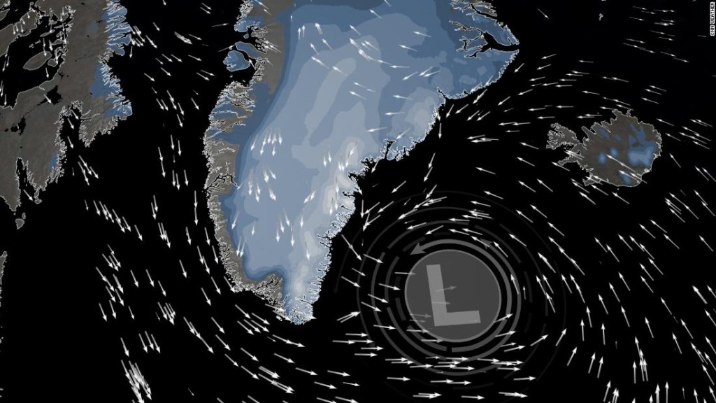
Hurricane Larry is forecast to slide off the east coast of Greenland this weekend.
When you get there, you will have sustained winds of around 96 km / h, with gusts of up to 136 km / h.
Larry's hurricane wind will likely produce blizzard conditions in Greenland, although Larry could lose the tropical aspects of a hurricane by then.
advertising
"Last Warning": US Government and Lawmakers Sound Climate Change Alarm Following UN Report
"Larry should become an extratropical cyclone on Saturday, and is now forecast to be absorbed by a larger extratropical low near Greenland by the end of the weekend," says the National Hurricane Center.
The term extratropical has to do with the core of the storm.
A hurricane has a warm core, while an extratropical (or posttropical) has a cold core.
Cold-core systems produce meteorological characteristics such as cold fronts and warm fronts, terms that people are most familiar with.
Warm-core systems produce meteorological features such as eyes, eye walls, and outer bands.
Here's what to know about the 2021 Atlantic hurricane season
As Larry interacts with this other system, it will be able to absorb an enormous amount of moisture, causing significant snowfall in Greenland.
Widespread totals of 12 to 18 inches are expected in the eastern half of the island nation.
The highest elevations along the east coast could reach 0.60 to 1.2 meters or more.
Hurricane Larry could bring meters of snow to Greenland.
While it is rare for tropical systems to cause snow, it is not unheard of.
In fact, last year, Hurricane Zeta brought snow to the northeastern US, including several inches to Massachusetts.
What makes Larry a little more unusual is the timing.
Zeta attacked in late October.
So did Superstorm Sandy in October 2012.
It will make landfall first as a hurricane in Canada
In the short term, Larry will hit the United States and Canada before Greenland.
"Larry's major waves will continue to affect Bermuda, the east coast of the United States and the Canadian Atlantic through Saturday. These storm surges are likely to cause life-threatening swell and rip current conditions," the National Hurricane Center said.
While Larry is expected to gradually weaken on Friday as it moves through the colder waters of the North Atlantic, it is still expected to maintain the strength of a hurricane until it passes through Newfoundland.
Damaging winds, dangerous storm surges and heavy rain are also expected in Newfoundland.
"These winds will likely knock down some trees (causing utility lines to fall), damage signs, and cause some property damage to roofing materials, siding, fencing and exterior fixtures," warned the Canadian Center for Hurricanes
"Secure loose items on your property and anticipate power outages."
Follow Larry's trajectory in real time
Canada is no stranger to systems that undergo the post-tropical or extra-tropical transition but still produce hurricane-force winds.
In September 2019, Hurricane Dorian made landfall in Canadian maritime areas as a Category 1 equivalent extratropical storm.
What makes Larry special now is that he could make landfall in Canada before transitioning to extratropical.
It is expected to make landfall Friday night or early Saturday morning in Newfoundland and Labrador.
It is anticipated to be a Category 1 hurricane.
How the climate crisis is changing hurricanes
The Canadian Hurricane Center has extended the tropical storm warning along the south coast of southeastern Newfoundland westward to Francois and along the north coast of southeastern Newfoundland to Fogo Island.
Forgot to close the window in the middle of the snow 0:41
CNN meteorologists Chad Myers and Brandon Miller contributed to this report.