
Rue Gambetta in Saint-Jean-de-Luz, the main beach of Biarritz, the Rhune train… For many tourists, the Basque Country is limited to a few icons.
Let's leave them for a cycling trip from the confines of the Pyrénées-Atlantiques to the ocean.
Far from the crowds, the road winds over the Pyrenean foothills, crossing villages and forgotten landscapes.
This journey has five stages and 209 km.
Trompe-l'œil mileage: most of the physical effort is concentrated on the numerous climbs: between Béarn and the Basque Country, flat roads are almost non-existent.
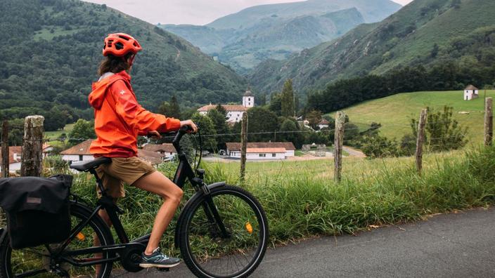
Families and mid-level athletes should consider the boost of the electric bicycle.
Even purists will need to be well trained to cross the passes that line the course.
Read the dossierCycling and cycling: all our advice and itineraries
If it does not follow any cycle route or greenway, the route connects some of the wonders of the hinterland, sometimes strangely deserted by visitors, through small departmental roads.
You have to be relatively independent: take a road map at a scale of 1: 150,000 maximum and a little mechanic's equipment is essential.
Also plan two side bags to attach to the frame, the content of which will vary depending on whether you sleep in a tent or in a lodge.
This full crossing of the Pyrénées-Atlantiques from Béarn can be done from May to October.
Watch out for the weather: rain and low temperatures are common on the peaks of the Pyrenees, even in midsummer.
Read the dossierCycling and cycling: all our advice and itineraries
1st stage: from Lourdes to Arudy
The reliefs are still present.
The height difference should not be underestimated.
Aymeric Guittet / Le Figaro
Distance:
45 km
Elevation:
+ 575 m
The virtual start line is in
Lourdes
, a major pilgrimage site, and very close to the border between Hautes-Pyrénées and Pyrénées-Atlantiques. The first pedal strokes lead us due west, right bank of the Gave de
Pau
, which we cross after about ten kilometers to take the D152 to
Saint-Pé-de-Bigorre
. There, it is difficult to ignore the Bétharram Caves, discovered in 1819 by a former grognard of Napoleon, and which stretch over more than 8 km. Further on, another type of wonder is revealed: the Marian sanctuary of Bétharram, a masterpiece of Baroque art in Béarn.
The rest of the route is more hilly: we aim for the small village of
Lys
, lost in the heart of a wooded landscape, and by narrow paths that nature and people seem to have calibrated for two-wheelers, we reach
Sévignacq- Meyracq
(12th century castle, 14th century church) and
Arudy
.
Variation:
From Notre-Dame de Bétharram, cyclists can choose to ride at the foot of the first Pyrenean mountains, via Arthez-d'Asson and Pé de Hourat.
The mileage is almost the same, but the vertical drop is higher.
Read also Lourdes, the unmissable places for a rejuvenating stay at the gateway to the Pyrenees
2nd stage: from Arudy to Tardets-Sorholus
Near the hamlet of Boucau, we cross the Béarn-Basque Country limit.
Aymeric Guittet / Le Figaro
Distance:
58 km
Elevation:
+ 800 m
From
Arudy
, the D918 runs through the forest.
After a long descent, we quickly pass
Lurbe-Saint-Christau
to reach the small hamlet of
Issor
.
From there, it is possible to get off the D918 for a while for an incursion into the Pyrenees via the Gorges de Lourdios (D241).
At the exit of these, one is so close to the border that the signs are also in Spanish.
Once back on the D918, it is possible to have lunch in the pretty village of
Arette
.
We can then make a new infidelity to the D918 by taking in turn the D459 and the D59, where we can pedal for an hour in the middle of the fields without crossing anyone.
In
Montory
, a surprise awaits us: a first pediment, a new language, baigorry red and dark green colors.
We crossed without knowing it the border between Béarn and the Basque Country.
Variation:
It is of course possible to avoid these convolutions around the D918, and to shoot as short as possible between Lurbe-St-Christau and Tardets-Sorholus, thus saving mileage and height difference.
3rd stage: From Tardets-Sorholus to Saint-Jean-Pied-de-Port
On the D117, in the heart of the Apanice pastures, the "prairies of a thousand dangers".
Opposite, the Béhorléguy peak.
Aymeric Guittet / Le Figaro
Distance:
40 km
Elevation:
+ 1100 m
This day is perhaps the most beautiful of the crossing, however at the cost of the most physical effort.
In the early morning, we join
Alçay
to take the direction of the Ahüzkia fountain.
Prepare your "rods" for 1000 meters of ascent, fortunately quite gradual.
After two to three hours, you come to a large plateau where the panorama opens for the first time on the Lutogagne (1097 m) and the Pic des Escaliers (1472 m).
The vegetation becomes clear, and the bike slaloms between horses and Manechs (sheep) in semi-freedom.
A short break can be considered at the source of Ahüzkia: in the 19th century, its virtues attracted many curists, who absorbed up to ... 15 liters per day. Shortly after, the track seems to narrow under the clouds and the wind. On this vast plateau without a living soul, streaked with invisible chasms which have earned it its nickname "prairie of a thousand dangers", this departmental 117 seems forgotten. Once you reach the Béhorléguy peak (1265 m), the valley is revealed, 800 meters below. A great descent of 20 kilometers, which the more adventurous will make at 50 km / h, will lead you near
Saint-Jean-Pied-de-Port
.
Variation:
if you want to partly avoid the drop in this third stage, you can reach Saint-Jean from the north, staying on the D918 (quite busy) then cutting through the D120.
Read alsoFrom Bayonne to Hendaye, our 10 favorite restaurants on the Basque Coast
4th stage: from Saint-Jean-Pied-de-Port to Espelette
In the streets of Saint-Jean-Pied-de-Port.
Aymeric Guittet / Le Figaro
Distance:
41 km
Elevation:
+ 750 m
For this journey, you have to be cunning. Approaching the coast, the D918 becomes a very busy artery and frankly unpleasant to borrow by bike. The solution, as often, goes through the winding mountain paths. After a tour of the Citadel of Saint-Jean-Pied-de-Port, a former stronghold of the passage from the Pyrenees to Spain, it is necessary to cross the right bank of the Nive, under the Pic d'Arradoy (630 m) . A dry but short climb allows you to reach the ridges, where the gaze reaches up to the Spanish peaks.
Via
Irissarry
then
Louhossoa
, we reach
Itxassou
where our memories of history books are summoned: this village is particularly known for the Pas de Roland, the rocky arch on the banks of the Nive, which legend has it was pierced by Charlemagne's nephew.
The place is however overcrowded in high season, and we would definitely prefer a stroll around the church of Itxassou.
Then, direction Espelette, which is 6 km away.
The road that leads there crosses corn fields pierced by traditional farms.
Variation:
If you want to avoid both the D918 vehicles and the climb towards the ridges, the D22, east of St-Jean-Pied-de-Port, allows you to reach Irissarry then Espelette without incident.
5th stage: from Espelette to Guéthary
Arrival in Guéthary in the morning.
Aymeric Guittet / Le Figaro
Distance:
25 km
Elevation:
+ 350 m
Tourist epicenter, Espelette quickly gets crowded in high season.
To enjoy its pretty streets marbled with white houses with baigorry red and green shutters, you have to walk there before 9:30 am.
Cafés and shops allow you to get your fill before getting back on the road for a smooth last day, always making sure to avoid the main roads.
By borrowing the D89 then the D855, one reaches the village of
Ahetze
while contemplating on the left the Ibanteli and the Rhune.
The relief softens, the ocean is very close.
After Ahetze, do not miss the D855-Chemin de Laharraga branch, to reach
Guéthary
via its church.
This is where the Atlantic is revealed.
The journey ends in front of the great waves of Parliamentia.
Variant:
From the D89, you can take a detour via Saint-Pée-sur-Nivelle, its castle and its church.


/cloudfront-eu-central-1.images.arcpublishing.com/prisa/J2VDVTKJDFJFTKIHMGO55426UU.jpg)

/cloudfront-eu-central-1.images.arcpublishing.com/prisa/LBSMGW4JUBAODL5PC4BABWYEL4.jpg)