
The Northeast Gale or Storm Signal No. 8 is now in effect.
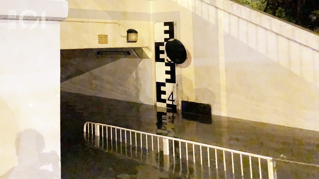
At around 1 am on the 13th, at the time of high tide, the footpaths and bicycle tracks on both sides of the Shing Mun River in Sha Tin were flooded by the river due to the impact of the storm surge. Among them, the pedestrian tunnels under the Shayan Bridge and Cuirong Bridge were even deeper. Beyond the "foot eye" position.
Some people who sleep on the bottom of the bridge immediately wade into the area under the bridge after discovering the flooding, and try to remove their personal property and street-sleeping supplies. During this period, "surges" rushed onto the pedestrian path and the situation was quite embarrassing.
+12
According to the scene, according to the measuring stick attached to the wall of the pedestrian tunnel of Shayan Bridge, the height of sea water measured is about 4 meters above the base of the chart.
The actual depth of water in the tunnel is approximately to the calf.
According to the tidal measurement data of the Observatory, the nearest measurement point to Sha Tin is Tai Po Kau Ti Station. At 1:55 am on the 13th, the recorded tide height was 3.5 meters above the base of the chart; the predicted value was only 2.38 meters.
According to the information, the main level benchmark on the west bank of Shing Mun River is about 2.7 meters. If the tide is higher than 2.7 meters, flooding will occur.
When Typhoon Mangkhut hit Hong Kong in 2018, the Shing Mun River was severely flooded and flooded on both sides of the river. The sea level at the Tai Po Jiao Tidal Station reached 4.54 meters above the base of the chart.
The Tai Po Kau Tidal Station of the Observatory, at 1:55 in the morning, measured the height of the sea to reach 3.5 meters above the base of the chart.
01News


/cloudfront-eu-central-1.images.arcpublishing.com/prisa/KMEYMJKESBAZBE4MRBAM4TGHIQ.jpg)


