
Biden: The first thing I did was go back to the Paris Agreement 0:33
(CNN) -
It's time to keep an eye on the weather, as a barrage of weather threats unfolds across the United States this week, creating dangers from coast to coast.
From "bomb cyclones" to bad weather and nor'easters, this week has it all.
Evacuation orders in some burned areas of California
As a "bomb cyclone" turns into a downpour across the West, new evacuation orders have been issued for vulnerable locations near the recent fire scars.
Santa Barbara County officials have elevated the recent evacuation warning to an evacuation order for parts of the area burned by the Alisal fire.
Concerns are growing about the possibility of dangerous debris flows due to the forecast of heavy rains on the recently burned land.
Evacuation orders mean that it is illegal to stay at the scene, with an immediate threat to life and property.
advertising
Flash floods hit Birmingham, Alabama 0:43
The threats associated with this atmospheric river do not stop there.
Several feet of snow is forecast in the Sierra Nevada mountain range, creating near-impossible driving conditions, according to the National Weather Service (NWS) office in Hanford, California.
Large travel delays are expected as chain controls and road closures are likely to be implemented.
The most intense snowfalls were expected to occur at night from Sunday to Monday and will be more intense at elevations above 1,500 meters.
Strong winds with gusts of more than 80 kilometers per hour will accompany the heavy, wet snow.
Florida to abandon palm trees to combat climate crisis
The NWS has flash flood advisories for a large area of central and northern California.
Rain accumulations of 76 to 152 millimeters, with amounts locally exceeding 255 millimeters, will lead to localized flash floods, landslides and rock falls.
Especially vulnerable roads and streams are most at risk from this event, as heavy rains are expected to last through Monday.
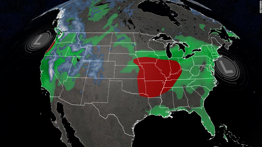
Possible outbreak of tornadoes through Monday
Adverse weather conditions are likely to occur early this week across much of the country.
The stage is being set for an outbreak that begins this Sunday through the middle Mississippi Valley that will move east to the Carolinas and the mid-Atlantic states by Monday.
Tornadoes, large hail and damaging winds have been reported through Sunday night in parts of Arkansas, Missouri, Illinois and Indiana.
However, the Storm Prediction Center has highlighted a specific area from St. Louis to Springfield, Missouri, as a significant tornado threat.
This region has a greater than 10% probability of a strong tornado (EF-2 to EF-5) occurring within a 40-kilometer radius of any particular point.
USA, the most CO2-generating country in history 0:53
Fall is often considered a secondary peak season for severe weather events in the United States.
The large fluctuations in temperature associated with the change of season can contribute to the development of severe meteorological phenomena.
Although tornadoes can strike at any time of the year, fall typically experiences increased activity as warm, humid air from the south interacts with increasingly powerful cold fronts from the north.
Weather models point to a possible nor'easter in the middle of the week
⚠️The potential for a very powerful Nor'easter is increasing for Tues / Wed of upcoming week.
The track of the developing Low Pressure will determine if / where hurricane force wind gusts impact the coast including Boston.
Yes, this is a major bomb cyclone.
pic.twitter.com/3qkW9GPfBo
- Ryan (@RyanMaue) October 24, 2021
The same energy associated with the severe weather outbreak will translate into a powerful low-pressure system known as nor'easter along the US east coast by Tuesday and Wednesday.
Conditions seem favorable for strong northeast winds to develop, which is how a nor'easter gets its name.
Coastal flooding and heavy rains are also possible in southern New England.
Specific details of the forecast are still unknown, as there are still days to go before this phenomenon occurs, but there is the possibility of urban and street flooding.
Some computer models predict more than 150 millimeters of rainfall in the region.
Since fall leaves have yet to fall across much of New England, high winds could easily knock down trees and branches.
This could lead to power outages throughout the region.
climate


/cloudfront-eu-central-1.images.arcpublishing.com/prisa/KMEYMJKESBAZBE4MRBAM4TGHIQ.jpg)


