Lovers of calm and wide open spaces, travelers in search of wild nature, rushing torrents, caves and peaks, you have arrived at your destination. Ariège, Occitan and Pyrenean department, is an ode to nature, escape and freedom. Judge rather, its prefecture has barely more than 9,000 inhabitants while two thirds of its area is located in mountain areas. From the gates of Toulouse to the Spanish and Andorran borders, Ariège stretches its hillsides, its lakes, its steep valleys, its impenetrable forests, under the watchful eye of the sharp peaks which culminate, for the highest, beyond 3,000 meters altitude.
Here, in this eastern part of the Pyrenees, from Donezan to Couserans, from the Ariège valley to Plantaurel, we travel in complete privacy.
In autumn, in spring and even in summer, Ariège reveals its natural treasures, far, very far from the tourist flows.
Read alsoHow to choose the right hiking boots
Mas d'Azil, monumental cavity
In Mas-d'Azil, the Arize river hollowed out the Plantaurel limestone to form a cave of such spectacular dimensions that a road crosses it right through.
Stéphane Meurisse - ADT Ariège
It is a site which is worth as much for its prehistoric heritage as for its geological splendor.
In Mas-d'Azil, the Arize river hollowed out the Plantaurel limestone to form a cave of such spectacular dimensions that a road crosses it right through.
With its 50 meters high yet wide, the main entrance sets the tone.
Everything here is gigantic.
The first prehistoric men were not mistaken because they lived there from 17,000 years before the present.
The Mas d'Azil cave also gave its name to the so-called “Azilian” period.
Today, it is no longer populated by a large colony of bats.
Our advice
In addition to the visit of the prehistoric cave (entry at 9 €), try the hikes (1h30 to 2h each) which go around the cave, either by the north entrance or by the south entrance.
Both routes offer a dizzying but secure passage along the wall, 100 meters above the river.
How to get there :
From Toulouse, take the A64 and exit at Carbonne.
Join Montesquieu-Volvestre, go up the Arize valley and cross the village of Mas-d'Azil (1h15).
The car park is located at the southern entrance to the cave.
Read also Chestnuts and beautiful autumn hikes: now is the right time to visit the Ardèche
Roquefort, petrifying waterfalls
Cascades de Roquefort Tourist office Cathar country / Laurent Graupera
The thick forest which clings to the slopes of Plantaurel, between Foix and Lavelanet, shelters a geological curiosity.
Thirty meters high, in lush vegetation, the waterfalls of Turasse (or Roquefort) have produced a phenomenon as rare as it is fragile: a tufa, in other words a petrifying waterfall formed of a crumbly and powdery limestone of white color to beige.
As you descend the mountain, the tuff settles on the mosses and pieces of wood, creating a thin, fragile crust.
This phenomenon is particularly spectacular in autumn and spring, a few hours after a fine downpour.
In winter, the frozen waterfall is worth a look.
In summer, however, it is often dry.
How to get there :
From Toulouse, take the A66 then the RN 20. At the entrance to Foix, take the D1 (direction Lavelanet) to Roquefort-les-Cascades.
The waterfalls are located south of the village (1h20).
Read alsoThe GR de Pays Grand Pic Saint-Loup elected favorite hiking trail of the French
Les Quiés du Tarasconnais or the heritage of glaciers
The quiés are real natural monuments, the most emblematic of which is certainly that of Sinsat.
Vincent Lebas
From the national road 20 which heads towards Spain, you have to twist your neck to see the top of the cliff, some 800 meters higher!
Several tens of thousands of years ago, the Ariège valley was buried under ice.
In Tarascon-sur-Ariège, the glacier even reached up to 800 meters thick.
It was at this time that he cut the rock to form quiés, real natural monuments, the most emblematic of which is certainly that of Sinsat.
In addition to the climbers who venture on climbing routes 300 meters long, many peregrine falcons, Egyptian vultures or the golden eagle frequent these vertiginous walls dressed in vegetation typical of dry environments, with its small oaks. greens and junipers.
Our advice
To immerse yourself in this vertical universe, a hike starting from the church of Verdun climbs to the top of the rock of Mirouge (1451 m), passing by the chapel of Sourdeign.
After two good hours of walking, the view of the glacial valley of Ariège is breathtaking.
How to get there :
From Toulouse, take the A66 to Pamiers, then the N20 to Sinsat (1h10).
For the hike to the rock of Mirouge, continue on the D220 which crosses the Ariège before reaching Verdun.
Bethmale lake
Lake Bethmale is one of the most bucolic in the Pyrenees.
Studio Léon - ADT Ariège
When autumn tints the beech grove red and yellow, Lake Bethmale imposes its splendor more than ever.
The trees are reflected in its emerald waters and this corner of the Couserans exudes a scent of exquisite poetry.
Perched at an altitude of 1,074 meters, just below the Col de la Core, this lake is one of the most bucolic in the Pyrenees.
The hundred-year-old forest which surrounds it envelops the site of tranquility.
The valley of Bethmale is also famous for its pretty villages, its wooden clogs and its cows with the milk of which one makes the cheese of… Bethmale.
Our advice
Stop by the Core Cazalas cheese dairy to discover the secret of the making and, above all, to taste the Bethmale cheese.
Otherwise, go to the colorful market in Saint-Girons on Saturday.
How to get there:
From Toulouse, take the A64.
Exit at Saint-Martory and join Saint-Girons, then Les Bordes-sur-Lez.
Follow the direction of the Col de la Core until a hairpin bend from which the lake track starts (2 hours).
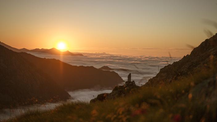
Mont Valier, lord of Couserans
Mount Valierv sits at an altitude of 2,838 m in the heart of the Couserans State Reserve.
Aurore Degeilh
It is certainly not the highest, but its forward position and the roughness of its ascent make it one of the most emblematic peaks of Ariège.
Mont Valier, Lord of Couserans, sits at an altitude of 2,838 m in the heart of the eponymous state reserve inhabited by chamois, capercaillie and other bearded vultures.
Its ascent - count 10h30 round trip and nearly 1900 meters of elevation gain - is reserved for trained mountain dwellers.
The ideal is to do it in two days, spending the night at the Estagnous refuge renowned for its panorama and for its cuisine.
At sunrise and sunset, Mont Valier is simply sublime.
Our advice
The Valier massif is home to the Arcouzan glacier, the easternmost of the Pyrenees.
To access it or for all other sporting hikes, contact the Ariège guides office.
How to get there :
From Toulouse, take the A64.
Exit at Saint-Martory and join Saint-Girons, then Castillon-en-Couserans.
Then go up the Ribérot valley to its end (2 hours).
Read alsoThree essential tips for a successful hike