
Thanksgiving at risk?
0:47
(CNN) -
As millions of Americans prepare to travel this week's Thanksgiving holiday, forecast models continue to show a rollercoaster of temperatures and a powerful storm this week.
Starting Sunday, several states will face snow, ice and destructive winds.
And a secondary system will bring more travel problems in the middle of the week.
Are you traveling by plane for the holidays?
There may be delays and it will be a bumpy ride.
Thanksgiving Dinner Will Cost Americans 14% More This Year, Survey Finds
Here's the breakdown of the forecast by days.
Sunday
Possible delays at airports for Sunday, November 21, 2021, according to forecasts.
From the Great Lakes to the Gulf Coast, rain will be the main threat, although snow showers will sometimes mix in parts of the upper Midwest.
advertising
"A powerful cold front delivers an injection of considerably colder temperatures across the Midwest and the Great Lakes late Sunday through Monday, causing heavy lake-effect snow showers to break into the Great Lakes wind on Monday." said the Weather Forecast Center (WPC) on Saturday.
"Ahead of the cold front of the storm system, numerous rains are forecast from the deep south to the north of the Mid-Atlantic on Sunday afternoon. These rains are expected to reach the northeast and extend as far south as the southeast on Sunday night. "
All that rain in Detroit, Milwaukee, Cincinnati, Atlanta, Memphis, and Pittsburgh can lead to some delays at airports, as well as traffic jams on freeways and highways.
In general, rain accumulations are expected to be around 2.5 centimeters or less, but some isolated spots could collect as much as 7.6 cm.
"Heavy rain and isolated instances of possible flash flooding across parts of eastern Florida and southern Texas today," the WPC said Sunday morning.
🥶Blustery conditions develop mid-afternoon Sunday as a push of colder arctic air arrives.
Wind chill values fall into the single digits by Sunday evening and linger into Monday.
#wiwx pic.twitter.com/G7lOJwy9dX
- NWS Milwaukee (@NWSMilwaukee) November 19, 2021
Strong winds will begin to blow across the North Plains this Sunday, moving toward the Midwest on Monday.
This could lead to significant delays for airlines, as well as very turbulent flights in some locations.
Monday
On Monday, the cold front will extend from Maine to Florida, with rain and wind as the main threats.
Cleveland, Syracuse and Buffalo in New York will have snow in the forecast along with gusty winds.
"The rain will transition to rain and snow showers on Monday behind a strong cold front," the National Weather Service office in Buffalo said in a dangerous weather outlook.
"Lake effect snow will then develop Monday night through Tuesday. Several inches of accumulation are likely in the more persistent lake snow."
While Chicago, Milwaukee and Detroit will begin to dry out on Monday, very gusty crosswinds of 32-56 km / h could cause flight delays.
Even cities as far south as Knoxville, Tennessee, and Atlanta could have gusty winds on Monday.
"Pilots will be looking for the smoothest air to fly, but many passengers will surely hear 'Ladies and gentlemen, please keep your seat belts on tight,'" said CNN meteorologist Chad Myers.
Monday, Tuesday and Wednesday will bring strong winds to the northeast, which could cause some flight delays in Boston, New York and Washington.
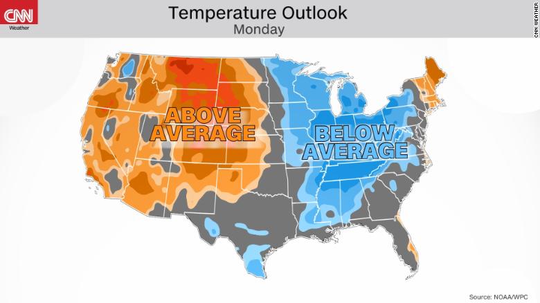
Monday also marks another big day of temperature swings across the country.
Temperatures in much of the Midwest and the Ohio River Valley will be well below normal.
Cincinnati, Indianapolis, Detroit, Nashville, Tennessee and St. Louis will have high temperatures 10-15 degrees below the seasonal mean (° F).
Above-average temperatures will be limited to the area between Denver and the Canadian border, where high temperatures will be 15-20 degrees above normal.
First Day of Thanksgiving Air Travel Period Breaks Pandemic Record, Says TSA
Tuesday
By Tuesday, persistent snow showers will linger across the eastern Great Lakes, as a new low-pressure system moves into the Western Mountains.
This storm will become the focal point of travel problems in the Midwest on Wednesday.
Thanks to yesterday's system, the Northeast will continue to deal with rain, snow, and gusty winds that could turn roads and tracks into a mess.
"Possible heavy rains for parts of the South Plains and Lower Mississippi Valley may affect travel for the Thanksgiving holiday," the WPC said.
It must be taken into account that there is still enough uncertainty in the evolution of this system to allow other types of precipitation.
If temperatures are warmer by just a few degrees, it will mean the difference between snow and rain for various states.
"Mother Nature" could also complicate your vacation thanks to large swings in temperatures.
From Boston to Jacksonville, Tuesday temperatures will be 10-15 degrees below normal, making it feel like more Christmas than Thanksgiving.
The Intermountain West and High Plains regions will suffer the opposite effect.
From Amarillo, Texas, to Bismarck, North Dakota, temperatures will be 15-30 degrees above normal on Tuesday, resembling Halloween temperatures more than Thanksgiving temperatures.
As the next system begins to push into the Pacific Northwest, Seattle and Portland, Oregon will likely collect 635mm or 127mm of rain.
Wednesday
Wednesday will give a little respite to the Southeast, but the windy conditions become the center of attention for a large swath, from Michigan to Texas.
Chicago, St. Louis, Dallas and Oklahoma City will likely have to deal with 20 to 30 mph winds throughout the day.
The secondary system will move to the Midwest late Wednesday.
Rain, snow, and even ice are possible for Michigan, Wisconsin, and Illinois, which could be very dangerous for road and air travel.
Finally, a new system will begin to enter the West of the Mountains.
Snow showers are possible in Denver and Salt Lake City.
"Across the northern strip, the combination of low temperatures and wind would produce low temperatures," said the WPC.
Thanksgiving could feel more like Christmas
A cold front will bring showers from Texas to Ohio, along with some snow showers for Michigan, Wisconsin and Minnesota.
Temperatures will return to normal on Thursday across much of the eastern half of the US, but keep in mind that "normal" may still be cold.
The first half of next week looks quiet and dry ... but changes are coming as we head into Thanksgiving!
Rain chances are expected to increase area wide Wednesday night continuing into Thursday.
Here's the latest details!
Stay tuned for updates.
#dfwwx #ctxwx pic.twitter.com/NxBwTMED8D
- NWS Fort Worth (@NWSFortWorth) November 20, 2021
In New York, temperatures are likely to fall below 40 degrees, so those who venture to see the great morning parade, bundle up warm.
And the return home?
Although the forecast for the weekend after Thanksgiving is a long way from now, there are two areas that appear to be more likely than others to experience dangerous travel: the Pacific Northwest and the Gulf Coast region.
CNN Meteorologist Judson Jones contributed to this article.
weatherThanksgivingThanksgiving


