
Is there a difference between a typhoon and a hurricane?
0:49
(CNN) -
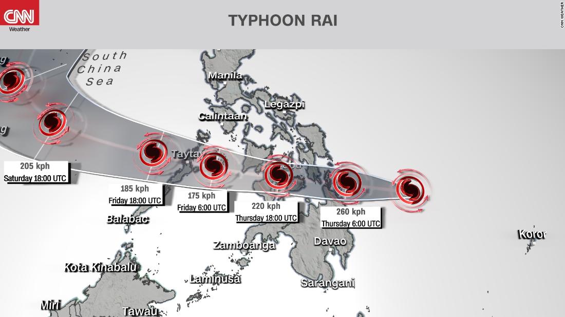
Rai is rapidly strengthening in the eastern southern Philippines and may be on the verge of becoming a super typhoon.
The storm is on its way to hit the southern and central parts of the country this Thursday.
Currently, Rai has sustained winds of 215 km / h, making it the equivalent of a Category 4 hurricane on the Saffir-Simpson Hurricane Wind Scale.
Favorable conditions across the region, including very warm ocean waters and low wind shear, led the storm to intensify from a tropical storm to a potentially catastrophic high-level typhoon in the past 24 hours.
Further strengthening is expected, and the current forecast from the Joint Typhoon Warning Center is for Rai to reach 260 km / h upon landfall.
This would make Rai the equivalent of a Category 5 hurricane or super typhoon.
In the Philippines, the storm is known as Odette and is being monitored by the Philippine Atmospheric, Geophysical and Astronomical Services Administration (PAGASA).
advertising
The outer bands of the storm are already spreading rain toward the southern and central regions of the country and conditions will deteriorate rapidly in the coming hours.
It is already Thursday in the Philippines, and from Thursday morning to Friday morning, the rains are expected to be "heavy to intense and at times torrential," PAGASA said in its forecast bulletin early Thursday morning.
More than 250mm of rain will fall on parts of Mindanao and the Visayas.
The heavy rain is expected to cause widespread flooding, flash flooding, and landslides on higher ground.
PAGASA has already issued the tropical cyclone 3 warning signal for high winds in the southern portions of the Visayas and northern Mindanao.
As the storm approaches land on Thursday afternoon locally, PAGASA may raise the warning signal to 4 or even 5, the top of its chart.
In addition to strong winds, floods and landslides, coastal regions will be on alert for three to four meter storms and vessels will face extremely rough seas over the next few days.
December storms are not uncommon
In the Western Pacific, there is no defined "season" for tropical systems as there is in other basins such as the North Atlantic (June 1 to November 30).
While activity peaks in late summer through early fall, storms can strike any month of the year.
The Philippines is no stranger to the catastrophic storms in December.
In the last decade, numerous intense and deadly storms have affected the region.
In 2011, Tropical Storm Washi killed more than 1,000 people in the southern Philippines and never reached typhoon status.
The storm was comparatively weak, but it dumped huge amounts of rain, causing devastating flash floods and landslides during the night hours while people slept.
Just a year later, in December 2012, Bopha also hit the Mindanao region of the southern Philippines.
Bopha was much stronger than Washi, hitting the region like a super typhoon and killing more than 1,000 people.
The Philippines was also hit by strong and deadly typhoons in December 2014 (Hagupit) and 2016, when Typhoon Nockten struck on Christmas Day.
Typhoon