
This is what the destructive force of the winter storm that threatens the US looks like. 3:27
(CNN) —
A ferocious winter storm will barrel through parts of the Southeast this Sunday, dumping freezing rain, ice and snow on cities and states that don't normally see much of the white stuff.
As many as 80 million people are under winter weather warnings from that region to the Northeast, CNN meteorologist Derek Van Dam said.
"I am particularly concerned about the impending ice storm that will affect the interior of South and North Carolina. After a round of heavy snow, up to 1.9 cm of ice could accumulate," Van Dam said.
"This will certainly bring power outages to the area as wind gusts exceed 40 mph," he added.
Motorists stranded for hours by winter storm in Virginia
Greenville, South Carolina, and Charlotte and Raleigh in North Carolina are under winter storm warnings, forecasters said.
As much as 12 inches of snow could fall near Blue Ridge in Greenville and up to 20 inches of snow could accumulate above 4,000 feet in that area.
0.2 cm of ice is also possible.
advertising
The National Weather Service (NWS) has issued an ice storm warning for parts of South Carolina, in effect through early Monday, with temperatures likely to remain below freezing through the start of next week.
"Significant amounts of ice accumulation will make travel hazardous or impossible. Travel is strongly discouraged," the NWS office in Greenville said.
Check this site to check if snow is forecast for your region
Charlotte could accumulate up to a foot of snow on the hills, and possibly up to 1.2 cm of ice.
Raleigh is expected to see up to 5cm of snow and perhaps 0.6cm of ice, forecasters said.
The NWS warns that ice dams will be very dangerous along and east of I-85, including Spartanburg, South Carolina, to Salisbury, North Carolina.
This includes the entire Charlotte metro area.
"The highest snowfall totals are expected along the Appalachian spine as well as the lower Great Lakes," the National Weather Service said early Sunday.
Key Messages for the winter storm moving through the Mid-South have been updated.
Stay up-to-date with the latest forecast as conditions can change rapidly!
pic.twitter.com/6AQdjJFG2n
— NWS Weather Prediction Center (@NWSWPC) January 15, 2022
"More significant ice formation is expected over the Carolinas this morning. Significant impacts are expected to travel through these regions," the NWS noted.
Snowfall rates could exceed 1 inch per hour from northeast Georgia to the western Carolinas and far eastern Tennessee, the Storm Prediction Center said.
Heavy snow is also possible in West Virginia.
This could save your life if your car gets caught in a winter storm 1:16
From the Mid-Atlantic to New England, the NWS said, "precipitation is forecast to start as snow before changing to ice/sleet and eventually rain with the approach of the storm center."
The governors of Georgia, North Carolina, South Carolina, and Virginia declared states of emergency, allowing resources to be positioned ahead of the storm's arrival.
Parts of north and central Georgia could also see strong winds on Sunday, the National Weather Service in Atlanta said.
"With high winds and the possibility of winter weather, we are very concerned about downed trees and power lines that will knock out power through Sunday, so prepare now!"
wrote the service on Twitter on Saturday night.
Georgia Governor Brian Kemp directed the state Department of Defense to prepare 1,000 National Guard troops to assist in storm response.
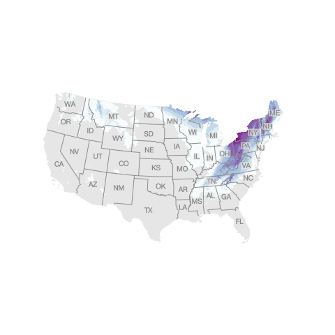
Where to expect snow in the next few days
Here's the snowfall total the National Weather Service predicts will fall in the contiguous United States.
Snow forecast through Wednesday at 7 am ET
Forecast as of Sunday, January 16 at 7:00 am ET.
Source: National Weather Service, US Census Bureau. Graphic: John Keefe, CNN
Mid and Northeast Atlantic
The storm will turn northeast toward the East Coast on Sunday and Monday.
Some snow will fall in major metropolitan areas, but a change in rainfall will stop the accumulations.
Washington could get 2 to 4 inches, while Philadelphia could get 1 to 2 inches.
New York and Boston are expected to get about 1 inch each.
Heavier snowfall is expected elsewhere, with more than a foot in some places.
"As is common with this storm track, the Shenandoah Valley into the Alleghenies will be the likely winner in terms of highest snowfall totals," NWS Baltimore said Saturday.
"17 to 25 centimeters is possible, but more than 30 centimeters is not out of the question where heavier bands form."
More than 200 million in the US are under alert as a deadly winter storm moves towards the Northeast
Snowfall intensity in the region may be heavy enough to prevent significant icing, but NWS Baltimore warns that untreated surfaces can still lead to dangerous travel conditions where ice builds up.
Most of the accumulated snowfall will occur from Sunday afternoon through Monday morning.
Inland cities like Charleston, Pittsburgh, Buffalo, Syracuse and Burlington, Vermont will see the heaviest snow.
Before the snow event reaches the region, the Northeast will experience frigid temperatures and a dangerous wind chill, forecasters said.
Coastal flooding is also expected
In addition to the potential for snowfall, strong easterly winds associated with the storm system could cause extensive coastal flooding of up to 0.9 meters above ground in some areas along the northeast coast at high tide.
Parts of New York City, Long Island and some areas of Connecticut are under coastal flood warnings, forecasters said.
The timing of winds shifting from east to south will largely determine the severity of flooding, with moderate flood potential if winds shift before high tide.
There will be a strong coastal storm approaching Sunday night and moving through early Monday with increasing concerns about coastal flooding and high winds.
Coastal flood watches are in effect for much of our coastlines for high tides on Monday.
#NYCwx #NYwx #NJwx #CTwx pic.twitter.com/c7pb2MhIae
— NWS New York NY (@NWSNewYorkNY) January 15, 2022
“Moderate to locally significant widespread flooding of vulnerable areas near the shoreline is possible, including roads, parking lots, parks, lawns, and homes and businesses with basements near the shoreline,” the NWS in New York said Saturday.
Flooding could lead to road closures and structural damage along the Atlantic coast.
CNN Meteorologists Allison Chinchar, Chad Myers, Dave Hennen, Monica Garrett and Haley Brink contributed to this story.
North CarolinaSouth CarolinaNew Yorkwinter storm


